Monday, 26 March 2018
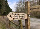
Yorkshire Wolds Way
Ganton → Filey
 Distance: 11.42 miles
Ascent: 378 metres
Duration: 3 hours 21 minutes
Sprint to the sea
« Not walked | Scarborough »
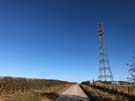
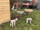
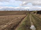
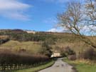
We had intended today to be far more leisurely. Instead we got up early and raced to Filey, frequent glimpses of the sea drawing us forwards.
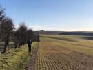 Despite the pace we had time to appreciate our final walk through a deep Wold, at Stocking Dale, where the trail is overhung by hawthorns and scrubby birches, and filled with the sounds of skylarks and songbirds. Once the path rose again to follow field edges, it felt like we'd reached the end of the rolling terrain that we'd become accustomed to. Instead of a sudden change, the landscape gently evened out into flat fields, with increasing numbers of houses. By the time we reached Muston it felt like we'd left a week's worth of pastoral wilderness behind us.
The plan to catch a late afternoon train home was scuppered by Northern Railway massively reducing their services today due to industrial action by the RMT. That left us with twelve miles to cover before the one and only train at 1230; a tall order, but just about achievable. In the end, we found we'd covered the distance at 3.3mph – too fast to really appreciate the scenery.
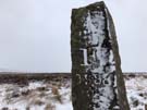
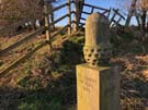 Since leaving Hessle we've passed sturdy acorn distance markers every five miles measuring the distance from each end of the trail. These seem to be a unique feature of the Yorkshire Wolds Way, but I'd love to see them adopted by other National Trails — they provide a reassuring rhythm to the walk and an encouragement of progress being made, counting down to the finish line.
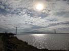
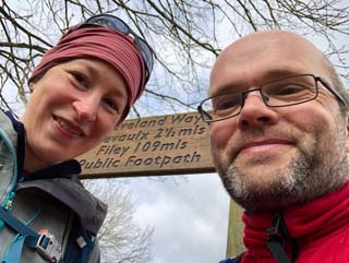
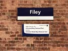 We reached Filey with almost an hour to spare; sufficient time to drop to the prom where we linked this walk with our coastwalk but not quite enough to make it to the formal end of the trail and back. (Good job we walked that stretch back in 2013 then.) The Yorkshire Wolds Way ends where the Cleveland Way begins, on the top of Filey Brigg. In a way we've come full circle this week.
So that's National Trail number twelve complete. Depending on how you count, just two or three more to go, and we're already over half-way through the longest of those.
Sunday, 25 March 2018
Yorkshire Wolds Way
Thixendale → Ganton
 Distance: 21.95 miles
Ascent: 718 metres
Duration: 7 hours 3 minutes
Springtime
« Not walked | Not walked »
 Spring has well and truly sprung, although there was a little frost on the ground first thing before the sun had risen over the deep Thixen Dale. The clear skies transformed the rest of the day. There wasn't a cloud in sight, and the contrast between today's glorious weather and that of the previous weekend is remarkable.
 The highlight of this leg was always going to be the abandoned medieval village of Wharram Percy. For us, this came after a four mile walk across empty valleys, a much more evocative way of approaching the site than the 500 metre jaunt from the car park. All is not as it seems though. The derelict church was in regular use until 1949, its ruined appearance dating from ten years later when the tower fell. Of the medieval village there is little to see — just outlines of buildings on the ground. Even less evident is the railway which passed through the site until the Beeching cuts. This isn't the cut-off place that romanticists would have you believe.
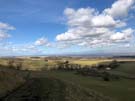
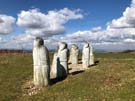 The landscape changed again on this section, deep dales giving way to a defined escarpment edge, and just after passing Wintringham we caught our first glimpse of the North Sea. At West Knapton, the point where we turned east, stands a modern artwork said to depict the Enclosures Act, but it left me rather cold.
We didn't linger long; we had a lot of ground to cover — more than originally intended, but we've set ourselves up very nicely for the final push tomorrow.
Saturday, 24 March 2018
Yorkshire Wolds Way
Goodmanham → Thixendale
 Distance: 20.27 miles
Ascent: 798 metres
Duration: 6 hours 51 minutes
Folds and dales
« Not walked | Not walked »
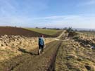
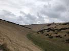 Our B&B hosts - both seasoned Wolds Way walkers - warned us that the route would dramatically change at Millington, so we set off with a degree of foreboding. The path from Goodmanham to Millington was much the same as yesterday: all arable fields and chalk downs. But once we'd climbed above Millington village we crossed a succession of winding, deep and empty dales.
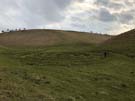 The sensation was rather claustrophobic. Alone apart from the sheep, there was nowhere to run, and no civilisation for comfort. The grassy hillsides towered over us and the only escape was to walk to the end of the dale, rather like being trapped in a tunnel. The villages in these undulating hills often get cut off after heavy snow; it's not hard to see why.
I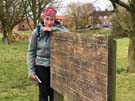 n Thixendale we passed the halfway mark for the Yorkshire Wolds Way. It's come about so quickly; a product of this being the shortest National Trail and the fact that we've taken on a pretty long day today.
Tonight we're staying in the Cross Keys in Thixendale. There's no mobile reception, no television and no Wi-Fi. The comforts and securities of our modern lives are absent, but sat next to the open fire, listening to the chatter of locals and visitors, waiting for a hearty pie, we couldn't be more content.
Friday, 23 March 2018
Yorkshire Wolds Way
South Cave → Goodmanham
 Distance: 11.30 miles
Ascent: 375 metres
Duration: 3 hours 38 minutes
A bit of south in the north
« Not walked | Not walked »
 For all its grandeur, and despite its quirks, the Cave Castle Country Club is a walker-friendly hotel. We weren't the only people at breakfast with a Wolds Way guidebook, and as we checked out the receptionist made sure that we'd "picked up some snacks for the walk" at breakfast. (Suddenly the individually wrapped pieces of homemade lemon drizzle cake at the cold buffet didn't seem out of place.)
The walk itself was very much a case of "getting on with the job," following a path that felt like many other National Trails of the south. Lots more chalk downland, reminiscent of the Ridgeway. Lots of straight, old, green lanes that reminded me of Peddars Way. At one point we even saw a vineyard, like on the North and South Downs. And to remind us that the weather still isn't settled, a dash of cold wind that for once had swung round to face us.
 The countryside here is getting bigger: the route took us across larger hills, and at one point through an extended dry valley, speckled with stony chalk. The landscape felt more undulating than yesterday's gentle introduction, as we turned away from the brown Humber estuary and headed deeper into the Wolds.
Even accounting for the better weather we've been surprised to see so many people on the Yorkshire Wolds Way. Our B&B hosts for tonight provided the answer: the trail has featured on TV a number of times this past year.
Thursday, 22 March 2018
Yorkshire Wolds Way
Hessle → South Cave
 Distance: 13.38 miles
Ascent: 381 metres
Duration: 4 hours 34 minutes
Yorkshire, part II
« Not walked | Not walked »
 The Yorkshire Wolds Way starts on the banks of the Humber, in the land of cream telephone boxes. We've been here before, on our coast walk. Back then it took us seven days to walk 105 miles to Filey along the coast. This week the Yorkshire Wolds Way should get us back there in five days, by the shorter 89 mile inland route.
 We may be broadly in the same part of the country as the Cleveland Way, but the landscape is quite different. The limestone escarpment is replaced by gently rolling chalk downland, the high moorland by huge arable fields. Thankfully, the weather has moved on too, with a real sense of spring in the air.
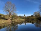
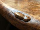
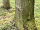 One charming link with earlier in the week is at All Saints, Brantingham. Standing in the churchyard are two wooden grave markers, quite simple in design but beautifully aged. Seventy years ago these were carved by Robert Thompson of Kilburn, whose workshop still produces furniture and other wooden objects, each adorned with a signature carved mouse. The ways these grave markers are slowly weathering and decaying fits perfectly with their purpose; before too long they too will have returned to the earth from which they were crafted.
We'll be keeping an eye out for more of Thompson's work as we make our way across the Wolds this week.
Wednesday, 21 March 2018
Cleveland Way
Kilburn White Horse → Helmsley
 Distance: 8.79 miles
Ascent: 176 metres
Duration: 3 hours 3 minutes
Wildlife wakes up
« Not walked | Not walked »
This final stage of the Cleveland Way is very different to all the others. Almost immediately the path turns its back on the escarpment edge and heads into rolling farmland. Soon it descends to follow a wooded glade towards the ruined abbey at Rievaulx. It's then a short (and seemingly popular) stroll through muddy fields to Helmsley and the end of the Cleveland Way.
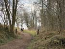 As the landscape changed, we started to notice more wildlife too. We left behind the grouse of the wild moorland, replacing them with phesants and partridges. Hares dashed across arable fields and deer scampered through the gently wooded slopes.
What a walk! Five years since we started walking this National Trail, we finished it having endured the worst weather we've ever walked through. Surely walking the 109 miles from Saltburn to Helmsley is enough? You'd be forgiven for thinking so, but we've still got half a week to go. Tomorrow we start another walk, another National Trail, and with Filey as our destination. Let's hope the weather plays along.
Tuesday, 20 March 2018
Cleveland Way
Osmotherley → Kilburn White Horse
 Distance: 13.91 miles
Ascent: 486 metres
Duration: 4 hours 57 minutes
The Hambleton Hills didn't get the memo
« Not walked | Not walked »
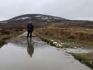
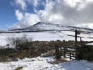
A brief amble around the outskirts of Osmotherley took us onto the edge of the Hambleton Hills, an area of heather-rich grouse moorland. As we skirted Black Hambleton we were gently snowed on, adding to that still lying; the general thaw hadn't reached here yet. Despite the drifts and slush, this was an easy, mostly level stretch that quickly brought us into woodland at Steeple Cross.
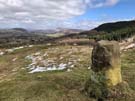
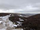 The Cleveland Way leaves the old drove road just before High Paradise Farm, and as tempting as it was to stop at the tea room, we headed south through a mixture of woodland and open fields, following the edge of the escarpment. The ridge swings back and forth, offering panoramic views across the plain to the east, before winding up Sutton Bank.
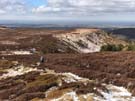
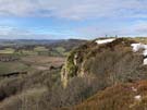 The residual snow — deep in places, melting to wide puddles of brown water — hid the outlines of some of the tumuli and disused quarry pits that mark the area, and made for slow going as we negotiated the limestone cliff edge. Our persistence was rewarded as we reached the end of Sutton Bank, accompanied by a glider taking off from the adjacent airstrip, and took what local author James Herriot claimed to be "England's finest" view to the south and east (though it was a little too hazy for us to agree).
 The white horse hill figure facing Kilburn is slightly less majestic — a greyish, lumpen nag close-up — but easier to appreciate from the village below.
 Although not on the path, it's worth visiting the village of Kilburn — particularly the church and pub — to see the woodwork of local craftsmen who adorn each of their pieces with a tiny church mouse. Founder Robert Thompson ("The Mouseman") is buried in the cemetery.
Monday, 19 March 2018
Cleveland Way
Garfit Gap (Wainstones) → Osmotherley
 Distance: 9.68 miles
Ascent: 672 metres
Duration: 4 hours 2 minutes
Thaw
« Not walked | Not walked »
"I hope you have a better day today than yesterday," offered a total stranger as we left the village this morning. Maybe word of our presence had leaked from the pub. Perhaps like the first cuckoo of spring, the first walkers to arrive indicate that winter is over.
And so it was. Throughout the day we watched the fields below the escarpment turn from dazzling winter white to luscious springtime green.
 The first descent after the aptly named Cold Moor was painfully slow, each foot having to be lowered gingerly into the drifts of snow. By the time we were making our third descent there was hardly any snow to be seen, and the final miles into Osmotherley were characterised more by mud than ice.
 The dry weather and blue skies opened up the views north and west. In the distance we could make out the backbone of the Pennines, laid out in a long row. We'll be back soon to finish them off.
 We've walked through the thaw and seen the seasons change before our eyes. The cold wind is still about, but it's lost its ferocity.
Sunday, 18 March 2018
Cleveland Way
Kildale → Garfit Gap (Wainstones)
 Distance: 10.89 miles
Ascent: 756 metres
Duration: 3 hours 57 minutes
Exposed
« Not walked | Not walked »
We seem to have become instant celebrities in the hotel where we're staying tonight. "You're the first walkers we've seen this year," said the receptionist at check-in. Her colleague was falling over himself to offer us a lift to the start of tomorrow's leg, a packed lunch, and advice for the route ahead. At the bar we were told we were "at least two weeks early for walking." Everybody expressed astonishment that we'd walked at all today. I think we share their surprise.
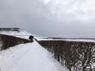
Snow continued to fall overnight and throughout the morning. The cold easterly didn't let up, gusting at 50mph and dropping the wind chill temperature to -10C.
 We saw scarcely a soul, so we had the views across the Cleveland Vale all to ourselves: a patchwork of crisp white fields, dotted with sheep huddled together for warmth. Ours were the only footprints in the virgin snowscape.
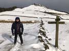
Climbing out of Kildale we passed a monument to the crew of a Hudson aeroplane that crashed nearby in January 1941. Although the four airmen survived the crash, they didn't survive the two days out in the cold before they were discovered.
 The highlight today was the descent through the rocky outcrop of the Wainstones. Here the snow had drifted 25cm deep in places. Thankfully by this time we'd started to see other footprints and were able to safely follow them through the maze of crags.
 No more snow is scheduled to fall, but tomorrow is still due to be bitterly cold. Hopefully the path will remain walkable, and not disintegrate into a paste of slush and mud.
Saturday, 17 March 2018
Cleveland Way
Saltburn-by-the-Sea → Kildale
 Distance: 15.39 miles
Ascent: 1089 metres
Duration: 5 hours 19 minutes
Snowberry Topping
« Runswick | Not walked »
For us 2018 is about unfinished business. We're trying to finish off all the National Trails in England and Wales. Five years ago we walked the coastal sections of the Cleveland Way; it's time to finish the trail with the inland leg.
This morning though, we weren't sure we'd even start. Overnight a bitterly cold easterly formed, bringing dangerously gusty winds and snow showers. The Met Office has responded with an Amber Warning, and were it not for the fact that we'd booked onward accommodation elsewhere we might have remained snug and warm in the Saltburn Spa Hotel.
Remarkably, we managed to walk the entire distance without having to execute any of the potential exit strategies we'd come up with.
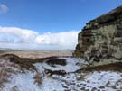 The snow arrived in short, sharp, needling bursts. One minute we were enjoying breathtaking views towards Middlesbrough and the coast in bright sunshine; the next we'd have quarter an hour of total whiteout, with powdery snow swirling around us as we were battered by the wind.
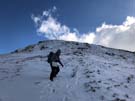
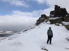
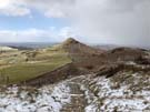 The highlight of the walk should have been Roseberry Topping, an isolated hill off the main Cleveland Ridge. Here the weather did its worst, with gusts threatening to blow us off the steep, stony path to the summit. The view from the top was glorious, but not one to linger over today.
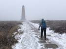
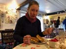
After passing a monument to Captain Cook, who grew up in nearby Great Ayton, we descended into Kildale and stopped at the most welcome Glebe Cottage Tea Room. Never before has a cheese and tomato toastie been appreciated so much.
 Tomorrow the weather is due to be marginally warmer, but the snow threatens to be heavier. Whether or not we'll make it out the door is anyone's guess.
(News tonight tells of an endurance race that was called off early due to worsening conditions between Guisborough and Kildale. We are hardy/lucky souls.)