Friday, 25 May 2018
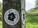
St Cuthbert's Way
Kirk Yetholm → Wooler
 Distance: 13.53 miles
Ascent: 707 metres
Duration: 4 hours 50 minutes
Scotland to England
« Not walked | Not walked »
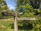
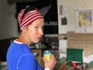
The first thing the B&B owner asked us last night was, "Do you know how you're leaving Kirk Yetholm?"
 This village may be the northern end of one of Britain's best known trails but it doesn't have particularly good transport links. What it does have though is another long distance path.
So today, a day after finishing the only National Trail that crosses into Scotland, we're embarking on the only one of Scotland's Great Trails that enters England — St Cuthbert's Way.
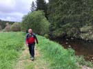
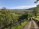
 The section from Kirk Yetholm to Wooler is right in the middle of St Cuthbert's Way, which runs from Melrose to Lindisfarne. It follows the Pennine Way south for a couple of miles before heading east at the border.
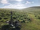
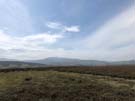
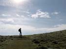
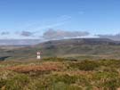
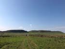
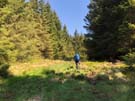
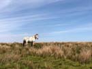
The rest of the walk was across moorland and along gentle valleys in the shadow of the Cheviot: a perfect way to wind down after a week of heavy walking.
We head home tomorrow, but we'll be back to cross the border again soon. After all, we may have nearly completed the National Trails of England and Wales, but Scotland has twenty-nine Great Trails for us to explore.
Thursday, 24 May 2018
Pennine Way
Windy Gyle → Kirk Yetholm
 Distance: 15.12 miles
Ascent: 761 metres
Duration: 5 hours 21 minutes
Journey's end
« Not walked | Not walked »
 We said a sad goodbye to our temporary companions this morning and headed off in the minibus to begin our final walk of the Pennine Way. The bus route took us along the military road, in places still wreathed in the overnight mist, back to Trows farm, where we started the long climb back up to Windy Gyle. Low cloud shrouded the valleys to the north, a fitting symmetry to our first walk on The Way when we left Edale in September.
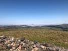
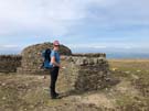
The lumpen mass of The Cheviot is on a spur off the main route of the Pennine Way, but it seemed churlish to not reach its summit. You don't do this for the views: the hill's upper reaches form a gentle dome that obscures the vista in all directions. Back on the main ridge there's plenty to be seen, especially the spectacular gully of Hen Hole.
Before we knew it we were crossing the border for the last time, although the path still had a few tricks up its sleeve. Lazy map-reading meant that I'd assumed today's walk was "up to The Cheviot, then a long descent to the end". That's not what we got; the high-level route continues a switchback across summits and bealachs - going up and over White Hill is particularly cruel - before finally reaching the road just outside Kirk Yetholm.
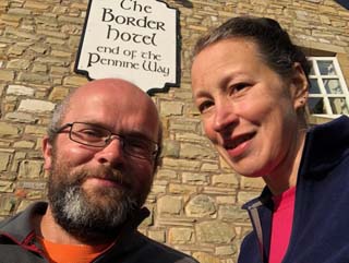
From the road we reached the village very quickly, and in the village: the Border Hotel. There's a book kept behind the bar for Pennine Way walkers to record their completion, and a reward of a free half pint of beer and a certificate. While we drank we noted with pleasure our friends' signatures and comments with just a hint of sadness that we'll not meet up again.
Wednesday, 23 May 2018
Pennine Way
Byrness → Windy Gyle
 Distance: 13.00 miles
Ascent: 880 metres
Duration: 4 hours 54 minutes
Walking to Scotland ... again
« Not walked | Not walked »
On the previous occasion that our walking took us across the border to Scotland we were accompanied by family and were celebrating the end of a 3,000 mile journey around the coast of England and Wales. Today's crossing was appropriately lower key, given that we've a much smaller distance under our belt this time.
 Did I suggest a singular crossing? We actually passed from one country to another five times today, but didn't once see a sign indicating this. In fact, on at least one occasion the border wasn't visible on the ground at all — not even accompanied by the low "border fence" that we walked alongside for much of the day.
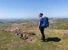
 From Byrness we started our traverse of the Cheviot range of hills. Every minute was absolutely glorious, with spectacular 360 degree views almost every step of the way.
There are no settlements between Byrness and Kirk Yetholm, but the 28 mile distance the Pennine Way takes is a little too much to complete in a single stretch. (And with views like this, why rush?) The best solution is to stay at the Forest View Walkers' Inn in Byrness, which offers a pick-up service halfway through the range, thus allowing wayfarers to have a day with a lighter pack.
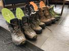
 Forest View is pretty much the only place to stay in Byrness, so it collects Pennine Way walkers into an informal community. It's a former youth hostel, bought by the neighbours when the YHA withdrew. Colin gladly clean and dry your boots before you even realise what's happening, while Joyce prepares a filling home-cooked dinner; soon everyone is gathered in the lounge chatting about their day's walk. It's a delightfully old-fashioned way to connect with people, and a brilliant way to share knowledge and experiences with kindred walkers. (Tonight we've met up with a couple we first saw in Twice Brewed, and then again this morning in Bellingham.)
While chatting with Joyce this morning I happened to mention that I quite like haggis. By the time she'd collected us from the path in her minibus she'd visited the butcher in Hawick to ensure a "special" of Haggis, Neeps and Tatties was on the menu tonight. It's that kind of place.
Forest View is on the market at the moment, but Joyce and Colin insist that they'll only sell to people who'll ensure this unique place retains its flare. Fancy a change of lifestyle? If only it was the other side of the border we'd be sorely tempted.
Tuesday, 22 May 2018
Pennine Way
Bellingham → Byrness
 Distance: 15.54 miles
Ascent: 648 metres
Duration: 5 hours 48 minutes
Into the forest
« Not walked | Not walked »
 The weather changed overnight, and we began the day under thick grey clouds, a stiff breeze and lower temperatures. The dark sky made a fitting backdrop to an early climb up onto the heather moorland above Hareshaw House. The ground underfoot became increasingly wet and soft as we moved north, with the bog cotton, moss and heather joined by bilberry and the occasional stunted spruce. Looking back from Padon Hill, there was a distant outline on the horizon of what we thought was Cross Fell, a reminder of the distance that we've travelled this week.
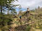 The open moorland soon gave way to commercial forestry, some of which had recently been felled. It's strange to think of this as harvesting — we're much more familiar with standard crops such as wheat or oil seed rape — but it's the reason that the forest exists at all. Walking along the stony access track, we didn't get to experience being in the dense planting, although a couple of short deviations from the road took us along wooded paths speckled with wild flowers and short birches.
 The onward path takes a lovely route alongside the River Rede, emerging onto the A68 at St Francis' church near Byrness (which, we've learned, is pronounced Burr-ness, and while we're at it Bellingham has a soft 'g': Bell-in-jum). It's well worth stopping to look inside the church — there's a monument and commemorative stained glass window to the men, women and children who died during the building of the nearby Catcleugh Reservoir which supplies drinking water to Tyneside. The idea that children lost their lives as a result of industrial accidents, as recently as the beginning of the 20th century, hardly bears thinking about. As much as this is a beautiful landscape, it's also had a history of hard, unforgiving labour.
Notes for future walkers:
- Avoid the worst of the boggy bits and the fallen trees by turning west just before the trees at NY 814 936, then following the minor road north past Gibshiel into the forest, joining up with the formal route again at NY 799 955.
- Although the guidebooks recommend avoiding the footpath detours off the track through the forest, we found both to be quite delightful.
Monday, 21 May 2018
Pennine Way
Rapishaw Gap → Bellingham
 Distance: 13.26 miles
Ascent: 447 metres
Duration: 5 hours 10 minutes
The Pictish lands
« Not walked | Not walked »
So often "Hadrian's Wall" is used as a convenient shorthand for the England/Scotland border. Even politicians have confused the two as equivalent. The Pennine Way is clear that they're not the same thing. We may have crossed the wall into the land of the Picts today, but it'll take us nearly three days before we finish a walk in Scotland.
 Immediately north of the wall is a large expanse of moorland. Looking south from there the Whin Sill is an impressive natural defence, topped by the dark line of Hadrian's Wall, its north face in shadow.
 Today's walk alternated between moorland and forest. Tomorrow will be a similar story. In the early part of the 20th century the wild land here was artificially planted with spruce trees to create Europe's largest man-made forest, providing the United Kingdom with a sufficient supply of wood should it be required in a future Great War. It's an odd history, but one we were grateful for as the trees provided shade from the unrelenting sun. The only downside to the shelter of the trees was the slightly softer, wetter ground; picking a route around marshy mud brought back memories of our walks on the earlier sections of the Way last year, where this was the frustrating norm.
 At Horneysteads Farm we were grateful for another intervention: the owner keeps a barn unlocked as a "walkers' pit stop", with toilet, kettle, chairs, outdoor magazines and a well stocked fridge of goodies in exchange for donations. We've left the crowds behind, and are relying on the generosity of strangers. It's a wonderful thing.
Notes for future walkers:
- If you're starting at The Sill and want to avoid the worst of the rollercoaster of Hadrian's Wall Path, follow the line of the old Roman Military Way instead. You can pick it up just south of Peel Bothy where the road running north from The Sill turns left. It took us a little under an hour to get to Rapishaw Gap from The Sill on this route.
Sunday, 20 May 2018
Pennine Way
Greenhead → Rapishaw Gap
 Distance: 9.17 miles
Ascent: 681 metres
Duration: 3 hours 27 minutes
The Wall
« Not walked | Not walked »
 We made no progress north today. Instead we walked east along The Wall, you know: Hadrian's one. It really exists. Somehow we've lived on our island all this time without witnessing first hand its most famous archaeological site.
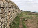
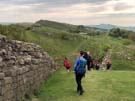 From Greenhead to Rapishaw Gap (just shy of Cuddy's Crags) the Pennine Way follows the line of Hadrian's Wall as it relentlessly pursues its journey from coast to coast, rolling over hills and clefts without diversion. The best preserved sections of the wall are along this stretch, and were being enjoyed today by an eclectic mix of people: Pennine Way walkers like us, other long distance wayfarers on the coincident Hadrian's Wall Path, day trippers, foreign tourists, dog walkers, rock climbers and those participating in a British Heart Foundation charity walk.
Where the Pennine Way leaves the wall we bumped into a fellow walker who has been on the same schedule as us for the past three days. Unlike us though, she's pushing on to Bellingham tonight and will finish the trail a whole two days ahead of us. With so much to see we're glad to have a shorter day today, but we'll miss comparing notes with our occasional companion.
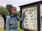
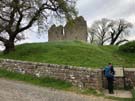
 Instead of continuing on the Way we ended this knee-straining, undulating, historical pilgrimage with a visit to Housesteads Roman Fort, a small township built against the wall, which had been home to a garrison of 800 soldiers. It's well worth a visit to get a sense of how people lived and survived in this bleak frontier landscape. Then on the way to the new Youth Hostel at Twice Brewed we visited Vindolanda, another Roman settlement -- this one predating the wall. There's much to see at both sites and we didn't do either justice. We'll have to come back.
But the Wall is really the star today, in all its splendour. From the too-frequently photographed Sycamore Gap, to the little sections where the only hint of masonry was an unusually linear earthen mound, it's amazing that any of this 2,000 year-old structure survives at all.
Notes for future walkers:
- If you're going to repeat our exact walk, we recommend stopping for lunch at Vindolanda (where there's a decent-looking café) rather than Housesteads (where the best you'll get is a pre-packed pasty).
- To walk to Vindolanda from Housesteads, take the track running south-west from Housesteads museum. Where the track reaches the B6318, turn right briefly before picking up a bridleway on the opposite side of the road. Note that most maps show this bridleway to the east of the track, not west. Follow the bridleway to East Crindledykes farm, then take its access track to a minor road. Turn right on the road, then take the second road on the right which leads directly to Vindolanda's main museum.
- From Vindolanda to The Sill, leave the site at the opposite end, follow the road to a t-junction then turn right.
Saturday, 19 May 2018
Pennine Way
Alston → Greenhead
 Distance: 17.08 miles
Ascent: 633 metres
Duration: 6 hours 26 minutes
The last of the Pennines
« Not walked | Not walked »
One of the guide books that we're using warned that today could be 'your least favourite day' on the Pennine Way. This morning beneath blue, cloudless skies and a shining sun, we were ready to prove the author wrong.
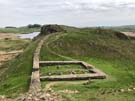
 Starting out over pleasant farmland, we soon passed the earthworks of Whitley Castle, a Roman fort. A drystone wall now runs through the middle of this impressive structure, but it's still possible to see the multiple ridges of its fortified banks. If we'd had more time (and weren't so close to the start of the walk) it would have been worth taking more time to explore, but other Roman ruins were calling us onwards.
 Unlike some of the previous sections of the walk, there was a lot of careful route-finding today, which contributed to a feeling that we were putting a lot of energy into not making much progress. The path took a series of twists and turns as it took us under a pair of viaducts, back alongside the River South Tyne, and up and down over more pasture, before finally meeting moorland again at Lambley Common. Here, the landscape changed, becoming the open, rushy ground that we've grown used to, although considerably drier and less boggy than we expected. At times the path wasn't visible on the ground at all, and we just had to aim in a rough general direction
 Standing on Blenkinsopp Common, with the wind blowing through the parched grasses and the 8-bit piping of the lapwings overhead, we could just about see the line of what will define tomorrow's walk: Hadrian's Wall. It felt as though we'd left the Pennines behind and finally moved into border country.
(Side note: another benefit of being well away from urban development was hearing a cuckoo, as we approached Haltwhistle Golf Club. It made us aware of just how long it's been since we heard one around Maidenhead.)
Friday, 18 May 2018
Pennine Way
Dufton → Alston
 Distance: 20.04 miles
Ascent: 1056 metres
Duration: 7 hours 26 minutes
Settling an old score
« Not walked | Not walked »
A combination of good weather, leave allowance and determination means that seven months after we reluctantly called time on our previous effort, we're back on the Pennine Way. And what a way to start: the longest and potentially toughest section of the Way.
 Both of our guidebooks describe today's section over Cross Fell with foreboding, highlighting its potential difficulties with harsh weather, tricky navigation and energy-sapping climbs. Thankfully, after a cold night today began with clear blue skies and light winds, and as we made our way out of Dufton the tops of the fells were clear and cloudless. It was a good omen.
The route climbs steadily, over Knock Fell with its square cairn, on to Great Dun Fell with the curious golfball radar station. We had the route to ourselves, with just the rabbits, curlews and lapwings for company.
Cross Fell, the looming plateau, had been in sight for most of the morning but ascending to it was mostly straightforward (follow the numerous cairns). We're aware that we caught it on one of its rare peaceful days, but standing in the sun by the cross-shaped summit shelter it seemed that the fell's earlier name, Fiends Fell, was rather undeserved. The views from the summit were glorious, not least due to the absence of roads and buildings. This is a truly wild place.
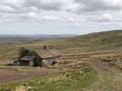 There's opportunities to go really wrong on descending from Cross Fell; even in clear daylight, we veered into wet ground, but once Greg's Hut came into view we were able to navigate towards it safely. We popped inside and felt extremely grateful to the Mountain Bothies Association for maintaining shelters like this; had we continued our walk in October it's highly likely that the availability of a place like Greg's Hut would literally have been life-saving.
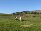
The rest of the descent followed a hard, stony path over grouse moorland for several miles, heading to sheltered Garrigill in the valley, surrounded by fields of sheep with young lambs, basking in the sun.
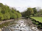 Almost the best part of the walk came last: the final few miles to Alston follow a lush, bucolic path along the River South Tyne, full of flowers and sweet meadow grass. It felt like a totally different walk, and a great way to end a day that redeemed our previous encounter with the Way.
One final note: if you're looking for somewhere to stay in Alston we highly recommend the Youth Hostel, if for no other reason than because you can enjoy watching red squirrels eating their dinner and breakfast outside while you enjoy yours.