Friday, 23 February 2018
Cotswold Way
Tormarton → Bath
 Distance: 17.51 miles
Ascent: 640 metres
Duration: 6 hours 22 minutes
Pilgrims' end
« Not walked | Not walked »
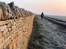
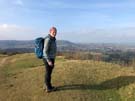
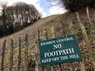
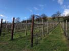
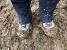
A sharp frost overnight had hardened the ground, giving us some respite from slithering around on muddy paths, but the air temperature was still freezing as we set off from Tormarton. The landscape had also changed, from grazing pasture to huge arable fields, and it was hard to see where the chalk escarpment had disappeared to.
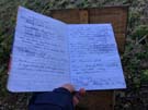 After crossing the busy motorway, the route turned south, passing more strip lynchets and erratic fields before skirting Dyrham Park, with its grand house just in view. Dyrham Wood, at the top of a gentle climb from the estate, has a message box for visitors to leave details of interesting sightings, but the real joy was in reading walkers' accounts of their journeys so far — some bounding with energy, others ... not.
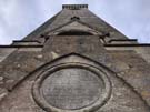
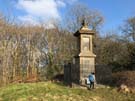 Beyond Cold Ashton, we spotted the first of a series of metal flagposts marking the site of the 1643 Battle of Lansdown. Although the Royalists eventually forced the defending Parliamentarian army to retreat, many were killed or wounded, including Sir Bevil Grenville, who had led a force of Cornish pikemen. Grenville's monument on the edge of the battle site is one of the oldest war memorials in the UK, a sad testament to a loved leader.
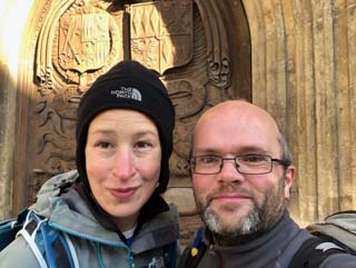
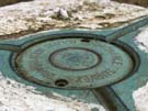
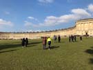 We could see Bath for some distance away, and as we gradually got closer to it, we sensed we were leaving the ancient countryside of hill forts and flinty chalk downland behind us. The final route into the city centre took us past fine Georgian houses and the famous Royal Crescent (with selfie-stick toting tourists), before we made our way to the official end marker outside the doors of Bath Abbey.
Amongst the crowds of people we felt slightly wistful for the peace of the open fields, but it was a fitting way to end this beautiful walk of contrasts.
Thursday, 22 February 2018
Cotswold Way
Wotton-under-Edge → Tormarton
 Distance: 16.47 miles
Ascent: 626 metres
Duration: 6 hours 19 minutes
Pastures and parkland
« Not walked | Not walked »
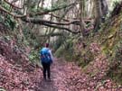
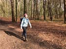
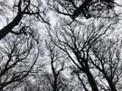
Setting off from Wooton, we took time to visit Hugh Perry's almshouses on Church Street; this quiet group of stone houses, standing around a small chapel, was built to house poor men and women, on the injunction that they "constantly attend upon the public prayers". Suitably chastened, we followed the Cotswold Way into farmland, walking along deep, overhung lanes filled with beech leaves.
This is ancient farming country; hillsides were marked with the ridged echos of old strip lynchets, evidence of a long history of use. This stretch of the Way also took us past the site of two mills, used for grain and fulling cloth, a reminder that the sheep grazing nearby would once have been part of a major local economy.
After a brief reminder of William Tyndale (the route passes Little Sodbury church, where Tyndale heard preaching that inspired him to start translating scripture into English) we continued through the extensive Iron Age hill fort of Sodbury Camp. Unlike some of the smaller forts along the path, Sodbury is well preserved, giving a sense of containment and safety inside the hefty walls.
 In complete contrast, Dodington Park is a mannered, clipped, Capability Brown estate, where trees and landscapes have been artfully managed to create an aesthetically desirable vista. The temptation to run wild across Sir James Dyson's immaculate lawn was strong, but we resisted, heading out to the untamed woodland beyond.
Wednesday, 21 February 2018
Cotswold Way
King's Stanley → Wotton-under-Edge
 Distance: 16.21 miles
Ascent: 944 metres
Duration: 6 hours 4 minutes
A meeting with Tyndale
« Not walked | Not walked »
 Much of today's walk continued along the clearly-defined chalk escarpment, peppered with the remains of tumuli and long barrows, and old quarry workings. Nympsfield barrow was surprisingly extensive, with an impressive height that would have taken skill and effort to build. The even larger Uleybury hill fort was well worth walking around to appreciate the massive earthworks built by its founders.
 The path took us steeply over the quarry-marked Cam Long Down, dropping briefly into the busy market town of Dursley, before another strenuous climb to reach the top of Stinchcombe Hill. There's a cheat's option of walking across the neck of this high ground, but we walked around the edge of the plateau, taking in the view of the Severn bridges and the distant hills to the west.
 The Tyndale Monument at North Nibley was also very clear on the horizon — a graceful tower tucked amongst trees on the hillside. Built in 1866 in the village of his birth, it commemorates William Tyndale's work translating the Bible into English, for which he was burned at the stake as a heretic. In the 500th year of the Protestant Reformation it felt especially appropriate to visit.
Notes for future walkers:
- Our guide book shows a direct route to the Tyndale Monument but the path has since been diverted; where the path leaves the road just south of North Nibley, follow the bridleway to SO 744 957 before turning back to rejoin the main Cotswold Way. The diversion is signposted on the ground.
Tuesday, 20 February 2018
Cotswold Way
Birdlip → King's Stanley
 Distance: 17.13 miles
Ascent: 730 metres
Duration: 6 hours 11 minutes
Like a rolling cheese
« Not walked | Not walked »
 The beginning stages of today's walk took us through more deciduous woodland, in clearer weather than we'd had yesterday. A very pleasant wander along a gently-climbing woodland track eventually brought us out to the foot of Cooper's Hill, famous for the annual cheese-rolling race. It's much smaller, and steeper, than either of us imagined. Thankfully, rather than crawling straight up the face of the hill, the route zigzags around the back of the hill to gain the top of the escarpment. Standing at the top — with a cheese-roller's-eye-view of the slope — we could only imagine the bravado needed to attempt the chaotic run back down to the bottom. It wouldn't be pretty.
 Much of today's walk was through quiet woodland, with wild arum, wood violets and ransoms already showing fresh green leaves. We'd seen gleaming white clumps of snowdrops amongst the remains of tumbled-down stone walls, too, so it was slightly ironic to watch a stream of traffic being marshalled into the grounds of Painswick House, which was advertising its own snowdrop display, presumably at a cost. We stopped in Painswick, a beautifully-preserved stone-built town, for a very welcome coffee.
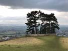
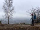
 Climbing once again to the chalk ridge, the best views of the day were at Haresfield Beacon, where the path takes a circuit of the Iron Age hill fort known as The Bulwarks. The Severn plain and the distant Black Mountains were visible from this airy promontory, making up for previous murky horizons, before we decended again to meet the canal and mill building on the edge of Stroud.
Monday, 19 February 2018
Cotswold Way
Dowdeswell → Birdlip
 Distance: 10.96 miles
Ascent: 523 metres
Duration: 4 hours 19 minutes
Cheltenham and Gloucester
« Not walked | Not walked »
 Heavy rain passed overnight, turning much of today's route into thick, claggy mud. It left behind a low cloud which muffled all views. Despite the mizzle we managed to see the Devil's Chimney, an interesting rock stack left behind by quarrymen on Leckhampton Hill.
 Later on we also caught a glimpse of Cheltenham, with GCHQ's "doughnut" offices just visible (though not mentioned on the toposcope). Another view claimed to show Gloucester Cathedral, but we couldn't make out a thing.
 Mostly though, we've been walking in woodland, slowly making our way around the hills that fringe these two towns. On such a dreary day it's no surprise that the highlight was lunch. We can highly recommend the café at Crickley Hill nature reserve for jacket potatoes and cake.
Notes for future walkers:
- Once again our guidebook is out-of-date. South of the A40 the Cotswold Way now climbs almost as far as the A436 before turning west at SO 990 186, rather than passing through the centre of Lineover Wood.
- The A417 by the Air Balloon pub at SO 935 161 is the most dangerous road crossing we've ever had to make: traffic approaches the roundabout in two lanes at insane speed, and there's a blind corner to make it even trickier. Good luck.
Sunday, 18 February 2018
Cotswold Way
Winchcombe → Dowdeswell
 Distance: 11.69 miles
Ascent: 567 metres
Duration: 4 hours 27 minutes
A familiar but distant hill
« Not walked | Not walked »
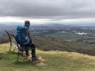
For the fifteen years Greenbelt was held at Cheltenham Racecourse I looked up at the stony cliffs of Cleeve Hill and wondered what the view was like from there, looking back at the town. We finally found out. Today's walk has been a long zig-zag up and over the hill, finally dropping down to the A40 just east of Cheltenham.
 There's been plenty to see, including the magnificent ancient burial tumulus of Belas Knap, the impressive Jacobean opulence of Postlip Hall (now a cohousing community), and — audible for a good half mile before we reached them — a group of men (and it was mainly men) driving Landrovers around an improbable course in a disused quarry. We've also seen rather more mud than we'd have liked.
Notes for future walkers:
- Since our guidebook was published the path has been re-routed east of Cleeve Hill. After passing Belas Knapp, instead of continuing on to Wontley Farm the path now turns right (north-west) at SP 011 250 along a field edge, then downhill through Breakheart Plantation to meet a road at SP 009 262. It then heads north-west again, turning left in front of Postlip Hall and picks up the bridleway around the left and back of the hall to SO 999 272 before running east to the clubhouse at Cleeve Hill.
Saturday, 17 February 2018
Cotswold Way
Broadway → Winchcombe
 Distance: 12.24 miles
Ascent: 505 metres
Duration: 4 hours 25 minutes
Back on the horse
« Not walked | Not walked »
We're back on the Cotswold Way after a couple of months' break. At one point we passed a man struggling to get back on his horse after passing through a gate; sometimes resuming a long walk feels like that.
 Leaving Broadway behind us, we slowly ascended to the escarpment, a prominent feature that we'll keep company over the next few days. The Cotswold escarpment is marked with evidence of earlier settlers: the route passes the remains of the ramparts of Shenberrow Camp, one of several Neolithic Hill forts that made the most of the excellent defensive position offered by the limestone cliff. The same golden limestone features in many of the older Cotswold buildings, including tiny estate village of Stanway, with its grandiose gateway and hall.
A steep climb back up the escarpment from Wood Stanway, over increasingly muddy fields, gave us an exhilarating view of the Malvern hills across the Vale of Evesham, before we turned west to circle the outside of the Beckbury Camp earthworks. We enjoyed the birdsong filling the beech woods on the decent down to the ruined Hailes Abbey, before squelching over fields to meet the sunken lane into Winchcombe.