Friday, 7 June 2013
Coastwalk
Bridlington → Filey
 Distance: 19.22 miles
Ascent: 405 metres
Duration: 6 hours 21 minutes
Footpaths
« Hornsea | Scarborough »
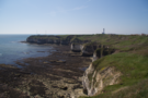
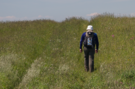
 At last we've spent a day without trespassing! Filey and Bridlington are separated by Flamborough Head, the last big headland we'll meet before Scotland. Around the edge, a recreational path — The Headland Way — seems to be a popular route for walkers and runners alike. ("Welcome to e'Yorks!" said an elderly man as he sprinted past.)
The southern cliffs are beautiful, with a clear horizontal boundary where the bolder clay that we've been walking on all week is being pushed up and out of the way by chalk. The landscape has really changed, and there's a strong sense that the wide sandy beaches that have been with us since The Wash are now in the past. Ahead it's all headlands and hills!
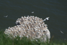 The cliffs — especially on the northern side — were packed with birds, whose constant circling and crying was almost as evocative as the ammonia tang emanating from their nests. At an RSPB reserve a Dutch volunteer encouraged us to use his telescope to view a gannet chick on a sea stack.
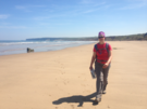
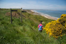 Further along, just beyond the East/North Riding border the public footpath heads inland, and two large holiday parks would present obstacles for anyone wanting to continue on the clifftops, but we dropped onto the beach by a way-marked permitted path and enjoyed the final six miles into Filey on the sand.
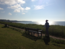
 The sun's been out today, which brings me to a final warning. Looking at my shoulder this evening it would appear the white stripes in my Helly Hansen LIFA top aren't as good at blocking UV as the blue stripes. Still, it makes for an interesting effect.
Notes for future walkers:
- The walk around Flambrough Head itself is easy and a public right of way.
- At Speeton Cliffs (TA 153 753), instead of following the public footpath inland, we took a steep signposted path which dropped us on the beach at TA 154 754.
- We followed the beach the rest of the way to Filey, although suspect that this will not be possible for about two hours each side of high tide.
- (Our backup plan was to find a route through the holiday parks at Reighton Sands and Primrose Valley. You can find site maps online easily enough; I suspect it would involve turning a blind eye to "residents only" signs.)