Sunday, 31 July 2016
Angels
Cashing in on Angels

The Scottish tourist industry certainly knows how to milk merchandising opportunities, whether it's "jocks' hats.
And although I enjoy whisky and depictions of angels, and I recognise "the angels' share" as a the correct term for the spirit lost due to evaporation during maturation, this souvenir glass angel containing an unknown yellowish liquid "not for consumption" is one piece of tat too many.
Friday, 29 July 2016
Extras
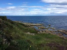
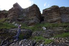
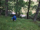
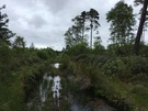
Sculptor's Cave
"Somewhere hereabouts," I wrote in March, "it's allegedly possible to drop down to a cave with 1,500 year-old Pictish carvings."
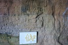
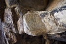
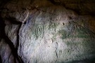
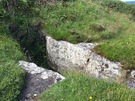
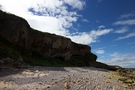
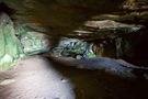
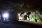
The soft sandstone of this part of the Moray coast is riddled with caves. The Sculptor's Cave is so-named because of the markings near its entrance that have been dated to about 500 AD. There's a notice near the entrance to help you distinguish the Pictish from the more recent vandalism. In the left-hand image, the markings depicted on the notice are at the top of the photograph. The Pictish markings in the right-hand image are the two concentric rectangles. The central image shows three adjacent ovals and an abstract flower. These are hidden on the ceiling at the entrance to the cave.
There's scant detail online about how to do it, so here I present how to get to Sculptor's Cave.
The cave can only be reached at low tide, so check the tide tables first. Since you'll be doing a little bit of clambering, make sure you've got appropriate footwear.
If you're driving, park on the B9040 at NJ 179 700, about a third of the way from Hopeman to Lossiemouth. There's sufficient space for three or four cars beside the track to the old coastguard lookout. Walk up to the lookout tower.
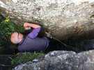
From the lookout tower at NJ 176 707, turn to face the sea. The cave is a little to the west of this point and below you, but to descend the cliffs you have to go east first. Ignore the Moray Coastal Way, and pick up the old coast path that's ahead of you. It soon bears right and passes a rock ledge on the left that provides a good vantage point to the slopes below. Just after the ledge look out for a gap in the gorse on the left; you should find a less distinct path that leads down to a level grassy area with a rocky cleft in the middle. (There are two routes down to this, approaching the 30cm-by-1m cleft from either side.)
The first of this next group of photos is taken from the old path; the rocky cleft is directly behind the foxglove flower in the middle of the picture. The central photo shows the cleft a little closer, and I took the right-most while standing directly in front of it. This is your way down.
The cleft is the top of a rock chimney (NJ 177 708, about 12m). Hanging on its western wall is a six-runged rope ladder. Test its weight and descend. The rocks at the bottom are slippery so watch out! Use a further bundle of ropes attached lower down to steady you onto the beach.
When you're on the beach, look back at where you've come from; you'll need to be able to find this on the way back. When we visited there was a handy green flag marking it.
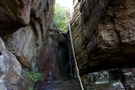
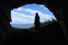
That's the difficult bit done! Now scramble over the rocks round the first small headland to the west. There's a fantastic huge cave here, but it's not the one you're looking for. Keep going to the western end of the next shingly cove. Sculptor's Cave is the double-entranced cave at the back of the beach (NJ 175 707).
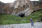
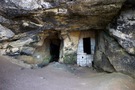
Visitors had left various bones, sticks and things on a large bolder at the back of the cave, but they're not significant. The carvings are all in the entrance passages.
Keep an eye on the time, and reverse your steps to get out.
As Jez said, there must be thousands of these types of places around the country. You just need to know that they're there and how to find them.
Thursday, 28 July 2016
Inverness, Loch Ness and the North East Highlands
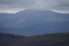
A Corbett
Can there be anywhere better than Ben Rinnes to prove that concentrating Scottish hillwalking on the Munros is a fool's errand?
 Distance: 4.97 miles
Ascent: 563 metres
Duration: 2 hours 44 minutes
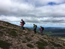
Walk 21: Ben Rinnes
We first set eyes upon Ben Rinnes back in March when it stood out as the snow-capped dominating the view to the south from the Moray coast.
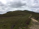
Climbing is easy — there's a good (although slightly rocky) track all the way up to the summit tor. And when you reach the top the views reward the climb. The whole of Moray is laid out before you, from the coast in the north to the edge of the Cairngorms in the west.
For years we've been focussing our walking on the coast, and I've been tempted to follow that with the Munros. The lesson of Ben Rinnes isn't that the other tick lists (Corbetts, Marilyns, Donalds, County Tops, etc.) should be sampled too, but that there is so much more of the country to explore.
Tuesday, 26 July 2016
Coastwalk
Nairn → Inverness
 Distance: 19.77 miles
Ascent: 150 metres
Duration: 5 hours 50 minutes
Year three complete
« Forres | Rosemarkie »
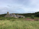
Every so often there's a walk like today's. Between Nairn and Inverness the coast walker is challenged by a military range, a vast derelict oil rig construction yard, busy pavement-less roads, and no obvious footpath.
The easiest thing to do would be to say it's impossible or pointless to try this stretch. Not us. We're completists. On the other hand today we were more interested in making progress than searching out the most coastal route with the attendant risk of having to backtrack at an impassable bog. We knew there was a better route to take but we didn't have the energy to discover it.
 So for all but the first three miles we were on roads today: A-roads, B-roads, minor roads and old roads. The worst was the A96, the major route east from Inverness. It was a case of don the fluorescent yellow jacket, keep an eye on the vehicles and march. On the whole drivers graciously gave us space, but few slowed down and the draught from some of the lorries was almost enough to sweep us off our feet.
The highlight was the section through Carse Wood, just east of Fort George. Here the pine trees towered high and rubbed their branches together with the creak of an old floorboard. A little further on wild raspberries lined the road, as populous as brambles elsewhere but a delightful change.
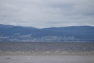 The wind sculpted the Moray Firth into choppy waves, and from the Fort we could see perhaps fifty people staring valiantly towards the water hoping to see an elusive dolphin or two. I'm sure we'll be the same when we get to Chanonry Point in two walks' time.
 For the final stretch we took to the old road that runs right along the coast starting at Milton of Culloden. It was a delightful change from the hectic traffic although the road stops rather abruptly when interrupted by the Aviemore to Inverness railway line. Scaling a fence, scrambling up a bank, across another fence and down a final bank to the A96 was a small price to pay and a somewhat exciting way to reach our destination of the A96/A9 interchange.
And with that, we've finished the third in our current five year coast walking plan. 2017 should see us reach John O'Groats; 2018 will take us to Cape Wrath. That gives us ten years to do the west coast of Scotland before our thirty-year walk is complete.
Notes for future walkers:
- Take your time. Find a better route than we did!
- West of Nairn we followed the coast past the third green at Nairn Golf Course before heading south across the course, where we picked up the track to Easter Denies and the A96.
- From Denies we went west on the A96, then the B9092 before turning right past Kebbuk Stone on a minor road through Carse Wood. At Baddock we turned right towards Fort George.
- Where the minor road meets the B9039 just east of Fort George we made straight for the beach and picked up an excellent footpath south through the shingle to Ardersier.
- From Ardersier we took the B9039 south to the A96 which we followed south-west to Milton of Culloden. Traffic was fast and busy along this stretch.
- There's a pavement alongside the A96 between Milton of Culloden and Inverness, but an alternative is to cross the railway at NH 710 470 and follow the old road south-east. There are a couple of opportunities to return to the A96 on footpaths but if you don't you'll need to scramble up the steep bank near NH 688 457.
Sunday, 24 July 2016
Coastwalk
Forres → Nairn
 Distance: 17.02 miles
Ascent: 92 metres
Duration: 5 hours 23 minutes
Culbin
« Findhorn | Inverness »
Forest. Rather a lot of forest.
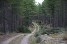
Perhaps 80% of this section is in the Culbin Forest, a vast expanse of trees planted between 1920 and 1960 to stabilise the dunes that had wiped out farming communities living hereabouts.
 You might think that would make for a boring, unvaried walk. Far from it! Although predominantly Scots and Corsican pines, the forest hosted a wealth of other life. Mushrooms gathered in clusters along the path; ants busied themselves moving needles to and fro; silvery-green lichen provided a blanket over the sand while broom, heather and gorse added colour. At one point we spotted a roe deer nibbling at the verdant undergrowth; sadly it was too quick to be photographed.
This being Scotland in July, there were biting insects too. Judging by the two huge lumps on my temple and crown these were not your regular midge! I spotted a tick on my hand too, but managed to dislodge her before she'd driven her jaw into my skin fully.
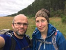
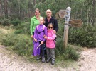 About halfway through the walk we met up with Jez, Jane, Miriam and Hannah. They previously joined us on the final coast walk in England. Hannah told me that "I walked from England to Scotland" featured in her "What I did during the holiday" writing that year.
Culbin Forest is a treasure. The Forestry Commission should be proud of what they've achieved here: a vast, well-managed estate with an poetic leaflet/map that almost demands a return visit.
Notes for future walkers:
- It seems highly likely there's a path along the western bank of the River Findhorn from Broom of Moy; we just took to the road, passing Moy House, Wellside Farm and Lake of Moy before entering the forest at NJ 018 633.
- There are myriad ways of traversing Culbin Forest, but once inside navigation can be tricky. The best way is to get the Forestry Commission map which shows numbered path junctions.
 After entering the forest we walked north-east to junction 4 (NJ 023 635), north-east again to junction 3 (NJ 026 638), north to junction 5 (024 644), north-west to junction 8 (003 639), west south-west to junctions 13 (NH 996 631), 14 (NH 981 623), 15 (NH 973 621) and 18 (NH 962 616). Then south south-west to junction 19 (959 612), north-west to junction 20 (NH 955 613), west to junction 21 (NH 938 600), south-west to junction 22 (NH 922 590) and again to junction 23 (NH 920 584). From junction 23 we started south-west again, but soon headed north-west on a narrow path through the trees before picking up a path on at the very edge of the forest.
- The path between junctions 18 and 19, and the one south-west of junction 23 were badly flooded; a better route may be possible.
Saturday, 23 July 2016
Munros
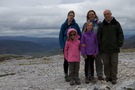
A good mountain to start on
On our way north to spend a week in Moray with Jez, Jane, Miriam and Hannah, what should we do to break up the long drive? How about introducing the girls to Munro bagging?
 Distance: 2.78 miles
Ascent: 285 metres
Duration: 1 hour 25 minutes
M281: Carn Aosda
The Cairnwell Munros are often derided as ugly, and boring. Not "good" Munros. Summits to get out of the way as quickly as possible when contemplating a round.
 I disagree. They may be amongst the lowest, they may be the easiest, but that's precisely what makes them an excellent choice for the first Munros to bag. We only had time for one today: Carn Aosda.
The view from the top was beautiful and expansive. I hope we'll be climbing more mountains together in the future. After all, there are another 283 to do.
Saturday, 9 July 2016
Gig
Manic Street Preachers
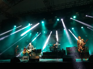
The Manics first burst into my consciousness in the early 90s, played at a chest-rattlingly high volume in our sixth form common room, and their era-defining output formed a soundtrack to my student life over the next decade. Everything Must Go became an anthem to a particularly sour break-up; If You Tolerate This articulated a growing political awareness. For many years, the Manics were the band that got away: one of the ones that I never quite got to see live.
Maybe that's why I was so pleased to finally get tickets to see them at the Eden Project; not the first place I'd think of for live music, but since we've been visiting on an annual basis, somewhere that I've also come to deeply love. And it was my birthday weekend, too; hardly a better way to celebrate.
We managed to end up right at the front of the crowd, pressed up close enough to see the persistent rain sparkling in the stage lights. You love us played as a thumping encore; I certainly do.
Saturday, 2 July 2016
Glyndŵr's Way
Meifod → Welshpool
 Distance: 12.43 miles
Ascent: 630 metres
Duration: 4 hours 7 minutes
Changing character
« Not walked | Not walked »
Much of Wales will have a headache this morning, if my experience at The Angel Inn in Welshpool is anything to go by. The national football team made their way to the quarter-finals of a major sporting event for the first time in decades, and while the sport wasn't rugby the beer and cheer flowed freely.
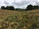
Just like yesterday, today's walk demonstrated a change in the landscape. The fields are no longer all dedicated to grazing, and when I came across my first barley and wheat crops I knew there'd be no more mountains to climb.
From the higher points on the walk the flattening of the landscape to the east was apparent. And in the middle, the familiar double-hump of the Breidden Hills marked where I knew the border with England lay.
Glyndŵr's Way ends firmly in Wales though: in a park beside the canal in Welshpool.
As I arrived the annual Coracle Regatta and Food Festival was just swinging into action, although I wasn't daring enough to try my hand in one of these ever-so-local lightweight vessels.
According to my records the Way has taken me across 141 miles of countryside, climbing a total of 7,500 metres over 44 hours of walking. It's been a tiring week, but I've thoroughly enjoyed getting a taste for this part of mid-Wales, wet-weather and all.
Notes for future walkers:
- There are a few diversions on this stretch, all well-marked on the ground.
- The most substantial was from the road at the foot of Graig Wood (SJ 176 084). Instead of crossing the fields at this point, the route now follows the minor road to SJ 174 083, then takes the path to SJ 177 077 where it crosses another road to continue to SJ 174 076.
- Watch out when you get to the roundabout on the outskirts of Welshpool: I ignored the map and headed into town on the B4381 instead of the A458, thus denying myself a triumphal entry!
Friday, 1 July 2016
Glyndŵr's Way
Llanddwyn → Meifod
 Distance: 16.11 miles
Ascent: 656 metres
Duration: 5 hours 8 minutes
Slow down
« Not walked | Not walked »
Slow down. Hold still.
 My chauffeur service departed this morning so I'm on my own for the final two days of the walk. Dependent on making my own arrangements, I've changed pace dramatically. I still started off early, but booked a taxi to pick me up after a sensible distance and left plenty of time. Even though my walking pace has been much slower today, I still arrived with ninety minutes spare.
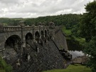
The character of today's walk is unlike any previous section on Glyndŵr's Way: it's all downhill, following the Afon Efyrnwy from the woods beneath the dam (where I startled a newly fledged starling who was hopping about the path). The route wends its way through hamlets and villages with beautiful poetic names: Abertridwr, Pont Llogel, Dolanog, Pont Robert and Meifod.
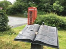 The central part of this route is shared with the Ann Griffiths Walk: a way marked trail celebrating the life of the 18th century hymn writer. In each village a charming open book sculpture shows a map of the route along with bronze leaves, chapels and wildlife.
 The wildlife hasn't always been pleasing today though. On occasions this week I've picked up the scent of fungi in the woods, reminiscent of my childhood. But in the woods beside the river today on two occasions a similar fragrance was decay of another kind: lambs who'd strayed too far from the rest of the flock. (There are probably metaphors a-plenty here.)
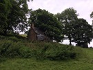
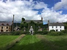
That aside, it's been an enjoyable day. So here I am, in the churchyard of St Tsilio, sitting on a bench, enjoying the warmth of the sun, the breeze drying out my boots, and gathering my thoughts about a week of walking.