Thursday, 30 June 2016
Glyndŵr's Way
Cemmaes Road → Llanddwyn
 Distance: 25.89 miles
Ascent: 1436 metres
Duration: 7 hours 51 minutes
Catch-up
« Not walked | Not walked »
Yesterday's foreshortened walk meant that I'd lost the extra half day's walking I'd gained earlier in the week. The opportunity to reach Welshpool by the weekend was slipping away. As I lay in bed last night I hatched a plan: with one huge day today, I could be back on track.
I started early and walked fast. From the valley below, the rattling of the familiar train from Aberystwyth greeted all who were awake to hear it. There was no time to admire St Mary's Church in Llanbrynmair or the old chapel that my guide book raved about.
 There was time however, to engage in a rare conversation. In the Dyfnant Forest I met Martin, the first Glyndŵr's Way walker I'd met since the campers on day two. His accent marked him out as from Central Europe, but I didn't ask where. He'd walked half the Way with his wife and children seventeen years ago and was now back to complete it although like me the torrents had hit his plans, leaving him to spend two days drying off in Llanbrynmair. I hope he felt welcome in the village. "I hope," I would have liked to say, "you will always feel welcome in our country." (Some of the rhetoric espoused on television these past few weeks would imply otherwise.)
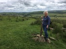 Mum had walked up to meet me at Eithin-llwyn, supplied me with fruit and then caught me again at Llangadfan although this time she directed me at the wonderful home baking on sale in the village shop.
 Suitably refueled I continued, and before too long saw in the distance the water of Llyn Efyrnwy. There's a photograph of Mum and Dad here on their honeymoon. It was December 1967. Foot and Mouth control had closed the countryside so instead of walking they drove to a different body of water each day.
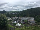
The lake was one of the first built by English municipalities to provide a reliable water supply. The flooding of valleys and eviction of communities in one country for the benefit of another ring echoes of the independence and EU debates. Llanddwyn village — now nestled beneath the dam — was reconstructed after being moved here from the valley just before flooding. There's little mention of this in the Vrynwy Experience exhibition.
Notes for future walkers:
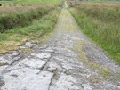
- Rather than visit Llanbrynmair, the path now runs directly from Bryn-aire-uchaf (SH 898 040) to Clegyrddwr (SH 901 038), which it routes around on the north before joining the minor road from Pandy-rhiw-Saeson and heading into the fields once more at SH 901 032. While the start of this detour was well marked, I lost the trail between the two farms.
- The last bit of the path through the plantation at SH 941 066 was very wet underfoot, and the land across to the side of Eithin-llwyn (SH 946 063) was similarly boggy, as was the north-eastern side of Pen Coed (SH 996 092).
Wednesday, 29 June 2016
Severn Way
Newtown → Abermule
 Distance: 4.90 miles
Ascent: 15 metres
Duration: 1 hour 9 minutes
Llwybr Hafren
« Not walked | Not walked »
 Keen to walk a little further after aborting this morning, I settled on an easy route: a taste of the Severn Way, following the towpath of the old Montgomery Canal.
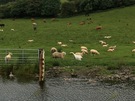
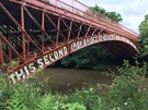
It was a delight. When driving regularly to and from Aberystwyth a decade ago I'd often noticed the canal, so I was really pleased to see this obsolescent highway close up. Beech boughs bent to kiss the surface of the water, swans shepherded sheep away from their cygnets, and the braggadocious Brynderwen Bridge proudly declared itself to be the "Second iron bridge constructed in the county of Montgomery".
I think I'll be back for the rest of the Severn another year.
Glyndŵr's Way
Machynlleth → Cemmaes Road
 Distance: 9.01 miles
Ascent: 560 metres
Duration: 2 hours 48 minutes
Uncomfortably numb
« Not walked | Not walked »
I took just two photographs on this walk. That should give you a clue about the conditions. The first — taken right at the start outside the Co-op on Maengwyn Street — is of Edible Mach: a perfectly placed herb garden from which shoppers are encouraged to help themselves.
Just after leaving Penegoes I dared take the phone out of its protective case for the second photo. The rain had been relentless since I set out and even in full waterproofs I could feel my temperature dropping as the wind drove it through to my skin, evaporating the little warmth I had.
 Relieved that safety was in sight, I left Cefn Coch with the trail to my first rendezvous at Cemmaes Road. I'd hoped to walk further but it would have been foolish to continue. Gutted, I reconciled myself with the inevitable and sat quietly in the car.
On this evening's national news we heard of 29 DofE participants on the Brecon Beacons who'd not had such an easy escape. I made the right decision.
Tuesday, 28 June 2016
Glyndŵr's Way
Clywedog Dam → Machynlleth
 Distance: 23.47 miles
Ascent: 1311 metres
Duration: 7 hours
Over the mountains to the sea
« Not walked | Not walked »
The guidebook I've been following this week splits Glyndŵr's Way into fifteen chapters of approximately 7 miles each, so for the first couple of days the plan was to walk two chapters per day. Between Llanidloes and Machynlleth, things get trickier, with three consecutive 9-mile chapters dividing this part of the walk at almost unidentifiable road junctions. After yesterday's head start, I realised that it would be possible to push all the way to Mach today but it would be another long one, and once again the weather forecast looked… Welsh.
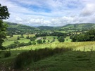
Having said all that, this is the key walk to Glyndŵr's Way. It's the day the route crosses the back of the Cambrian Mountains, climbing to the highest point on the trail before a jaw-droppingly beautiful descent towards the sea.
 I didn't notice the Roman fortlet at Penycrocbren but the ancient drover's road that took me across the moor bore very visible scars of hundreds of years of cartwheels, deep grooves gouged into the rock. Leaving the fort behind, I could hear the infant Clywedog cascading through the deep cleft that it has cut. From the pass beyond the river's source, Pumlumon was visible to the south and ahead, my book promised glimpses of Cardigan Bay, although all I could see was the advancing rain.
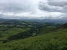 Even in this weather I couldn't help but smile as I took the path down from Bwlch y Graig on the shoulders of Foel Fadian into the wooded cwm below. Slowly, the song of the skylarks, whose ascent had accompanied mine, gave way to the chattering of garden birds as the open moorland morphed into small paddocks and fields. I found myself stopping regularly to take photographs but none do the scene justice.
 It was another 9 miles from the valley floor to Mach; a wet, exhausting trek though my spirits were lifted slightly when the Wales Coast Path joined hands with Glyndŵr's Way for the final approach. (Though on my coastwalk I cheekily crossed the Dyfi further downstream.)
Notes for future walkers:
- Near SN 888 883 a diversion takes the path across the Nant Croes sooner than shown on maps, climbing up the slopes of the north bank to pick up a path at the foot of the next field.
- On the descent from Mynydd Du, be sure to veer left at SN 873 889 rather than follow the track on the right-hand side of the fence.
Monday, 27 June 2016
Glyndŵr's Way
Abbeycwmhir → Clywedog Dam
 Distance: 22.68 miles
Ascent: 1270 metres
Duration: 7 hours 10 minutes
Shifting Power
« Not walked | Not walked »
 The plan for today was to walk as far as Llanidloes, but having set off early (to avoid the promised rain), I reached the village at lunchtime and with clear skies overhead I decided to push on to the next obvious landmark. (Once again the benefits of having a willing support crew are clear.)
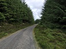
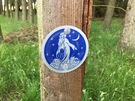 From Llanidloes, Glyndŵr's Way joins forces with the Severn Way for a mile or so, and a little longer with the Sarn Sabrina Walk, whose way marks — depicting a water nymph — led me in a roundabout way to finding an online recounting of the story I know as the Daughters of Pumlumon. I hadn't dreamt it after all!
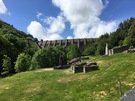 The changes of power in the country are clear today. From the abandoned Abbey near the start, to the stone by Llanidloes market hall upon which John Wesley stood to preach; from the disused Bryntail lead mine at the foot of the Clywedog Dam to the dozens of wind turbines looking down from the hills above Llandinam.
There's change on a micro level too: a house at Hengynwydd Fawr offered "Repairs: musical instruments and computers", an unlikely combination effortlessly capturing progress of technology. And then there's the national and international level: the caravan park at Newchapel flew the Welsh and European flags side by side, jolting me back into remembering the as yet unknown change ahead for our country.
Notes for future walkers:
- West of SO 044 719 the path via Cwmysgawen has been closed, so the Way is re-routed north along the minor road to SO 043 726 where it picks up the bridleway west towards Lower Esgair.
- At SN 930 869 a new diversion takes the Way off the B4518 and onto the rough scrubland of Penwar, rejoining the original route on the drive to Bryntail farm. Another smaller diversion a little later on takes the route around the farmyard to the north instead of through it; it's well signposted.
Sunday, 26 June 2016
Glyndŵr's Way
Felindre → Abbeycwmhir
 Distance: 15.84 miles
Ascent: 768 metres
Duration: 4 hours 54 minutes
Without transport
« Not walked | Not walked »
I didn't pass any other walkers yesterday, but this morning as I climbed out of Felindre I came across two men warming themselves up with mugs of coffee as they appreciated the view from their impromptu campsite above Cefn Wood.
Wild camping is the practical solution to the challenge of Glyndŵr's Way. It means carrying more, but frees you from the need to coordinate with public transport (or a friendly mother!).
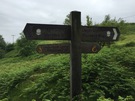
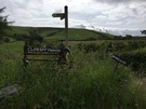
 Mum had parked one third of the way along the route today, and walked up the road to meet me above Llanbadarn-Fynydd. Route-finding is relatively easy on these sections of farm road, so long as you follow the waymarks in the correct direction. Unfortunately the frequent National Trail signposts name the path but tend to not mention the destination.
The rain held off until my last hour of walking, but by the time I reached Abbeycwmhir I was thoroughly soaked. East of the village the remains of the abbey were visible as low walls standing in the field beside the Clywedog Brook, but weren't interesting enough to entice me off the path for a closer look.
There's no bus to Abbeycwmhir, no mobile phone coverage and a pub that doesn't open on Sundays. It's not a good place to finish a walk if you're dependent on public transport. If you come here on your own, either plan to camp in the wild or hope that the phone box works.
Notes for future walkers:
- For the final part of the descent into Llanbadarn-Fynydd the official route leaves the minor road for a field-edge path, but it was so overgrown that it's clearly rarely used.
- The section from Llanbadarn-Fynydd over Moel Dod (SO 795 767) and Yr Allt (SO 078 751) is breathtaking; don't miss it!
- The route has been diverted slightly above Dyfaenor, now taking the direct route between SO 071 712 and SO 067 712.
Saturday, 25 June 2016
Glyndŵr's Way
Knighton → Felindre
 Distance: 15.65 miles
Ascent: 847 metres
Duration: 4 hours 49 minutes
Up and down
« Not walked | Not walked »
Having a week's holiday without Emma is a new thing for me, as is the alternative: Mum's come instead! She'll be chauffeur/support while I walk Glyndŵr's Way, Wales' most recently created National Trail. The Way joins two points on Offa's Dyke — Knighton and Welshpool — by way of a long detour to Machynlleth on the Dyfi estuary.
 Mid-Wales remains undiscovered territory for me, and an area that I remember Dad recommending. This week I hope to get a feel for these valleys and hills.
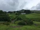
 Today's been very much about getting used to the landscape. Once Knighton is left behind, the route heads for the hills, crosses grazings and follows farm tracks down to the village of Llangunllo in the adjacent Lugg Valley. Then it's back up again, across the moor to return to the Teme Valley ten miles upstream from the start.
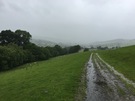
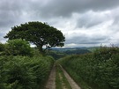
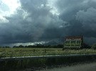
![]() The weather has been up and down too, with equal measures of glorious sunshine and cold, penetrating showers. Looking at the forecast I think this is likely to be the measure of the week ahead.
The weather has been up and down too, with equal measures of glorious sunshine and cold, penetrating showers. Looking at the forecast I think this is likely to be the measure of the week ahead.
Notes for future walkers:
- Since this is a National Trail, route-finding has been relatively easy: just follow the acorn signposts.
- Having said that, it could be better signed Cefn-suran. The route leaves the farmyard by a path through a copse, too small to appear on the map.
- At SO 206 726 keep an eye out for a gate off the track on the left before the big barns: the route continues through the gate rather than ahead by the pond.
Friday, 24 June 2016
Comment
Black clouds looming
My unbroken record of always voting for the losing option continues.
 Today that fact is rather more depressing than usual. A few weeks ago we saw posters beside the M40 that demanded we "Halt ze German advance! Vote Leave!"
If I hadn't been convinced before, the posters would have pushed me: I want to live in a country that welcomes people, not one that tries to restore old borders and fears. It's frustrating to see that so many people have been taken in by the rhetoric espoused by the Leave campaign.
Driving up the M40 this evening one of the posters now declared "Bye Bye EU. Praise the Lord! 23d June. Independence Day". The sky behind was black with cloud.
At Solas I came across an organisation whose slogan is "all of us first". Take me to that place.
Sunday, 19 June 2016
Solas
Solas 2016: Beyond Borders
Inspiring: Ian Brennan reminding us that everyone is a musician, and those who disagree are usually those promoting a western-pop monoculture.
Challenging: Alastair McIntosh retelling open conversations between a pacifist and military leaders.
Dazzling: BDY_PRTS — surely destined for great heights — delighting the audience with thumping pop and a magical avent-garde stage presence.
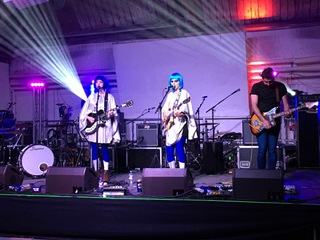
These are just a few highlights; amongst others I also caught old-favourites Andy Wightman, Marit and Rona, Stanley Odd, Karin Polwart. It's telling just how much of my cultural discovery now takes place in this field west of Perth.
And of course, the usual Solas serendipity was ever present (not just in the title of Sarah Rose Graber's wonderful wide-eyed single-handed show). The festival's scale and no-hassle welcome to all means that striking up conversations with strangers is very easy, and you're equally likely to find the person you're comparing notes about falafel with is a punter, festival organiser, main stage performer, volunteer or MSP.
My only sadness is that there was no reference to this week's murder of Jo Cox MP. Perhaps it's too recent for comment.
The festival ended with a performance by The Hazey Janes with Liz Lochead and Steve Kettley. With two of his children in the band, and one number about his funeral, Michael Marra's presence felt very near. So with a little time spare before our train home this morning I walked through South Inch park beneath the walls of Perth prison, seemingly the inspiration for Marra's song of optimism and hope, Letter from Perth.
I want to talk to the trees
check out the smell of the blossoms and the bloom.I would rock in your sweet and tender arms
if I wasn't doing time.
I have to get this message to you baby
it's a beautiful day and I feel fine.There's a light at the end of the tunnel,
I can see it peeking through.
Big Light must shine on someone,
may as well be me and you.
I find I'm listening to this more and more these days. In Liz Lockheed's words, "The light comes back. The light always comes back."