Tuesday, 28 June 2016
Glyndŵr's Way
Clywedog Dam → Machynlleth
 Distance: 23.47 miles
Ascent: 1311 metres
Duration: 7 hours
Over the mountains to the sea
« Not walked | Not walked »
The guidebook I've been following this week splits Glyndŵr's Way into fifteen chapters of approximately 7 miles each, so for the first couple of days the plan was to walk two chapters per day. Between Llanidloes and Machynlleth, things get trickier, with three consecutive 9-mile chapters dividing this part of the walk at almost unidentifiable road junctions. After yesterday's head start, I realised that it would be possible to push all the way to Mach today but it would be another long one, and once again the weather forecast looked… Welsh.
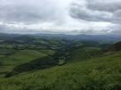
Having said all that, this is the key walk to Glyndŵr's Way. It's the day the route crosses the back of the Cambrian Mountains, climbing to the highest point on the trail before a jaw-droppingly beautiful descent towards the sea.
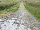 I didn't notice the Roman fortlet at Penycrocbren but the ancient drover's road that took me across the moor bore very visible scars of hundreds of years of cartwheels, deep grooves gouged into the rock. Leaving the fort behind, I could hear the infant Clywedog cascading through the deep cleft that it has cut. From the pass beyond the river's source, Pumlumon was visible to the south and ahead, my book promised glimpses of Cardigan Bay, although all I could see was the advancing rain.
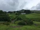
 Even in this weather I couldn't help but smile as I took the path down from Bwlch y Graig on the shoulders of Foel Fadian into the wooded cwm below. Slowly, the song of the skylarks, whose ascent had accompanied mine, gave way to the chattering of garden birds as the open moorland morphed into small paddocks and fields. I found myself stopping regularly to take photographs but none do the scene justice.
 It was another 9 miles from the valley floor to Mach; a wet, exhausting trek though my spirits were lifted slightly when the Wales Coast Path joined hands with Glyndŵr's Way for the final approach. (Though on my coastwalk I cheekily crossed the Dyfi further downstream.)
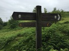
Notes for future walkers:
- Near SN 888 883 a diversion takes the path across the Nant Croes sooner than shown on maps, climbing up the slopes of the north bank to pick up a path at the foot of the next field.
- On the descent from Mynydd Du, be sure to veer left at SN 873 889 rather than follow the track on the right-hand side of the fence.