Friday, 22 September 2017
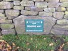
Pennine Way
Edale → Torside
 Distance: 15.63 miles
Ascent: 843 metres
Duration: 6 hours 55 minutes
Starting out
« Not walked | Not walked »
Here goes then: our first attempt at walking the UK's first National Trail. The Pennine Way was opened in 1965 and stretches for 250 miles from Derbyshire to the Scottish Borders. All being well we'll have a celebratory half pint in Kirk Yetholm two weeks tomorrow.
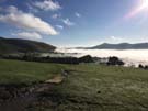 And it started so well! A low cloud inversion hung in the Hope valley as we climbed out of Edale. The village where the Way starts is currently hosting Bogfest 2017, which features an organised walk along half of our route today, so we set off early to avoid the crowds.
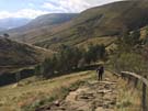 Almost immediately we climbed strenuously to the plateau of Kinder Scout, a hill that's taken on the mythical status as the birthplace of the Right to Roam movement eighty-five years ago. It was a further sixty-eight years before the Countryside and Rights of Way Act 2000 made a good start on the campaigned-for rights in England and Wales, but south of the border we're still way short of the world-leading access rights conferred by the Land Reform (Scotland) Act 2003. For a hill that has such significance in social history, we'd expected it to feel more significant in some way; in reality, the hard slog up its stony flank removed any romantic notions that we may have had.
The map suggested that after the initial climb, the remainder of the walk would be easy: a scamper along the plateau and then a descent into Torside.
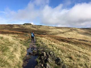
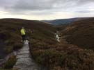
What we'd not bargained on is how complex that "along the top" walk would be. The Way is the least well waymarked of any National Trail we've seen so far and even when on the correct route, each step needs to be carefully considered since the ground is in equal parts peat bog and rough rocks. To be fair there are lengthy sections laid with flagstones too, but the other parts slowed our pace severely. On this stretch the comical call of the occasional grouse lifted our spirits slightly. What other animal quite literally shouts "quack"?
 Route finding is tricky for other reasons too. On top of Bleaklow Head there are very few visible landmarks and the ascending path is hidden in a deep cleft. It started to rain on this section, and the intermittent drizzle persisted for the rest of the walk.
The highlight of the lengthy descent at the day's end was a friendly black and white cat on the valley floor who had been patiently watching us make our way down, ready to welcome and love anyone who'd stop to say hello.
So there you have it. Fifteen miles down, two hundred and thirty-five to go. We have started; when will we finish?