Wednesday, 21 February 2018
Cotswold Way
King's Stanley → Wotton-under-Edge
 Distance: 16.21 miles
Ascent: 944 metres
Duration: 6 hours 4 minutes
A meeting with Tyndale
« Not walked | Not walked »
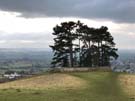
 Much of today's walk continued along the clearly-defined chalk escarpment, peppered with the remains of tumuli and long barrows, and old quarry workings. Nympsfield barrow was surprisingly extensive, with an impressive height that would have taken skill and effort to build. The even larger Uleybury hill fort was well worth walking around to appreciate the massive earthworks built by its founders.
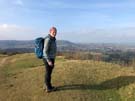 The path took us steeply over the quarry-marked Cam Long Down, dropping briefly into the busy market town of Dursley, before another strenuous climb to reach the top of Stinchcombe Hill. There's a cheat's option of walking across the neck of this high ground, but we walked around the edge of the plateau, taking in the view of the Severn bridges and the distant hills to the west.
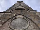 The Tyndale Monument at North Nibley was also very clear on the horizon — a graceful tower tucked amongst trees on the hillside. Built in 1866 in the village of his birth, it commemorates William Tyndale's work translating the Bible into English, for which he was burned at the stake as a heretic. In the 500th year of the Protestant Reformation it felt especially appropriate to visit.
Notes for future walkers:
- Our guide book shows a direct route to the Tyndale Monument but the path has since been diverted; where the path leaves the road just south of North Nibley, follow the bridleway to SO 744 957 before turning back to rejoin the main Cotswold Way. The diversion is signposted on the ground.