Tuesday, 26 July 2016
Coastwalk
Nairn → Inverness
 Distance: 19.77 miles
Ascent: 150 metres
Duration: 5 hours 50 minutes
Year three complete
« Forres | Rosemarkie »
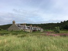
Every so often there's a walk like today's. Between Nairn and Inverness the coast walker is challenged by a military range, a vast derelict oil rig construction yard, busy pavement-less roads, and no obvious footpath.
The easiest thing to do would be to say it's impossible or pointless to try this stretch. Not us. We're completists. On the other hand today we were more interested in making progress than searching out the most coastal route with the attendant risk of having to backtrack at an impassable bog. We knew there was a better route to take but we didn't have the energy to discover it.
 So for all but the first three miles we were on roads today: A-roads, B-roads, minor roads and old roads. The worst was the A96, the major route east from Inverness. It was a case of don the fluorescent yellow jacket, keep an eye on the vehicles and march. On the whole drivers graciously gave us space, but few slowed down and the draught from some of the lorries was almost enough to sweep us off our feet.
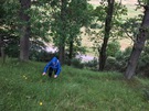
The highlight was the section through Carse Wood, just east of Fort George. Here the pine trees towered high and rubbed their branches together with the creak of an old floorboard. A little further on wild raspberries lined the road, as populous as brambles elsewhere but a delightful change.
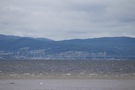 The wind sculpted the Moray Firth into choppy waves, and from the Fort we could see perhaps fifty people staring valiantly towards the water hoping to see an elusive dolphin or two. I'm sure we'll be the same when we get to Chanonry Point in two walks' time.
 For the final stretch we took to the old road that runs right along the coast starting at Milton of Culloden. It was a delightful change from the hectic traffic although the road stops rather abruptly when interrupted by the Aviemore to Inverness railway line. Scaling a fence, scrambling up a bank, across another fence and down a final bank to the A96 was a small price to pay and a somewhat exciting way to reach our destination of the A96/A9 interchange.
And with that, we've finished the third in our current five year coast walking plan. 2017 should see us reach John O'Groats; 2018 will take us to Cape Wrath. That gives us ten years to do the west coast of Scotland before our thirty-year walk is complete.
Notes for future walkers:
- Take your time. Find a better route than we did!
- West of Nairn we followed the coast past the third green at Nairn Golf Course before heading south across the course, where we picked up the track to Easter Denies and the A96.
- From Denies we went west on the A96, then the B9092 before turning right past Kebbuk Stone on a minor road through Carse Wood. At Baddock we turned right towards Fort George.
- Where the minor road meets the B9039 just east of Fort George we made straight for the beach and picked up an excellent footpath south through the shingle to Ardersier.
- From Ardersier we took the B9039 south to the A96 which we followed south-west to Milton of Culloden. Traffic was fast and busy along this stretch.
- There's a pavement alongside the A96 between Milton of Culloden and Inverness, but an alternative is to cross the railway at NH 710 470 and follow the old road south-east. There are a couple of opportunities to return to the A96 on footpaths but if you don't you'll need to scramble up the steep bank near NH 688 457.