Saturday, 10 September 2016
Coastwalk
Inverness → Rosemarkie
Distance: 18.73 miles
Ascent: 466 metres
Duration: 6 hours 19 minutes
The Black Isle
« Nairn | Cromarty »
Sometimes it's good to do something a little crazy, like travel 500 miles for a weekend of walking. And with the weather we've been having this past week it seems even more insane not to be outside.
The Black Isle is not an island. It's a peninsula sandwiched between two firths: Moray to the south and Cromarty to the north. The A9 Kessock Bridge not only took us onto the Black Isle but also took us across the Great Glen Fault. We're definitely in the far north now; we'll reach the other end of the fault in Fort William, in perhaps five years' time.
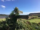 Occasional signposts reveal a recently developed "Black Isle Paths Network", but unfortunately it seems to have already fallen into disuse so route-finding has been more challenging than it ought to have been. One wrong turning resulted in us hopping a barbed wire fence to get out of a field, but I didn't move gracefully enough and tore my trouser leg.
On the other hand, it's been great to assert our right of responsible access. When we lost sight of one path we didn't think twice about crossing a field diagonally or climbing down through woodland. Suddenly the excellent public rights of way network in England and Wales seemed very restrictive.
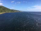
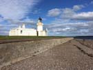 On the whole we had the route to ourselves, but that changed at Chanonry Point. Here the Moray Firth narrows between the Point and Fort George on the other side, and it's said to be the best place in the UK for spotting dolphins in the wild. We didn't see any, but we came across hundreds of binocular-wearing optimists peering out to sea.
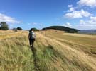
By the time we'd reached Rosemarkie we were exhausted. (Following an overnight train with a twenty-mile walk tends to do that!) However the stunning scenery and the glorious sunshine more than compensated.
Notes for future walkers:
- From the southbound bus stop on the north side of Kessock Bridge a track leads to the road end at Craigton (NH 661 482). From here an obvious sign points north-east to Kilmuir.
- We lost track of the Kilmuir path in the woods, but ultimately found our way to Croft Downie and picked our way along the shoreline from there.
- From St Mary's Church in Kilmuir (NH 676 501) we walked north-east and then, upon reaching an open field, headed diagonally north to its far corner. Immediately after leaving the field we zigzagged back left, then right to find a higher track to Taindore, whose access track led us to the road end at NH 676 513.
- From the NH 676 513 we took an obvious north-west track which after bending left and right brough us to Craighowe Mains. Staying on the track we passed through the farmyard, bent right towards Sligo, then turned right (north-west) down a track just inside the woods.
- After crossing the shallow ford at NH 665 523 we turned right (north) on a track that led to the shore. Before reaching the shore the track splits. We made the mistake of taking the left fork which resulted in the barbed wire fence/trouser encounter. The right should be fine.
- The track along the shoreline past Bayhead was reasonable, but muddy.
- Where the B9161 meets the A832 north of Munlochy a fingerpost points those looking for Avoch into a field. We couldn't find this route. Instead we followed the disused railway embankment, then cut up to the northern edge of Ord Hill. We descended the north-eastern edge of the woodland, picking up a track at NH 673 538. This track leads south-west, then curves back round to the east to pass Bay Farm and Ballone.
- From a car park at NH 687 534 we took a track into Wood Hill, and followed that around the coastal flank of the hill. Immediately upon leaving the woodland after Ormond Hill there's a path hidden in a gully back to the right, which provides access to a field that drops to meet the shore at NH 699 537.
- Between Avoch and Fortrose we walked along the pavement-less A832, but didn't find the traffic to be particularly heavy. Those wanting to avoid the road would do well to investigate the disused railway a little further inland.