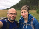
Sunday, 24 July 2016
Coastwalk
Forres → Nairn
 Distance: 17.02 miles
Ascent: 92 metres
Duration: 5 hours 23 minutes
Culbin
« Findhorn | Inverness »
Forest. Rather a lot of forest.
Perhaps 80% of this section is in the Culbin Forest, a vast expanse of trees planted between 1920 and 1960 to stabilise the dunes that had wiped out farming communities living hereabouts.
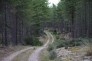 You might think that would make for a boring, unvaried walk. Far from it! Although predominantly Scots and Corsican pines, the forest hosted a wealth of other life. Mushrooms gathered in clusters along the path; ants busied themselves moving needles to and fro; silvery-green lichen provided a blanket over the sand while broom, heather and gorse added colour. At one point we spotted a roe deer nibbling at the verdant undergrowth; sadly it was too quick to be photographed.
This being Scotland in July, there were biting insects too. Judging by the two huge lumps on my temple and crown these were not your regular midge! I spotted a tick on my hand too, but managed to dislodge her before she'd driven her jaw into my skin fully.
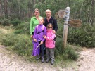 About halfway through the walk we met up with Jez, Jane, Miriam and Hannah. They previously joined us on the final coast walk in England. Hannah told me that "I walked from England to Scotland" featured in her "What I did during the holiday" writing that year.
Culbin Forest is a treasure. The Forestry Commission should be proud of what they've achieved here: a vast, well-managed estate with an poetic leaflet/map that almost demands a return visit.
Notes for future walkers:
- It seems highly likely there's a path along the western bank of the River Findhorn from Broom of Moy; we just took to the road, passing Moy House, Wellside Farm and Lake of Moy before entering the forest at NJ 018 633.
- There are myriad ways of traversing Culbin Forest, but once inside navigation can be tricky. The best way is to get the Forestry Commission map which shows numbered path junctions.
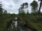 After entering the forest we walked north-east to junction 4 (NJ 023 635), north-east again to junction 3 (NJ 026 638), north to junction 5 (024 644), north-west to junction 8 (003 639), west south-west to junctions 13 (NH 996 631), 14 (NH 981 623), 15 (NH 973 621) and 18 (NH 962 616). Then south south-west to junction 19 (959 612), north-west to junction 20 (NH 955 613), west to junction 21 (NH 938 600), south-west to junction 22 (NH 922 590) and again to junction 23 (NH 920 584). From junction 23 we started south-west again, but soon headed north-west on a narrow path through the trees before picking up a path on at the very edge of the forest.
- The path between junctions 18 and 19, and the one south-west of junction 23 were badly flooded; a better route may be possible.