Saturday, 26 March 2016
Coastwalk
Findhorn → Forres
 Distance: 7.59 miles
Ascent: 42 metres
Duration: 2 hours 23 minutes
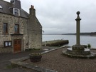
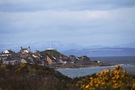
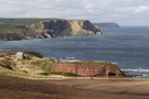
Findhorn Bay
« Lossiemouth | Nairn »
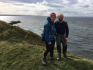
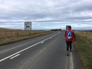
It's been a good, long week. We've walked further than we'd hoped, but still found time for a final short hop before driving home.
 I've read that it's possible to walk directly across the mud flats of Findhorn Bay but we took the less risky option: with the exception of the final mile and a half we were on roads.
There were still things to see though:
- The Findhorn Foundation, which seems to chime with many of our own views albeit with a slightly different view on spirituality. (We were surprised, however, to see Guinness on sale here amongst the craft beers in the otherwise organic whole food shop.)
- The mothballed RAF Kinloss, and a lone Nimrod aircraft parked at the end of its runway.
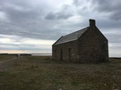
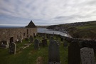
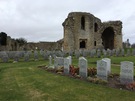 Kinloss Abbey, a place of sanctuary with a soberingly large collection of Commonwealth War Graves.
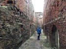
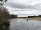 But oh, that final stretch was such a delight: a fisherman's path beside the babbling River Findhorn. It may not have been the sea, but it was such a tranquil place to end the week's walking.
Notes for future walkers:
- The Speyside Way finishes at Forres, but takes a more direct route into the town from Findhorn. At NJ 040 605 where the Way carries straight on, we turned right on the minor road through Netherton and Seafield.
- As noted above, the daring may wish to take a more direct route across the bay
- At a small car-park at NJ 026 607 you can leave the road and follow a fisherman's path all the way to the bridge across the river.
Friday, 25 March 2016
Coastwalk
Lossiemouth → Findhorn
 Distance: 18.47 miles
Ascent: 314 metres
Duration: 5 hours 52 minutes
The Furthest North
« Portgordon | Forres »
This is the furthest north I've ever been in this country. Over the week it's been a delight to look across the Moray Firth and see the indistinct shapes of the Caithness coastline become clearer. It's hard to believe that there, a little further north and a smidgen to the east, our island finally comes to a stop. But that's next year's walking.
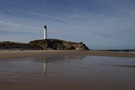
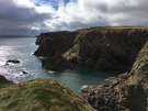
We walked on the beach from Lossie to Covesea, regaining the cliffs at the last opportunity just after rounding the lighthouse. The clear skies, the path through the fragrant gorse and the rock stacks just off the shore made the stretch past Hopeman a classic.
Somewhere hereabouts it's allegedly possible to drop down to a cave with 1,500 year-old Pictish carvings. I regret walking on by; it's another place for us to revisit.
More accessible — in fact, right beside the path at Covesea Quarry — is a collection of stones that are said to show dinosaur footprints. The explanatory board had long-since vanished so we were left squinting at the boulders, trying to work out the scale of what we were supposed to be looking at. (Dinosaurs were big, right? So we should be looking for claws the size of large dinner plates?) It felt like a case of the Emperor's New Clothes.
 Soon we were in Burghead, another delightful village with a very enthusiastic team of volunteers at the fort museum. We were the first visitors of the season and they were keen to show us everything. We promised to return in the summer. Outside the wind was dramatically chopping the sea into huge chunks which it threw at the harbour wall with force. Yes, the summer: it should be different then.
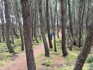
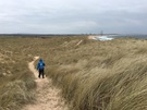
 Just like yesterday's, today's walk finished with a long stretch of forest-backed beach. But instead of walking on the beach all the way we left Burghead on the "Burma Road" path that meanders through the trees. This was a good move because once past the picnic site in the middle of the woods we wound up on the sand and by the time we reached Findhorn village we'd had quite enough of that terrain!
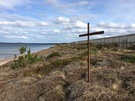 But just before dropping down off the dunes we came across a sight that arrested me. Two pieces of metal — perhaps an old fence — planted in the sand, one vertical, the other attached horizontally a third of the way down the first: a simple cross. It is Good Friday after all.
Thursday, 24 March 2016
Coastwalk
Portgordon → Lossiemouth
 Distance: 14.51 miles
Ascent: 85 metres
Duration: 4 hours 27 minutes
Independence Day
« Portsoy | Findhorn »
In an alternative present today would've been Scotland's Independence Day. Just as we were deliberately walking in Scotland on the day of the referendum so our choice of being here this week was driven by it being Alex Salmond's favoured day to break away from the Union.
Appropriately enough the first flag we saw today wasn't the Saltire but the Belgian flag. It was heart-warming to see thoughts being turned to the attacks in Brussels rather than internal politics.
In fact, the "Yes" and "No" posters that we saw in large quantities a year after the vote have largely gone now. I'd like to think the matter was settled, but there's an undercurrent of change, as if independence is inevitable but the date undecided. As one house in Portgordon proclaimed, "We're still Yes". Change takes time, no matter how dedicated the protagonists.
 We're firmly on the Speyside Way now so route finding is easy (just follow the Thistles — equivalent to the Acorns used on the English and Welsh National Trails).
In Garmouth a stone commemorates the signing of the Solemn League and Covenant by King Charles II in 1650. According to Britannica the signatories pledged to work for a civil and religious union of England, Scotland and Ireland". I was surprised to not find a "We're still No" sticker adorning it.
The wildlife of the area continues to diversify in front of our eyes. Today's new spot was a hare (and a dog darting after it!). We also passed the Scottish Dolphin Centre; hopefully it'll be open when we're back this way in the summer.
 Summer seems so far away though. As we crossed the River Spey we could see snow capping the summit of Ben Rinnes away to the south.
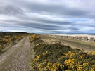
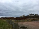
 The walk finished with a long beach walk along from Kingston to Lossiemouth, a beach backed by the forest of Innes Links and separated from the trees by thousands of World War Two-era "dragons teeth" and gun emplacements hidden carefully amongst the dunes. Did those who constructed them expect them to still be standing 75 years later? What would the framers of the Covenant have made of the state of the Union 375 years after their work?
Wednesday, 23 March 2016
Coastwalk
Portsoy → Portgordon
 Distance: 17.79 miles
Ascent: 382 metres
Duration: 5 hours 58 minutes
Six harbours and one cave
« Gardenstown | Lossiemouth »
The Moray Coast Trail is a 45-mile path from Cullen to Forres. We'll be following it for the rest of the week, which should make route-finding significantly easier (and eliminate almost all road walking). Presumably Cullen was chosen as the starting point due to its proximity to the boundary of Moray, which is a shame since there's a path of equal quality all the way back to Portsoy.
An annual charity walk begins in Portsoy and takes in six harbours: Portsoy, Sandend, Cullen, Portknockie, Findochty and Buckie. Our walk today added one more in Portgordon.
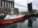
First things first: we loved Portsoy. Driving through on the A98 you see just a snatch of the village: a couple of shops (including a fantastic baker) but not much else. You need to venture north towards the harbour to find the real action. The oldest harbour on the Moray Firth, Portsoy is reminiscent of the Fife fishing villages, with a few hints of Cornwall thrown in.
Next up is Sandend. The path climbs up behind the houses halfway along the village street, but before taking it pop in to "Messrs. J. Smith Fishmerchant". It's primarily a wholesaler with a small packing unit here on the village street, but they'll happily sell to passing walkers. Just before the village is the recently reopened Glen Glassaugh distillery. It's always a joy to see distilleries coming back online, but their whisky wasn't particularly to our liking.
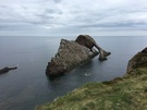 Portknockie and Findochty were equally charming and their settings spectacular. At Portknockie, Bow Fiddle Rock is an obligatory photo-opportunity although to us it looked more like a whale breaching the surface of the water than a violin. In Findochty a mural sets out scenes from local history and we were delighted to see in one corner the question "Fit like?" ("Aye, fine.")
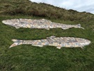 It's been another good day for animals: deer in the fields, the obigatory doocot, a weasel on the rocks in Portessie, seals galore just outside Portgordon and even a starfish on the beach.
We saw a dog too. A mysterious dog.
He appeared on the path a fair distance ahead of us somewhere between Findlater Castle and Logie Head. Every few metres he'd disappear, only to pop up again a little further on. He didn't seem to be with anyone but we could see him peering at from gaps in the rocks, like some sort of friendly spirit.
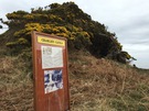 It was round about here that we found Charlie's Cave. Charlie Marioni deserted the French army and lived as a hermit on the beach at Sunnyside in the 1920s, sheltered from the weather by a shallow hollow in the cliff and a driftwood roof. A sign by the cave tells the sorry tale of a man who was happy with his self-sufficient bartering lifestyle (perhaps supplemented with a little scrumping?) but was eventually brought before the courts after a local land tenant lodged a formal complaint about him. Fined as an unregistered alien, he quietly dispatched his two cat companions then turned his back on his home of 13 years and eventually died in poverty in England. A notice on the beach (described in a council meeting last year as "inappropriate") sets out the whole heartbreaking tale.
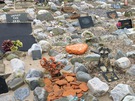 (On the outskirts of Cullen the path passes by a huge gaudy pet cemetery. That broke the spell.)
 This is a walk was excellent: whisky, fish, wildlife, fascinating geology and a shaggy dog story. We highly recommend it.
Tuesday, 22 March 2016
Coastwalk
Gardenstown → Portsoy
 Distance: 18.39 miles
Ascent: 426 metres
Duration: 5 hours 43 minutes
Seatown
« Fraserburgh | Portgordon »
Today's been another long day of road walking, but hopefully it'll be the last such day this week. In fact, it was nearly entirely roads with only the first couple of miles out of Gamrie offering anything like enjoyable walking.
 Most of the coastal settlements along this stretch of coast are made up of multiple distinct communities. In almost every case there will be a cluster of houses packed right up against the beach called Seatown. The architecture is distinctive: low one-and-a-half storey stone houses, gable-ends presented to the sea, seemingly constructed in a slightly haphazard arrangement on whatever land was available.
Harbour Road in Gamrie leads to Seatown, and it'd be another nerve-racking drive for those foolish enough to try it, just like in Crovie. Eventually the road ends at a car park and the path drops to the delightful beach, at the far end of which a path leads up to the old kirk.
Gardenstown has at least half a dozen churches but St John's Kirk was the first. On a section of the harbour wall is the painted declaration "God is love".
The path up the hill had suffered in the storms earlier this year, and coupled with the overcast windy weather and the experience of walking through Seatown it's easy to see how much faith was a comfort to those living here.
 Past the kirk we were on roads to Macduff, but thankfully mostly with good visibility. A cycle track between Banff and Whitehills provided a little relief. Downies of Whitehills has a fresh fish counter but we passed by without purchase.
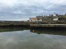
 Then onto the roads again — albeit quiet local ones this time — before the final descent into Portsoy. The harbour at Portsoy looks charming but we didn't explore much; we were keen to get back to the cottage and besides, we'll be here again tomorrow.
Notes for future walkers:
- Follow the beach west out of Gamrie, then pick up a path up to the churchyard that leaves the beach at Kirk Burn.
- We walked to Macduff along the B9031 (with a small diversion onto a local road past Mains of Melrose for a breather), then the A98. It is almost certainly possible to find a better route through the fields starting above the church. From Banff an excellent cycle track leads to Whitehills.
- You can regain the prom (High Shore) from the A98 (Buchan Road) by tucking down an alley behind the Royal Tarlair Golf Club just before the first house in Macduff.
- From Whitehills we took the minor road west out of the village to NJ 644 646, then the B9139 to NJ 597 657, at which point we took the track north north-east to the cross tracks at NJ 598 660 where we turned left down a steep track signed to Back Bay. While this took us off the roads, it was very wet and not a great idea.
Monday, 21 March 2016
Coastwalk
Fraserburgh → Gardenstown
 Distance: 19.41 miles
Ascent: 688 metres
Duration: 6 hours 12 minutes
A Scottish safari
« Peterhead | Portsoy »
After yesterday we really didn't need another long walk today, but since we're staying in Gamrie this week it made sense to walk back to the cottage rather than cut short elsewhere. Most of the walk was on roads, which made the going easier.
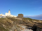 Had we been visiting in the tourist season I think we'd have spent longer in Fraserburgh. The Museum of Scottish Lighthouses looked fascinating. It's in buildings adjoining a lighthouse built on top of an old castle. On the shore beneath the old foghorns is Wine Tower, said to be haunted by the ghost of a girl who threw herself from the roof of the tower after her lover was chained in a cave beneath the structure until he drowned. Legend has it that you can see her blood on the rocks, but it looked suspiciously like surplus paint from the foghorns to me. (Maybe this is how legends begin.)
The central part of the walk was a mini-safari. At Phingask Shore we saw more seals, then at Braco Park deer leapt out of our way into an orchard. A little further on Stonebriggs Farm played host to a peacock and peahens.
West of Rosehearty the landscape changed, the long sandy beaches replaced by high cliffs of folded rock. Given the distance to cover we elected to use the local roads and farm tracks rather than seek a more coastal path.
 Tucked into one of the folds is Pennan (emphasis on the first syllable), famous as the location for the 1983 film Local Hero, a tale of a brash American businessman intent on bulldozing the village for personal profit. When Trump started ripping apart the Meinie Links to build another monument to his ego, comparisons with the film were inevitable but sadly thus far the ending is not the same.
The Inn itself was closed so we didn't end up looking like complete cinematic tourist/pilgrims, eating lunch on the harbour wall instead.
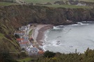
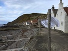
West of Pennan is an even smaller village. The houses in Crovie (pronounced "Crivvie") huddle next to each other between the cliff foot and the sea, leaving just enough space in front for a narrow sea wall bedecked with washing lines.
 Beyond Crovie, Gamrie. Formally known as Gardenstown it the village is named after its 1720 founder, Alexander Garden. But everyone here eschews that name for the name of the bay on which it sits. I like to think it's a quiet protest against baronial power.
In 2007 Gamrie was the setting for a Channel 4 reality-TV series "The Baron of Troup" that seems to have been set up with the very worst of intentions. The fact that I can't find out much about the series suggests it got the reception it deserved.
Notes for future walkers:
- From Rosehearty we took the B9031 to the cross-roads at NJ 922 657 where we turned west on the narrow local road past Stonebriggs.
- At Mill Farm (NJ 884 642) there's a signpost pointing out the route to Pennan by taking the farm track across The Dour, then up past Bankhead. The track bends right towards Clinterty at NJ 875 643 but we continued west on an enclosed path.
- Just shy of the B9031 at NJ 857 642 we turned north following signposts along a farm track to the derelict Pennan Farm.
- At the farm, go west and downhill, eventually into a small valley that leads into Pennan. (It was a bit soggy here.)
- Although we'd read that it's possible to walk around the cliffs of Troup Head between Pennan and Crovie, we returned to the roads: first the B9031, then local roads through Middleton (NJ 822 648), Protston (NJ 818 648) and Greenley to NJ 821 657. Here we turned down a farm track past Crovie Farm before dropping into the village.
- Between Crovie and Gardenstown there's an obvious path at the back of the beach, but it might be submerged on some tides.
Sunday, 20 March 2016
Coastwalk
Peterhead → Fraserburgh
 Distance: 21.31 miles
Ascent: 386 metres
Duration: 6 hours 40 minutes
Turning the corner
« Cruden Bay | Gardenstown »
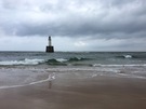
Looking at a small-scale map of Scotland, you would think it would be obvious when you've reached the north-east corner of Aberdeenshire — the point when you stop heading north, turn the corner, and start heading west. Not so. Without a doubt it lies somewhere between Peterhead and Fraserburgh but the coastline here is a long, rounded, sandy beach. About halfway between the towns there's a lighthouse at Rattray Head: we'll declare it to be the corner.
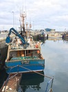
 Peterhead and Fraserburgh feel as if they need to turn a corner themselves. Although both are working ports with active industry, much of the industry is dependent on oil and the recent suppression of oil prices have had a devastating impact. The remains of the fishing industry is in decline too, with Fraserburgh's packing factories in the balance.
There are hints of the old way of life though, for example what's reputed to be Scotland's oldest salmon smokehouse near the footbridge across the River Ugie. There's also the dialect, and the memories of local people.
 At St Combs (pronounced like the hairstyling tool) we fell into conversation with a dog-walker, who told us about how the area used to be when her 'forefolk' worked the shore. Her accent was rich ("Did you come through the water?" she asked, rhyming the last word with batter) and her speech full of local Doric Scots idiom, but her warmth and expressive delivery helped to patch the holes in our understanding. When we asked how to pronounce the village name she told us that "many of the English want to put an 'oo' in"; when we mentioned that we were staying at Gardenstown this week, her eyes twinkled: "Aye, Gamrie", she nodded, referring too the village's original name.
Later the young supermarket checkout assistant in Fraserburgh greeted us with the question "Fit like?" (how are you?). It's not just the old who use Doric; the correct response would probably have been "aye, fine; yerrsel?" but instead I presented a look of bemusement. It'll take a while to tune into these colloquialisms.
Notes for future walkers:
- This is a huge walk, almost entirely on a sandy beach, with few opportunities to curtail.
- We crossed the Annachie Burn on the bridge at the southern extent of the gas terminal at NK 105 531.
 There's a reasonable path just outside the gas terminal fence, used by security patrols and their alsatians!
- We crossed the outfall of Loch of Strathbeg on the bridge at NK 066 604. This is the "water" our friend asked us about, implying that it's fordable on the beach.
- From Inverallochy we followed the B9107 inland to the B9033, then took to Fraserburgh Golf Course once we'd crossed the Water of Philorth.
Saturday, 19 March 2016
Coastwalk
Cruden Bay → Peterhead
 Distance: 12.14 miles
Ascent: 315 metres
Duration: 3 hours 56 minutes
Old and new
« Newburgh | Fraserburgh »
Almost exactly six months since we walked into Cruden Bay, we're back to pick up where we left off. When we were last in the area we decided that Stonehaven would be well worth another visit, and on our overnight stay here we also took in the delights of the Carron Fish Bar's infamous deep fried Mars Bar: a glistening, beige log of tooth-aching sweetness. On the "so wrong it's right" spectrum, it's heavily on the side of wrong. Culinary disappointments aside, we so much enjoyed our stay at the recently-opened Arduthie House B&B that we've booked to stay again on our way back.
The route out of Cruden Bay quickly arrives at New Slains Castle, a Gothic hybrid of Jacobean and more recent stonework, which forms a brooding and impressive sight on the cliff edge. The mixture of ages in the building is striking, but this is a relatively recent ruin - the roof was removed in the 1920s so that the owner could avoid paying tax. Looking through the eyeless windows and empty halls, it feels as if the empty shell is waiting for its next regeneration.
 The path becomes narrow and twisting from this point, and runs very close to the cliff edge. Cliff erosion is evident at the Bullers of Buchan, a group of magnificent rock arches, stacks and sea caves, which have been carved out of the sandstone by the battering of waves and wind. In contrast to our previous visit to the area during the early autumn, the many crevices and wind-worn shelves on the Bullers were filled with nesting fulmars, kittiwakes and gulls, which form large and noisy colonies along the coast. The rocky nature of this section also makes it a good spot for watching seals: we spotted a small group in a sea cave at Yoag's Haven.
 In addition to being narrow, the path is also indistinct in several places along this section, particularly between Peterhead's power station and prison. There's a sense of contrast here, too: slightly apart from the new prison building — which looks like a slightly utilitarian motel — the older disused prison building stands tall and forbidding behind a high stone wall, a grim reminder of a harsher time. It was something of a relief to arrive at the edge of the town, where the path follows a route along the edge of the harbour.
 For us, Peterhead holds another point of interest: it's the most easterly point on Scotland's mainland. Sadly there seems to be nothing to celebrate this, just a raised swing bridge across to the dock buildings on Keith Inch. Then again, we didn't find anything at Lizard Point marking that out as the southernmost point of England either.
Notes for future walkers:
- The obvious route into Boddam is along the line of a disused railway. However, we found this to be waterlogged in the cuttings, and staying high on the seaward side was difficult underfoot. Eventually we gave up and walked along the A90.
- At Sandford Bay, north of Peterhead Power Station, take the path up the cliff before the water outlet; the low-level path is washed away part-way round the bay. (Besides, the overgrown walled garden of Sandford Lodge is fascinating.)
- When the road past the modern prison ends beside the South Breakwater in Peterhead, climb the cliff and walk alongside the prison boundary — the fence around the harbour makes a lower route difficult.
- The lifting bridge onto Keith Inch appears to be permanently up, so don't expect to walk round that island.
Friday, 11 March 2016
Film
Hail, Caesar!
The Coen brothers; George Clooney, Ralph Finnes, Scarlett Johansson, Tilda Swinton, Frances McDormand; rave reviews; 1950s Hollywood with a subversive subplot. Despite all the ingredients for a great film, Hail, Caesar! instead felt like a self-indulgent cobbling together of luvvies' set-pieces and that I wasn't cool enough to enjoy it.
(Emma, on the other hand, thought it was great.)