Monday, 21 March 2016
Coastwalk
Fraserburgh → Gardenstown
 Distance: 19.41 miles
Ascent: 688 metres
Duration: 6 hours 12 minutes
A Scottish safari
« Peterhead | Portsoy »
After yesterday we really didn't need another long walk today, but since we're staying in Gamrie this week it made sense to walk back to the cottage rather than cut short elsewhere. Most of the walk was on roads, which made the going easier.
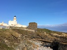 Had we been visiting in the tourist season I think we'd have spent longer in Fraserburgh. The Museum of Scottish Lighthouses looked fascinating. It's in buildings adjoining a lighthouse built on top of an old castle. On the shore beneath the old foghorns is Wine Tower, said to be haunted by the ghost of a girl who threw herself from the roof of the tower after her lover was chained in a cave beneath the structure until he drowned. Legend has it that you can see her blood on the rocks, but it looked suspiciously like surplus paint from the foghorns to me. (Maybe this is how legends begin.)
The central part of the walk was a mini-safari. At Phingask Shore we saw more seals, then at Braco Park deer leapt out of our way into an orchard. A little further on Stonebriggs Farm played host to a peacock and peahens.
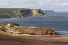
West of Rosehearty the landscape changed, the long sandy beaches replaced by high cliffs of folded rock. Given the distance to cover we elected to use the local roads and farm tracks rather than seek a more coastal path.
 Tucked into one of the folds is Pennan (emphasis on the first syllable), famous as the location for the 1983 film Local Hero, a tale of a brash American businessman intent on bulldozing the village for personal profit. When Trump started ripping apart the Meinie Links to build another monument to his ego, comparisons with the film were inevitable but sadly thus far the ending is not the same.
The Inn itself was closed so we didn't end up looking like complete cinematic tourist/pilgrims, eating lunch on the harbour wall instead.
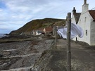
West of Pennan is an even smaller village. The houses in Crovie (pronounced "Crivvie") huddle next to each other between the cliff foot and the sea, leaving just enough space in front for a narrow sea wall bedecked with washing lines.
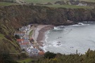
 Beyond Crovie, Gamrie. Formally known as Gardenstown it the village is named after its 1720 founder, Alexander Garden. But everyone here eschews that name for the name of the bay on which it sits. I like to think it's a quiet protest against baronial power.
In 2007 Gamrie was the setting for a Channel 4 reality-TV series "The Baron of Troup" that seems to have been set up with the very worst of intentions. The fact that I can't find out much about the series suggests it got the reception it deserved.
Notes for future walkers:
- From Rosehearty we took the B9031 to the cross-roads at NJ 922 657 where we turned west on the narrow local road past Stonebriggs.
- At Mill Farm (NJ 884 642) there's a signpost pointing out the route to Pennan by taking the farm track across The Dour, then up past Bankhead. The track bends right towards Clinterty at NJ 875 643 but we continued west on an enclosed path.
- Just shy of the B9031 at NJ 857 642 we turned north following signposts along a farm track to the derelict Pennan Farm.
- At the farm, go west and downhill, eventually into a small valley that leads into Pennan. (It was a bit soggy here.)
- Although we'd read that it's possible to walk around the cliffs of Troup Head between Pennan and Crovie, we returned to the roads: first the B9031, then local roads through Middleton (NJ 822 648), Protston (NJ 818 648) and Greenley to NJ 821 657. Here we turned down a farm track past Crovie Farm before dropping into the village.
- Between Crovie and Gardenstown there's an obvious path at the back of the beach, but it might be submerged on some tides.