Saturday, 1 September 2012
Coastwalk , South West Coast Path
Portreath → Hayle
 Distance: 11.7 miles
Ascent: 417 metres
Duration: 4 hours 8 minutes
Collapse
« Perranporth | Lelant Saltings »
The awful weather this summer has meant that we're behind schedule with the plan to complete the South West Coast Path before the year end. So it's time for another insanely long train journey for just a couple of short walks.
This walk is very much in two parts: along the cliff-tops, then across the beach.
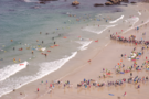
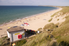
Portreath beach was busy with what looked like a lifesaving or surfing contest, rows of competitors splashing into the waves at regular intervals.
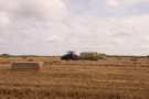 After climbing out of Portreath then crossing one deep valley, the path was more-or-less easy going. Just inland from the cliff-edge, a farmer was converting a recently harvested wheat field into neat rows of bales. The summer is most definitely over.
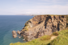 Two thirds of the way along the cliff-top section is Hell's Mouth. Almost exactly a year ago there was a massive collapse of the cliff here, caught on camera by a council official who had recently rolled the path inland as a precaution. The scar is still very visible, a lighter coloured rock and scree slope that's not yet been covered by the grass that it will inevitably succumb to.
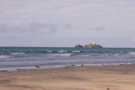 Before too long we reached Godrevey Point, with its offshore lighthouse and tourists pointing binoculars down to the seal pups sheltering in deserted coves. Earlier in the year this headland participated in Peace Camp, an installation of poetry and tents as part of the London 2012 festival.
 South of the headland Gwithian beach stretched before us; the remainder of the walk being along its fine sands before being abruptly dropped onto the brownfield fringes of Hayle.
Both halves of the walk were enjoyable, but I'm certain that the cliff-tops will remain with me longer than the beach.