Sunday, 30 September 2012
Coastwalk , South West Coast Path
Land's End → Mousehole
 Distance: 13.1 miles
Ascent: 1081 metres
Duration: 5 hours 46 minutes
The set-up
« Pendeen | Penzance »
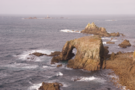
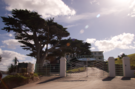
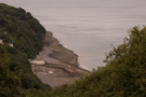
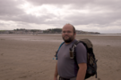
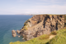
And so to Cornwall for the final gap of the week! When I started to plan completing the South West Coast Path, the big question was which walk to do last. The answer was obvious once I'd found it: we had to finish at Land's End at the very tip of the peninsula. Today's walk sets up the grand finalé; for a couple of days' time.
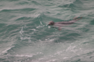
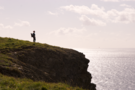
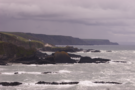
The first half of the walk was one of the best walks we've ever done. The path was easy (and very popular); the views were stunning. Just before reaching the wonderful cove called Nanjizal we looked down to see seals swimming around the wreck of the City of Cardiff which has laid on the seabed here for a hundred years.
Before too long we reached the car park of the Minack Theatre, an open-air theatre set on the clifftop above Porthcurno. We'd visited it on our honeymoon and I was looking forward to seeing it from a different perspective - the path. Unfortunately, the carefully-landscaped grounds reserved the views for paying visitors, not passing walkers.
Porthcurno village itself is set a short distance back from the beach, so we didn't see any of its delights. This is a shame since I'd really enjoyed visiting the village six years ago, seeing the theatre and the unique Telegraph Museum cut into the cliffs above the beach where the transatlantic cables were once landed.
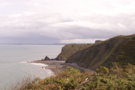
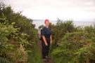
East of Porthcurno the path seemed to be much less popular - presumably due to the distance from Land's End. It became harder work too, with ascents and descents increasing in frequency although the effort was rewarded with stunning hamlets such as Penberth and a curiously isolated house at Boskenna Cliff.
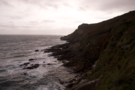
Either side of Lamorna Cove the going got even tougher as the path surface was interrupted by one bolder after another. It was tiring going, so I was delighted when we finally reached the houses on the outskirts of Mousehole.
It has been a tiring day. This doesn't bode well for tomorrow's walk which I expect to be harder still.
Saturday, 29 September 2012
Places
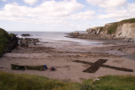
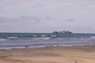
Burgh Island
Like Clovelly, Burgh Island is best seen in your imagination. Think about all the things you've read about the island: the sands that link it to the mainland at low tide, the sea-tractor that maintains the link at high tide; the exclusive 1930s-themed hotel, inspiration for Agatha Christie's And Then There Were None.
The magic of all these things will be severely tarnished should you ever visit the island.
 We took a short circuit of the accessible footpaths at the end of today's coastwalk, and almost immediately regretted it. There are copious signs telling visitors to "keep to the west side of the island only", and reminding mere mortals that their presence was endured by the owners, rather than enjoyed. The hotel was very definitely off-limits for mere mortals.
Our top recommendation: instead of visiting the island, book a window-table at the Bay View Cafe/Bistro and watch the sun set and the tide wax and wane while enjoying a delicious meal. Dream of Burgh Island (or Soldier Island, as is appears in modern versions of Christie's book). Just don't ever visit it.
Coastwalk , South West Coast Path
Wonwell → Bigbury-on-Sea
 Distance: 4.62 miles
Ascent: 318 metres
Duration: 1 hour 58 minutes
And then there was one
« Wembury | Salcombe »
After finishing the north Devon Coast yesterday we drove right across the county to Bigbury on the south coast.
 Back in August we'd intended to walk as far as Bigbury when we crossed the River Erme, but tiredness and timing got the better of us. (Besides, wading across the river was a spectacular climax to that day.) So this morning we were back at the river, looking down at the old ford. I was seriously tempted to kick my boots off and plunge into the water again.
 The walk to Bigbury was easier than expected, despite a number of significant ascents. As we descended into Ayrmer Cove we started to notice canvas shelters dotted round the dunes and a large "X" made out of seaweed on the back of the beach. This was a group of men (yes, all men) on a coastal survival course. They seemed to be having a great time, but their camp looked very scraggy.
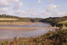
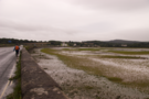
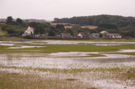
![]() Finally we reached Bigbury where the low tide meant that Burgh Island was joined to the shore by a strand of sand.
Finally we reached Bigbury where the low tide meant that Burgh Island was joined to the shore by a strand of sand.
Another day, another gap plugged, another National Trail Guide finished, a county completed. Thanks Devon, you've been beautiful. Just one gap left on the SWCP now.
Note: we stayed overnight in the Summer Winds B&B at Bigbury-on-Sea, which was excellent - it's run by very friendly people, and the breakfast was brilliant. If you're there, also look out for the Bay Cafe just along the road.
Friday, 28 September 2012
Coastwalk , South West Coast Path
Clovelly → Hartland Quay
 Distance: 10.3 miles
Ascent: 677 metres
Duration: 4 hours 18 minutes
Landmarks
« Westward Ho! | Morwenstow »
The down-side to walking the coast in parts and out-of-order is that you can get left with little gaps to plug. The remainder of this year's walking will be gap plugging, starting this week with three remaining sections of the South West Coast Path. With any luck, by Tuesday we will have completed this, Britain's longest National Trail.
Each day we'll also have a milestone to celebrate. Little moments like finishing a map or a county are the landmarks that demonstrate we're making progress on the walk, pointing us in the direction of a complete circuit of our island.
 The weather has been awful over the past few days, with high rainfall causing flooding right across the country. Consequently we were prepared for the worst, but surprisingly walked the entire day without being rained on. The only evidence of the poor weather was the stream at Mouthmill Cove which was swollen, hiding the promised stepping stones. It wasn't too difficult to get to the other side though, with a little splashing between hopping from boulder to boulder.
The guide books suggest that from Clovelly to Hartland Point there was little ascent or descent. That's not quite true: Mouthmill Cove and Windbury Head near the start of the walk challenged the calves early on.
 At Hartland Point the character of the walk changed. From walking to the west, we turned south and faced a much more dramatic landscape: one of rocky ridges pointing out into the Atlantic, rather than the rolling cliffs that faced the Bristol Channel. About the only thing the two sections had in common was the fine view of Lundy (which was absolutely clear, in contrast to the mist that obscured the island when we were here earlier in the year).
Despite the rugged nature of this latter part of the walk, it was no more strenuous than the earlier section and we soon reached the tiny cluster of buildings at Hartland Quay where we celebrated completing the north Devon coast, and the second of the four National Trail Guides to the SWCP.
Unfortunately the lack of public transport on the coast here meant that although our coast walking was over for the day, we still had two and a half miles to walk back to the car in Hartland village itself.
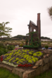
 And we were grateful even for this coda since it took us through the village of Stoke, where St Nectan's Church dominates the landscape for miles around with its landmark tower. The interior is worth a visit too, featuring a beautiful painted vaulted ceiling and huge, intricate rood screen.
Saturday, 22 September 2012
Angels
The Angel's Share
Another Friday evening at Fred's. It's great to have neighbours that make good company.
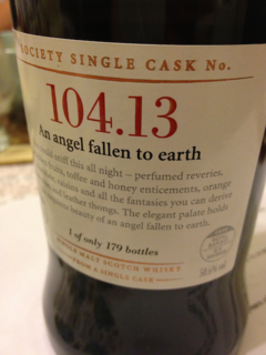
Amongst the selection on offer tonight was a 36 year-old Glen Craig titled An Angel Fallen to Earth. Personally I don't share the enthusiasm of the Sottish Malt Whisky Society for this one.
Monday, 17 September 2012
Sunday, 16 September 2012
Coastwalk , South West Coast Path
Westward Ho! → Clovelly
 Distance: 11.6 miles
Ascent: 737 metres
Duration: 4 hours 40 minutes
Phesants
« Barnstaple | Hartland Quay »
Late start yesterday; early start today. We were determined to walk as far as Clovelly, and still catch the 1523 train home from Barnstaple so throughout the walk the clock was ticking.
The B&B we stayed in was kind enough to oblige us with an early breakfast and we were on the path at eight. Early morning starts are fast becoming a firm favourite; with dew still on the ground, dog walkers and joggers the only others on the path, this is a special time. All the more so when we stumble across the tent of a wild camper who's not yet dared greet the day.
 Immediately south of Westward Ho! the path is glorious. Initially along an old railway line, it soon switches to a wide grassy track rolling over the low cliffs. After four miles its character changes as the height of the cliffs rises, along with the energy required to summit them. During this middle third of the walk our average speed plummeted and we began to wonder whether we'd be in time for our taxi.
The village of Bucks Mills - seven miles into the walk - looked well worth exploring, sharing as it does many of Clovelly's characteristics but without the negative side of being a tourist hot spot. Mindful of time, we didn't linger and headed on for the final push.
This last third turned out to be very easy - once we had regained the height we had suddenly lost by dropping to Bucks Mills. The final two miles were along the Hobby Drive, a carriage ride constructed on instruction of the owner of the Clovelly estate. Our guide book explains that such grand projects were commonplace as a means of providing employment during a time of depression. It's not clear what the equivalent would be today.
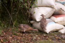 Most noticeable along the drive were the pheasants. We're used to seeing one or two on our walks, but here they were in their hundreds, maybe even thousands. At one point we had perhaps forty birds scampering along the drive ahead of us, trying to get out of our way, but failing to recognise that we too might be continuing in the same direction.
Discarded grain sacks and feeders confirmed that this was a rearing operation, presumably so that the birds could be shot for sport later in the year. There may not be labourers extending the Hobby Drive this year, but some things never change - Clovelly is still run by one family.
On that note, we spent a day visiting the village earlier in the year and were sorely disappointed. Clovelly is a beautiful village that seems to have been transformed into a money-making machine. By all means visit it, but be prepared for a lacklustre visitors' centre and shops full of tat. Be prepared also to pay for the privilege, although we'd recommend avoiding the paid-for visitors' centre and walking along the public rights of way into the village for free.
Saturday, 15 September 2012
Coastwalk , South West Coast Path
Barnstaple → Westward Ho!
 Distance: 12.3 miles
Ascent: 88 metres
Duration: 4 hours 8 minutes
Exclamation!
« Saunton | Clovelly »
Some places carry a certain mystique. Some walks are unique, and are anticipated for a long time. Today these two things come together with my love of cartographic trivia: Westward Ho! - the terminus of today's walk - is the only place in the country whose name includes a punctuation mark. How could I not be looking forward to it?
 The walk itself was rather tedious. Between Barnstaple and Instow, the coast path follows a cycle route along the track-bed of a dismantled railway. Earlier in the day the Tour of Britain cycle race had commenced in Barnstaple, encouraging half the town into the saddle. Every few hundred metres we'd hear a bell behind us, or see a wobbly toddler riding out for the first time ahead. What should've been a straightforward section was a stressful gauntlet run.
Towards Instow an alternative, more coastal path diverged from the wannabe-Wigginses, and normal tranquil service was resumed.
 A seasonal ferry runs across the River Torridge from Instow to Appledore two hours either side of high tide. We'd timed our walk to coincide, resulting in a leisurely start this morning, and a somewhat late finish in the evening. The ferry service was resumed by a local community group last year after a gap of many years. I sincerely hope they'll be able to keep it running since it was utterly charming, and lent these North Devon villages a flavour of the South Cornwall twin villages such as Fowey and Polruan.
After landing, and a circuit of England's oldest golf course at Northam Burrows, we finally reached Westward Ho!.
 If the village's name intrigues you, and fills you with a sense of inquisitive wonder, then I beg you read no more. Let it forever live that way in your imagination. For Westward Ho! is a confused village. Half of it looks run-down and tacky; the other half has been rebuilt on the dream that this can once again become a bustling seaside resort. I hope it succeeds, but at the moment the jury's out.
Optimistically I would note that the first two places we tried to get a meal this evening were fully booked. On the other had, the pub we ended up in, while charming, was tired and in need of a jolt.
I hope that should we ever return to Westward Ho!, the optimists will have won.
Friday, 14 September 2012
Album
Reject
Three Solas-associated acts are releasing new albums this autumn. First out of the blocks are Stanley Odd, with their second album Reject. Through three EPs last year we'd come to be huge fans of this Edinburgh-based hip-hop outfit.
If you want to catch up with their back catalogue, check out The Day I Went Deaf, or its cheeky unauthorised Jackson Five mashup.

Reject is more of the same: huge sound, intelligent and provoking rap merged with smoky backing vocals, all delivered with wit, Scots idiom and authentic accents.
Sounds odd? That's a complement. "You say 'reject', I say individual" raps Solareye on Will the Last One Out Please Turn Off the Light. The band always make me think of Drummond/Cauty's pre-KLF outfit, The JAMs.
There's some material here that will become dated due to its subject matter (I doubt Nick Clegg and Andrew Landsley have been named on many other tracks). Others could become useful historic accounts such as Marriage Counselling, which lays out the independence debate as an exchange of letters between Caledonia and Britannia.
Sadly nothing here quite surpasses my favourite Odd track, the narrative How to Sing the Blues Laughing from one of last year's EPs.
But that shouldn't take away from what is here. Tracks about twenty-first century life while steering clear of hip-hop stereotypes are uplifting. Slightly reminiscent of a line in U2's Unknown Caller, the track Going Through the Motions plays out with the vocal "It's a beautiful day / please restart me / make my heart beat".
This deserves much wider distribution.
Sunday, 2 September 2012
Coastwalk , South West Coast Path
Hayle → Lelant Saltings
 Distance: 1.79 miles
Ascent: 4 metres
Duration: 36 minutes
Estuary
« Portreath | St Ives »
 This was always going to be one of the shortest walks we'd do, and with the early rain this was probably just as well. We'd not spent much time in Hayle when we were here six years ago - the gap in this part of the walk has remained unfilled since then - so it was interesting to notice that despite the town's outwardly shabby appearance, there was a row of proudly independent shops, colourful flower beds and several B&Bs. Although Hayle doesn't feel prosperous, it's an optimistic sign that the town is trying to resist the recession.
 The river Hayle estuary is broad and tidal; bird watchers were braving the rain to spot late summer wading birds as we approached the turning to Lelant Saltings station. New houses have been built since we were last here, but the unfinished-looking car park was as we remembered it. Since we had time, we walked on to St Erth station to catch the mainline train to Reading, but it would have been satisfying to have had a last look back up the coast towards Portreath again.
Saturday, 1 September 2012
Coastwalk , South West Coast Path
Portreath → Hayle
 Distance: 11.7 miles
Ascent: 417 metres
Duration: 4 hours 8 minutes
Collapse
« Perranporth | Lelant Saltings »
The awful weather this summer has meant that we're behind schedule with the plan to complete the South West Coast Path before the year end. So it's time for another insanely long train journey for just a couple of short walks.
This walk is very much in two parts: along the cliff-tops, then across the beach.
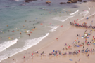
Portreath beach was busy with what looked like a lifesaving or surfing contest, rows of competitors splashing into the waves at regular intervals.
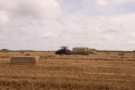 After climbing out of Portreath then crossing one deep valley, the path was more-or-less easy going. Just inland from the cliff-edge, a farmer was converting a recently harvested wheat field into neat rows of bales. The summer is most definitely over.
 Two thirds of the way along the cliff-top section is Hell's Mouth. Almost exactly a year ago there was a massive collapse of the cliff here, caught on camera by a council official who had recently rolled the path inland as a precaution. The scar is still very visible, a lighter coloured rock and scree slope that's not yet been covered by the grass that it will inevitably succumb to.
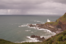
 Before too long we reached Godrevey Point, with its offshore lighthouse and tourists pointing binoculars down to the seal pups sheltering in deserted coves. Earlier in the year this headland participated in Peace Camp, an installation of poetry and tents as part of the London 2012 festival.
 South of the headland Gwithian beach stretched before us; the remainder of the walk being along its fine sands before being abruptly dropped onto the brownfield fringes of Hayle.
Both halves of the walk were enjoyable, but I'm certain that the cliff-tops will remain with me longer than the beach.