Friday, 30 October 2009
Coastwalk , South West Coast Path
Mousehole → Penzance
 Distance: 3.75 miles
Ascent: 50 metres
Duration: 1 hour 25 minutes
At sea level
« Land's End | Porthleven »
The Saturday before we got married, Emma and I visited Greenwich. It's somewhere I've been many times before but a new place for Em. There on top of the hill in the park stands the Royal Observatory and outside a brass line marks the Meridian - the line of zero latitude.
A further twelve years back I stood with my family at another line: on the equator - the line of zero longitude - on our last holiday together. A sign by the roadside proudly declared the location while locals offered demonstrations of the clockwise/anticlockwise plughole myth.
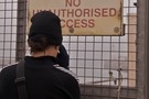
With two dimensions covered off I was looking forward to seeing how the line of zero altitude was celebrated at its point of definitive measurement on our island: the Tidal Observatory on the South Pier at Newlyn Harbour.
I was disappointed.
There was nothing: no public access to the pier, no footnote on the town signs, not even a plaque that could be seen by the public.

The closest we got was the landward end of the pier where - hidden by the side of a track - Ordnance Survey Benchmark Faceplate 1502 serves the purpose of being an auxiliary benchmark to the tidal gauge.
The remainder of the short walk was uneventful, with a little drizzle. It matched my mood perfectly.