Sunday, 1 January 2012
Coastwalk
The Plan
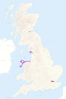 Last year was my best ever year for coastwalking. The map on the right shows 2011's walks in purple.
We walked more "new" miles along the coast than in any other year; at 435 miles, the total for 2011 was actually greater than the combined totals for 2007-2010 and pushed over 400 miles for the first time. We also managed to complete a coast walk each calendar month, something I've been wanting to do almost as long as I've been on this journey.
What was the secret? We had a plan.
February 2014 will be the fifteenth anniversary of my first setting out to walk the coastline of Great Britain. I hope by then to have completed two of the three constituent countries, leaving only Scotland.
In 2011 the aim was to complete Wales and the north west coast of England. We didn't quite manage that so we're already about six walks behind. Progress to date is shown in purple on the map on the left below.
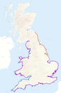 The plan for 2012 is to complete the South-West Coast Path, along with the stretch from Clevedon to the start of the SWCP in Minehead (light blue on the map).
2013 has us striking north from The Wash, across the Humber, Tees, Tyne and Tweed before finally crossing the border into Scotland beyond Berwick (orange).
Will you consider joining us on some of these walks?
This year I'm particularly interested in company for the three thousandth mile, which is likely to be sometime in the Autumn. There will be other events to celebrate too, not least joining up the west and south coasts at Land's End sometime in the summer.
Now that I've shared the plan, I hope I can stick to it. But if events conspire to make that impossible, I can always postpone the "end of England" celebrations another five years.
[Contains Ordnance Survey data © Crown copyright and database right 2011]