Monday, 10 September 2018
Pennine Bridleway
Settle Loop
 Distance: 11.17 miles
Ascent: 555 metres
Duration: 3 hours 30 minutes
Joining up
Although I've completed the current linear Pennine Bridleway, there are still some optional extras left. The Trail includes two loops off the main route, and at about ten miles the Settle Loop is the shorter, providing a good morning walk.
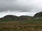
 For twenty years or so I had difficulty locating Malham on a map. It's up a bit of a dead end, and by road it's not particularly near anything. The Settle Loop challenges that perception, extending four miles east of Settle to provide a clear view of Malham Tarn (if not the Cove itself).
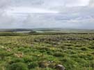
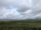 I've really enjoyed "joining up" my knowledge of our island's geography on my walks, and there is no finer example than this. Looking east I remembered my first ever trip to Malham and Gordale Scar, as well as last year's passage through the village on the Pennine Way. On the return leg to Settle the Yorkshire Three Peaks presented themselves proudly on the horizon, reminding me again of last September, but also of this year's walks along the Bridleway. It's deeply satisfying to be able to scan such a wide horizon and see familiar features in almost all directions.
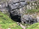 I detoured from the line of the Loop briefly to explore the Victoria Cave, a deep cleft in the limestone.
Its location just couple of miles outside of Settle was evident in that I met about a dozen people walking on these last few miles, but hadn't seen a single soul previously. I prefer the solitude of having the path to myself, but it's always comforting to see friendly faces.