Saturday, 28 July 2018
Gŵyl Coda
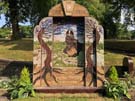
Gŵyl Coda 2018: Gathering Hope
 The Welsh word "bach" translates literally as "small". But it also carries connotations of affection and love. You don't have to be small to have a big impact. Take Wales itself: a small country on our shared island, but with a deep influence.
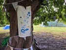
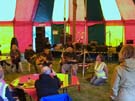
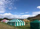
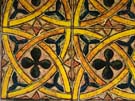 The first Gŵyl Coda festival was held in July this year. Is Coda "Greenbelt Bach"? Perhaps. The family semblance is there: a field with marquees, portaloos and traders; music, theatre, visual art, worship and workshops; a desire to engage with the world's injustices and celebrate its diversities. After listening to Wisam Salsaa talking about Banksy's "Walled Off Hotel", you could grab a falafel from a Machynlleth social enterprise, look at paintings inspired by floor tiles at the nearby Strata Florida Abbey, while in the next tent Nikko Fir sang touching songs of hope in the main Hwb marquee. You get the idea. Anyone familiar with Greenbelt would feel right at home.
Coda is a festival with a strong Welsh accent. Heard in the voices of course, with Welsh language programming forming an essential part of the mix. It's there in the warm welcome; the celebration of Welsh culture, and (perhaps uniquely this year) the buzz of the first Welshman to win the Tour de France.
 Greenbelt has often been described as a community, but really it's a festival that a community of people visit. Coda's taking the opposite approach, existing first as a network of people who amongst other things become visible through a bi-annual festival. The intent is evident in the translation of the festival name: "get up, rise up".
 Coda 2018 was a seed. With nurture and care it'll grow. The next festival will be in 2020, by which time the network will have spent two years working to build positive changes throughout their communities, inspired by the people they've met and the artistic movement they're part of.
England has Greenbelt; Scotland has Solas (next year is the tenth!) and now Wales has Coda.
You're standing on a small island shared by three nations, and now each has a festival of their own that celebrates art, faith and justice. Perhaps visit another.
Monday, 16 July 2018
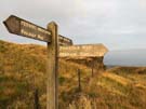
Pennine Bridleway
Diggle → Mankinholes
 Distance: 19.56 miles
Ascent: 1026 metres
Duration: 6 hours 13 minutes
Air
« Not walked | Not walked »
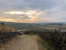
 Incoming inclement weather and a long distance to cover before my train home persuaded me to make an early start today. And so I watched the sun rise over Diggle and Delph as I climbed to the point where the Pennine Way and Pennine Bridleway briefly share a path at the top of Standedge. A disc of sunlight traced across each fell, as if gently waking the villages one-by-one.
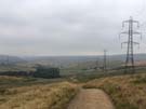
Unfortunately the magic didn't last, the glorious start to the day replaced by dank greyness by the time I'd crossed the M62, and soon I was walking across moorland adjacent to marching electricity pylons, their wires fizzling in the misty air.
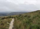
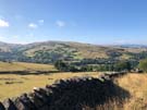
For the first time on the Pennine Bridleway today's leg didn't follow a dismantled railway line at all. But on the final stretch of moorland, another familiar wayfinding mechanism returned: across Langfield Common the line of the path is marked by big flagstones sunk into the ground, a memory of many walks on the Pennine Way. Eventually the mist cleared sufficiently to reveal another old friend — Stoodley Pike Monument — just a shade beyond my destination for the day.
It's been good to get out these four days. I'll be back soon for the next hundred miles or so.
Sunday, 15 July 2018
Pennine Bridleway
Birch Vale → Diggle
 Distance: 21.23 miles
Ascent: 956 metres
Duration: 7 hours 4 minutes
Fire
« Not walked | Not walked »
My original intent had been to walk these four sections of the Pennine Bridleway a fortnight ago, but I put that plan on hold when a week earlier news broke of a wild fire raging on Saddleworth Moor. Today's leg traced the edge of the fire ground.
 Before getting there, I took the "non-bridleway" section of the bridleway. Being a new National Trail, the route isn't yet fully established, and for a section between Cown Edge and Lees Hill there isn't yet a path with bridleway access. Horses and cyclists take to the roads while I followed the "interim" walkers' route. This alternative route followed the sharp line of Coombes Edge, curving high above Charlesworth for a delightful mile or so, but the section wasn't well signposted at all, so I was glad to have checked the line of the path on the National Trails website before setting out. (On the positive side, the route took me past a couple of tremendously-dressed wells just before leaving Derbyshire.)
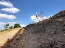 Higher Swineshaw Reservoir provided an excellent point from which to view the fire damaged moors. Framed by the water and the deep blue sky, the blackened land took on an unusually beautiful hue, but after walking a few miles along the Moor Edge Road, with burned heather to the right and luscious pasture to the left the extent of the destruction was clear. Despite that, it was pleasing to see tiny flecks of green amongst the charred earth. It could have been source material for a parable about never being too late to start again.
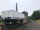
 Eventually leaving the moor, the path dropped to follow yet another disused railway line (they seem to be a feature of the Bridleway) along the Tame valley to the village of Diggle, the southern end of the Standedge canal and railway tunnels under the main Pennine ridge, whose ventilation shafts we saw last year on from the Pennine Way walk.
Notes for future walkers:
- The walkers' alternative is poorly signposted. Check the route before you set out.
- I lost sight of the path on both sides of the A626 Glossop Road north of Charlesworth. Approaching the road from the east I couldn't find the path heading north from SK 010 936, and after crossing the road I ended up on the wrong side of the fence at SK 007 938. This latter mistake seems to be down to a poorly-signed recent re-routing of the path.
- The route at SK 001 947 (The Hague) looks impassable due to an imposing iron gate. There's a similarly huge kissing gate hiding to the left.
- The worst-maintained footbridge I've ever seen is at SK 007 976 in Swallow's Wood Nature Reserve. Thankfully the water level was low and I was able to find an alternative route round the precarious structure.
Saturday, 14 July 2018
Pennine Bridleway
Blackwell → Birch Vale
 Distance: 19.20 miles
Ascent: 683 metres
Duration: 6 hours 41 minutes
Water
« Not walked | Not walked »
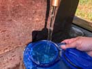 Since the theme of yesterday's walk was earth, today's had to be water. It was set before I'd even taken the bus back out to Blackwell. Staying in Buxton overnight there was only one way I could've filled up my water carrier: direct from the source at St Anne's Well. Like all other wells in the town, it had been dressed for the local festival, a practice I'd not come across before. Apparently a Derbyshire tradition, great frames of wet clay are affixed to the well heads, into which petals, leaves, feathers and all manner of other materials are pressed to create a scene. Had I known more, I would have sought out these wells over the past two walks.
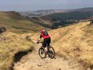
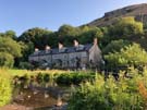 As for today's walk, after a charming start deep in Chee Dale beside the River Wye, most of the first half was a little tedious, plodding along quiet tarmac lanes. On reaching the High Peak though, the trail transformed and became an absolute joy. Ahead I could see Kinder Low, evoking memories of the climb out of Edale last year on our first day walking the Pennine Way. The number of cyclists on the path picked up; some whizzed by, while others stopped suddenly to see what I was photographing (and then seemed surprised to realise that the views were stunning).
 I was hoping to see a monument in Hayfield commemorating the mass trespass of 1932, considered by many to be the start of the movement to secure public access to our country's land, but if there was one I couldn't find it.
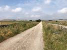
The final stretch of the day from Hayfield to Birch Vale was a little less inspiring, along the line of another disused railway, but was at least very easy walking.
Notes for future walkers:
- Amongst the buildings at Mosley Farm (SK 115 730), the Bridleway turns north away from the drive, but this is easy to miss. If you miss the turn, continue along the drive — the Bridleway soon rejoins it.
Friday, 13 July 2018
Pennine Bridleway
Middleton Top → Blackwell
 Distance: 19.02 miles
Ascent: 164 metres
Duration: 4 hours 55 minutes
Earth
« Not walked | Not walked »
 Yes, I know we've already finished the Pennine Way. This is something different. The Pennine Bridleway is the newest of the fourteen National Trails of England and Wales, and aims to provide a route through the Pennines that can be used not just by walkers, but by horse riders and cyclists too. The route currently stretches 200 miles from Derbyshire to Cumbria, but there are outline plans to eventually extend it to Byrness in Northumbria.
So I'm walking again, hoping to complete the trail over a few weekends this summer.
 Frankly, today's walk hasn't been particularly inspiring. Almost the entire length followed the line of a dismantled railway that was originally used to transport stone from nearby quarries. Stone is everywhere here. In the high fields, clusters of exposed rock reveal the geology that lies just below the surface: fuel for the limestone quarries and brickworks not far from the trail. Had I known about it, I'd have allowed time to explore the National Stone Centre close to the start of the walk. Perhaps another time.
 Another sight I missed was Arbor Low — a neolithic henge about halfway along the route. (Think Stonehenge but with all the uprights toppled. I had no idea such a place existed, which perhaps says more about my ignorance of the centre of our island than anything else.)
The route strikes away from the line of the old railway just ahead of an active quarrying site and heads north across the folds of the landscape towards the main road into Buxton. Hopefully tomorrow's leg will be more varied than today's.
Notes for future walkers:
- To reach the start of the walk at Middleton Top, follow the road from Cromford Station to the crossroad in the village, then continue on the pavement straight ahead uphill (A5012, then B5036). Ignoring the B5035 turning for Middleton Top, continue ahead and take a path on the right just before a railway bridge takes you up to the old line. Crossing over the Steeple Grange Light Railway then pick up the High Peak Trail which runs steeply uphill past the National Stone Centre to Middleton Top.