Saturday, 30 September 2017
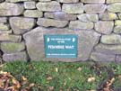
Pennine Way
Tan Hill → Middleton-in-Teesdale
 Distance: 17.26 miles
Ascent: 559 metres
Duration: 6 hours 46 minutes
Halfway
« Not walked | Not walked »
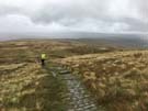
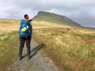
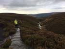
In terms of number of days walking, we've now started on the second half. Our guidebook told us that partway through today's walk we passed the halfway mark in terms of distance too. With no significant injuries to report, it looks like we just might make it to Kirk Yetholm by this time next week.
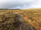
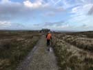
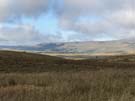
So we set out from Tan Hill with a renewed sense of purpose, although that was tempered by trepidation for what was up first: Sleightholme Moor.
The path here is marked by a sequence of white posts, spread just far enough apart that the next is only visible once its neighbour is reached. Where the ground underfoot isn't a tangle of heather roots it's a peaty bog, and the combined effect of the terrain and the incessant rain made the moor feel endless.
Red grouse had the right idea: hunkering down from the cold wind, oblivious to the fact that their shelters were shooting butts.
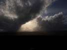
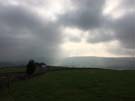
 The rain persisted almost all day.
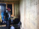
At Deep Dale one end of a gamekeeper's hut is used as a walkers' shelter, and the pencilled graffiti on its wooden walls tell the tales of many who've trod this path before. "The horror!", quotes one, while another simply repeats "the blisters will not beat me" three times as a mantra.
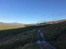
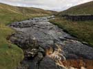
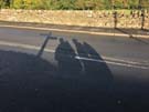 As our shadows lengthened we finally crossed the River Tees and dropped into Middleton. We'd had the briefest of glimpses of the sun, but the forecast for the rest of the week doesn't look good at all.
Friday, 29 September 2017
Pennine Way
Hawes → Tan Hill
 Distance: 16.90 miles
Ascent: 1038 metres
Duration: 7 hours 12 minutes
The lonely Inn on the hill
« Not walked | Not walked »
 My abiding memory of today's walk will be of the last half hour; of climbing up and up, across wet, boggy moorland as the late afternoon sun threw shards of light down onto the hills to the west. It will be of slightly soggy toes, and a sense of leaving villages behind. I will remember the bleakness of the landscape, how we seemed to be heading into the middle of nowhere, and how at the last minute a building came into view. I'll remember taking off my boots outside and walking into the dimly lit bar. I'll not forget the welcoming warmth of the open fires and the equally friendly community gathered there.
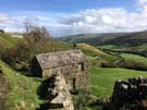
Tonight we're staying at the Tan Hill Inn, the highest pub in Britain.
 The Inn feels like a lonely, solitary survivor, but it hasn't always been out here on its own. The surrounding hills contain coal deposits, which were worked from the end of the 17th century; the Inn provided board and hostelry for the mining community that settled here. When the mines gradually closed during the 1920s the Inn offered accommodation and refreshment to people exploring the moors in newfangled motor cars. We're just the latest in along line of weary travellers.
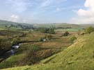
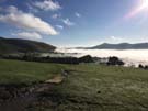
 The climb from Keld to Tan Hill was the second of two today. The other was up and over Great Shunner Fell, which we ascended during intermittent rain. Between the fells the path took us through Thwaite (with its lovely tea room where we sat outside as the rain fell gently into our cups) and Keld (blessed with waterfalls). The villages are linked by Swaledale, the Pennine Way taking a high route through the valley and providing us with the most stunning views so far.
But all this is by the by. Back at the Inn, ale has been quaffed, a giant Yorkshire pudding has been devoured, and we've washed ourselves in brown water drawn from a borehole. Today was all about the destination. Time for bed.
Thursday, 28 September 2017
Pennine Way
Horton in Ribblesdale → Hawes
 Distance: 14.09 miles
Ascent: 502 metres
Duration: 5 hours 27 minutes
Cracking walk, Gromit
« Not walked | Not walked »
Getting out early this morning gave us the opportunity to watch the rising sun strike the terraced side of Ingleborough, which was still swathed in mist after the overnight rain. The heavy showers also meant that the stony path was running with water, and the wet mud was especially boggy. The initial ascent out of Horton had us swiping at clouds of midgies.
 Once on the gentle ascent up to Cam Fell, the views began to open out and we were treated to the thundering sound of Sell Gill Beck pouring its brown, peaty waters into one of the celebrated potholes in this area of limestone country. It was tempting to look down into the cavern, with its fringe of ferns, but the obvious danger held us back.
 This isn't a stand-out walk in terms of major landmarks, but it more than makes up for it with panoramic views across the surrounding fells. Standing on the ledge of Dodd Fell felt like being on the edge of the sky.
 Heading down the valley into Hawes, we crossed several muddy, boggy fields, before making it into the small town. It's the home of the famous Wensleydale cheese, so a trip to the "cheese experience" visitor centre is essential (and not just for the plentiful free samples). Wallace would approve.
Wednesday, 27 September 2017
Pennine Way
Malham → Horton in Ribblesdale
 Distance: 15.82 miles
Ascent: 963 metres
Duration: 6 hours 24 minutes
Limestone country
« Not walked | Not walked »
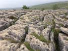
Malham Cove and Pen-y-Ghent are two of the Yorkshire Dales' big-hitters. Today's walk started at the former and finished at the latter; it was bound to be a gem.
Unfortunately the weather was also characteristically Yorkshire. While it remained dry, low cloud and high winds reminiscent of our walks across the moors earlier in the week meant that we didn't get the classic views that postcard creators crave.
In fact, although our guidebook has promised views of Pen-y-Ghent for days, we didn't see it until we began the descent of Fountains Fell, the preceding hill. As we reached the summit of Fountains, the mist cleared briefly to unveil the challenge that was up next, before hiding it once more.
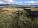
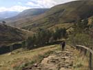
 And what a challenge. Climbing the southern ridge is an exciting way to ascend Pen-y-Ghent: a tough, stepped approach with a short section of light scrambling. With the wind doing its best to throw us from the rock, our hearts raced until we finally reached the summit plateau, the highest point along the Way so far. After a brief shelter from the wind, we took the long, slow, gentle track down the hill and across the moor to Horton.
Today we've enjoyed the best limestone scenery despite the weather.
Notes for future walkers:
- The ascent of Pen-y-Ghent from the south is much more interesting than the laborious slog from the west, but handwork is necessary.
Tuesday, 26 September 2017
Pennine Way
Ickornshaw → Malham
 Distance: 18.36 miles
Ascent: 746 metres
Duration: 7 hours 6 minutes
Muck and Manure
« Not walked | Not walked »
Our guidebook tells us that Wainwright suggested this leg of the walk was "mostly muck and manure." For once, we're inclined to agree with the much-overrated grouse. Today has been spent walking through rolling farmland, but that doesn't sum up the grubbiness of what we've encountered. (As we left last night's B&B we were advised to don gaiters. It was good advice.)
 The first mucky moment was an ill-judged footing near a field gate. What I expected to be a veneer of mud on top of a concrete track revealed itself as a thin crust on an ankle-deep soup of cattle effluent. Later we crossed a field which was in the process of being sprayed with liquid manure. The stench was so laden with ammonia that we had to work hard to suppress our gag reflexes as we dashed for the other side. For the rest of the day the smell of cattle seemed to follow us everywhere, and each cow we passed seemed to be in on a joke from which we were excluded.
 There were of course highlights. Among them were crossing into the Yorkshire Dales National Park and the walk along the River Aire. But by far the best moment when the limestone escarpment finally came into view, revealing Malham village above the bubbling Aire, framed by the dominating backdrop of Malham Cove and Goredale Scar.
At last we've reached that we've both visited before. Tomorrow the familiar scenery should continue, hopefully with a little less muck. (Thank goodness for YHAs with outdoor taps and drying rooms.)
Monday, 25 September 2017
Pennine Way
Blackshaw Head → Ickornshaw
 Distance: 15.40 miles
Ascent: 706 metres
Duration: 6 hours 28 minutes
The wind-blown moors
« Not walked | Not walked »
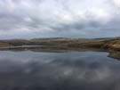
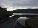
We started today's walk in mist and drizzle, which only started to clear once we'd made it to Wadsworth Moor. The surface of the Walshaw Dean reservoir became a clear reflecting mirror, an idyllic blue that almost overcame the memory of the traipse over soft ground to reach it.
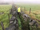
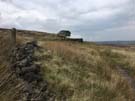
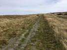
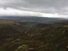
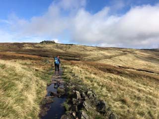
 Much of the day has been on high moorland; heather and rushes thriving in the boggy ground. At various places flagstones have been laid to make life easier for those following the National Trail; not only do these provide a solid path across the wettest sections, but they also act as reassuring navigational aids on expanses of land devoid of obvious features. Today was our first real experience of the wettest bogs of the route, and we're now learning how these areas of ground slow us down and make for tricky, unreliable walking.
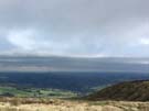
 The sun didn't last long — the low clouds returned on cue to add dramatic lighting to the most evocative section of the walk over Withins Height. Top Withins is thought to have been the inspiration for Emily Brontë's Wuthering Heights. Its setting is certainly dramatic enough, but the many paths which lead to the now-ruined farmhouse don't come close to the bleakness experienced later in the day.
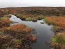 It didn't help that the drizzle returned during the later stages of the walk, but cold, boggy Ickornshaw Moor seemed to stretch on forever; clumps of brownish heather hiding deep, water-filled peaty gulleys. There are several standing stones marked on the map close to the path but either the mist, or the end-of-walk tunnel vision, meant that we didn't see them. It was a relief to finally head downhill into the fields around Cowling, and the sight of neat rows of terraces marking the end of the walk.
Sunday, 24 September 2017
Pennine Way
Standedge → Blackshaw Head
 Distance: 17.19 miles
Ascent: 616 metres
Duration: 6 hours 39 minutes
It's Grim Up North
« Not walked | Not walked »
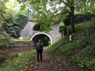
 While the previous two days have been mile upon mile of desolate moorland, today, human attempts to tame the landscape have been very visible, starting with the ventilation shafts for the Standedge Tunnels that were visible from the conservatory of the Carriage House Inn where we spent the night. These tunnels are amongst the longest and deepest in the country, three carrying railways while the earliest is a canal tunnel. The audacity of the Victorian engineers in deciding to carve a hole through four miles of solid rock is awe inspiring.
 Two other cross-Pennine routes from different eras came later. First was the M62 motorway (which will forevermore remind me of the JAMS' industrial dance single "It's Grim Up North" as well as our friend John Davies' walk ten years ago). Then a little later we found ourselves on the cobbled remains of a Roman Road, a critical trade route.
Throughout the day we've seen reservoirs; some built to feed the canals while others supply fresh water to the northern conurbations of Manchester, Burnley and Rochdale.
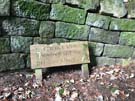
 The last landmark of the day was a different affair altogether. Standing proud on Stoodley Pike is a needle-shaped column intended to celebrate peace won after the Napoleonic battles, though I get the feeling it was more a monument to military might than a call to laying down of weapons. If you intend on climbing the monument, be sure to take a torch -- there's no illumination on the spiral staircase that leads to the balcony.
Today's stretch of the Pennine Way ends just above Hebden Bridge, a former mill town, and it's hard to imagine, given its green setting today, how it would have looked with black smoke belching from the chimneys of the many industrial works, steelyard and cotton mills. Although the loss of industry has shaped the town, it's tempting to think that the change has been a good thing overall.
Tonight, we're staying in a B&B on a sheep farm just outside Hebden Bridge, which we got to after walking along steep, narrow footpaths up the hillside. We've been treated to hot baths and a delicious home-cooked meal of roast lamb and vegetables ("everything's our own except the tatties"); a satisfying end to a tiring day.
Saturday, 23 September 2017
Pennine Way
Torside → Standedge
 Distance: 13.04 miles
Ascent: 776 metres
Duration: 5 hours 43 minutes
Community
« Not walked | Not walked »
 "How did you get on today?", asked the woman at the bar. "You know, with your walking." I didn't recognise her without her bulging rucksack and red hat. We'd talked yesterday shortly out of Edale. It was easy to spot the Wayfarers then, full of enthusiasm. Pragmatism has stuck in now, with the wild campers shedding excess food, the B&Bers thinking about baggage transfer services and everyone realising there's a long way to go yet. I suspect we'll meet up every now and then in pubs and youth hostels; share tales from the trail, but otherwise be very British about things (even now, we don't know each others' names).
 Many reviews of the Pennine Way describe the first two days as the toughest, and it's not hard to see why. Today, the path started with a slog up a stony track to crest Laddow Rocks, before creeping along the edge of a cliff overlooking Crowden Great Brook. After a gentle descent along sometimes narrow and rocky paths, criss-crossing fords through the Brook, we ascended the rough, bleak and boggy Black Hill, before making our way back down to the A635. A beautiful vista opened out from the top of the Hill: as West Yorkshire came into view we could make out Emley Moor Transmitter (the UK's tallest freestanding structure), a large power station, and a wind farm outside Holmfirth. There was a deep clough to cross on the way down, with a typical knee-wearying descent and ascent along steep, slippery tracks.
 The way ahead, around the north of Wessenden Moor, was easier. Reservoirs came into view, acting as useful waymarks in what otherwise seemed like featureless moorland; the never ending Blakely Clough, which separates Black Moss and Swellands reservoirs, was particularly monotonous.
Near the end of the walk we passed a roadsign declaring this to be Saddleworth Moor, a vast expanse of moorland, which it is widely believed holds the as-yet undiscovered grave of one more of Ian Brady and Myra Hindley's victims. The Moors Murders took place round about the time that the Pennine Way was opened.
As our heads hit our pillows in the Carriage House Inn our new friends are comparing camping gear in the pub's garden. It's rare for us to find this level of community in our walking routes; hopefully, we'll see them throughout the week.
Friday, 22 September 2017
Pennine Way
Edale → Torside
 Distance: 15.63 miles
Ascent: 843 metres
Duration: 6 hours 55 minutes
Starting out
« Not walked | Not walked »
Here goes then: our first attempt at walking the UK's first National Trail. The Pennine Way was opened in 1965 and stretches for 250 miles from Derbyshire to the Scottish Borders. All being well we'll have a celebratory half pint in Kirk Yetholm two weeks tomorrow.
 And it started so well! A low cloud inversion hung in the Hope valley as we climbed out of Edale. The village where the Way starts is currently hosting Bogfest 2017, which features an organised walk along half of our route today, so we set off early to avoid the crowds.
 Almost immediately we climbed strenuously to the plateau of Kinder Scout, a hill that's taken on the mythical status as the birthplace of the Right to Roam movement eighty-five years ago. It was a further sixty-eight years before the Countryside and Rights of Way Act 2000 made a good start on the campaigned-for rights in England and Wales, but south of the border we're still way short of the world-leading access rights conferred by the Land Reform (Scotland) Act 2003. For a hill that has such significance in social history, we'd expected it to feel more significant in some way; in reality, the hard slog up its stony flank removed any romantic notions that we may have had.
The map suggested that after the initial climb, the remainder of the walk would be easy: a scamper along the plateau and then a descent into Torside.
What we'd not bargained on is how complex that "along the top" walk would be. The Way is the least well waymarked of any National Trail we've seen so far and even when on the correct route, each step needs to be carefully considered since the ground is in equal parts peat bog and rough rocks. To be fair there are lengthy sections laid with flagstones too, but the other parts slowed our pace severely. On this stretch the comical call of the occasional grouse lifted our spirits slightly. What other animal quite literally shouts "quack"?
 Route finding is tricky for other reasons too. On top of Bleaklow Head there are very few visible landmarks and the ascending path is hidden in a deep cleft. It started to rain on this section, and the intermittent drizzle persisted for the rest of the walk.
The highlight of the lengthy descent at the day's end was a friendly black and white cat on the valley floor who had been patiently watching us make our way down, ready to welcome and love anyone who'd stop to say hello.
So there you have it. Fifteen miles down, two hundred and thirty-five to go. We have started; when will we finish?