Friday, 10 March 2017
Offa's Dyke Path
Sedbury Cliffs → Chepstow
 Distance: 1.94 miles
Ascent: 98 metres
Duration: 36 minutes
A prelude
« Not walked | Not walked »
Here's the plan: over the next twelve days I'll walk the length of Offa's Dyke Path. It's the only National Trail in Wales that I've not completed, and when I reach Prestatyn a week on Wednesday it'll join up with my walk round the Welsh Coast to create the longest circular walk I've done so far.
 This time I'm on my own. Emma's at work, and although I enjoyed Mum's chauffeuring (and company) on Glyndŵr's Way last year, I decided to try and complete this walk unaided. I've booked accommodation for each night, and I intend to not use any form of transport other than my two feet until I reach the north coast.
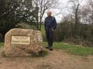
The path itself starts incongruously on a cliff north of the Severn Bridge. It's a seemingly arbitrary point until you realise that there really is a Dyke and it is here, where the land meets the sea, that it finishes.
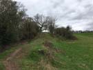
 After a short walk along a segment of earthwork, the two miles into Chepstow aren't particularly inspiring save for the fact that they're the start of a big walk, and the north coast beckons.
 Perhaps of more interest is how I reached the start. I looped around Beachley Point, where the Wye and Severn kiss and make up after their race from the summit of Plynlimon.
Wales Coast Path
M48 J2 → Chepstow
 Distance: 2.86 miles
Ascent: 111 metres
Duration: 52 minutes
A coda
« Not walked | Not walked »
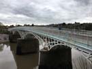
Five years after completing the Wales Coast Path, how do I find myself finishing it again? Back in January 2012 we crossed into England on the Wye Bridge, but the Coast Path that was officially opened later that year has its formal end point a couple of miles further up the Wye in Chepstow. It makes for a more attractive end, rather than the somewhat abrupt mid-bridge stop indicated only by a motorway marker post.
But I'm a completer, so the little chunk from the Bridge to Chepstow has been teasing me for too long.
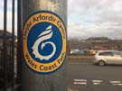
The path is extremely well signposted, with the Coast Path's stylised dragon logo appearing at reassuringly frequent intervals on lamp post stickers, finger posts and even discs embedded in the pavement. Whenever I was unsure of where the route went next I needed only look briefly for the next waymark.
 A mural set into the riverside path by The Boat Inn is the official end. It's somehow unsatisfactory. Perhaps this is because the upright stones on either side indicate the bigger walk on my mind.