Sunday, 11 September 2016
Coastwalk
Rosemarkie → Cromarty
 Distance: 12.77 miles
Ascent: 321 metres
Duration: 4 hours 53 minutes
Uncovering the past
« Inverness | Nigg Ferry »
The first part of this walk – from Rosemarkie to Eathie – has to be one of the greatest coast-walks in the country. The beach is completely covered at high tide, so pick a day when you'll be able to complete the four or five mile stretch on a falling tide.
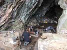 About forty-five minutes after setting out we came across an archaeological dig. Volunteers from the Rosemarkie Caves Project were finishing off a week excavating one of the many caves in the area. They'd dug down a good couple of metres, revealing the full extent of an old wall that once enclosed the mouth of the cave. What excited them most was the discovery of metal-working at one point of the cave.
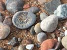
Our peak excitement came a good distance further along the beach. We'd heard it was good for finding fossils, and one of the archaeologists pointed out the types of stone to be looking for. We picked up plenty of similar pebbles but uncovered nothing until Emma stopped to take a photograph of me. While I waited for her to rejoin me, my eyes fell to the beach at my feet and there – not a metre away – was the classical spiral shape of an ammonite fossil, face-up in the sand.
 Fossil in pocket we continued, eventually leaving the beach by the steep zig-zag path through the pine woods above Eathie Fishing Station.
This path is said to have been constructed by Hugh Miller, who by all accounts was a remarkable man: stonemason, folklorist, reforming Christian, geologist. The house in Cromarty where he lived is now a museum, but unfortunately we didn't find out about him before we'd left so missed the opportunity to learn more.
 From Eathie we walked on the road through Navity to Cromarty Mains Farm, where we picked up the clifftop path towards McFarquhar's Cave. Instead of visiting the cave we turned north to round Gallows Hill, and picked up the descent into Cromarty from South Sutor.
Moments after arriving the bus to Inverness pulled in and we began our long journey back south. It was a fantastic weekend.
Notes for future walkers:
- The path between Rosemarkie and Eathie is impassable at high tide; we set out five hours before a 1.8m low tide at Cromarty and had no trouble.
- Don't lose faith approaching Ethie — you'll find the fishing station and path readily enough.
- From the car park above Eathie Fishing Station (NH 768 635) we followed the minor road north-east past Navity and took the track on the right at NH 782 657 to Cromarty Mains Farm.
- From Cromarty Mains Farm we took the track south-east signposted to McFarquhar's Cave. When we reached the band of trees at NH 797 657 we entered the field ahead and to the left and followed its left-hand edge to the stile at NH 803 659. It's also possible to reach this point by continuing along the band of trees to the bottom edge of the field before turning left.
- The track from NH 803 659 to the car park on South Sutor at NH 808 671 isn't very well defined on the ground, but the general direction is easy enough to follow.
- From the top of South Sutor a good network of footpaths head north, then west through the wooded slopes to Cromarty itself. We turned left at a junction at the bottom of a steep section, then took the right fork a little further on and that seemed to work. Follow your nose!