Tuesday, 22 March 2016
Coastwalk
Gardenstown → Portsoy
 Distance: 18.39 miles
Ascent: 426 metres
Duration: 5 hours 43 minutes
Seatown
« Fraserburgh | Portgordon »
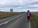
Today's been another long day of road walking, but hopefully it'll be the last such day this week. In fact, it was nearly entirely roads with only the first couple of miles out of Gamrie offering anything like enjoyable walking.
 Most of the coastal settlements along this stretch of coast are made up of multiple distinct communities. In almost every case there will be a cluster of houses packed right up against the beach called Seatown. The architecture is distinctive: low one-and-a-half storey stone houses, gable-ends presented to the sea, seemingly constructed in a slightly haphazard arrangement on whatever land was available.
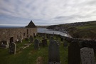
Harbour Road in Gamrie leads to Seatown, and it'd be another nerve-racking drive for those foolish enough to try it, just like in Crovie. Eventually the road ends at a car park and the path drops to the delightful beach, at the far end of which a path leads up to the old kirk.
Gardenstown has at least half a dozen churches but St John's Kirk was the first. On a section of the harbour wall is the painted declaration "God is love".
The path up the hill had suffered in the storms earlier this year, and coupled with the overcast windy weather and the experience of walking through Seatown it's easy to see how much faith was a comfort to those living here.
 Past the kirk we were on roads to Macduff, but thankfully mostly with good visibility. A cycle track between Banff and Whitehills provided a little relief. Downies of Whitehills has a fresh fish counter but we passed by without purchase.
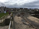 Then onto the roads again — albeit quiet local ones this time — before the final descent into Portsoy. The harbour at Portsoy looks charming but we didn't explore much; we were keen to get back to the cottage and besides, we'll be here again tomorrow.
Notes for future walkers:
- Follow the beach west out of Gamrie, then pick up a path up to the churchyard that leaves the beach at Kirk Burn.
- We walked to Macduff along the B9031 (with a small diversion onto a local road past Mains of Melrose for a breather), then the A98. It is almost certainly possible to find a better route through the fields starting above the church. From Banff an excellent cycle track leads to Whitehills.
- You can regain the prom (High Shore) from the A98 (Buchan Road) by tucking down an alley behind the Royal Tarlair Golf Club just before the first house in Macduff.
- From Whitehills we took the minor road west out of the village to NJ 644 646, then the B9139 to NJ 597 657, at which point we took the track north north-east to the cross tracks at NJ 598 660 where we turned left down a steep track signed to Back Bay. While this took us off the roads, it was very wet and not a great idea.