Wednesday, 30 September 2015
Saturday, 26 September 2015
Coastwalk
Newburgh → Cruden Bay
 Distance: 12.38 miles
Ascent: 247 metres
Duration: 4 hours 4 minutes
One more church
« Bridge of Don | Peterhead »
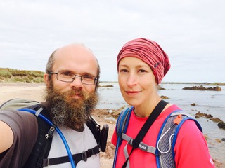
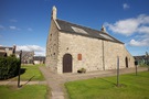
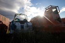
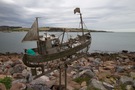
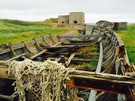
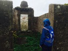
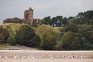
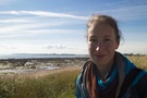
We've already walked further than we'd planned this week, but there was still time for one more outing, one more abandoned church.
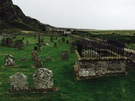
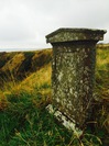
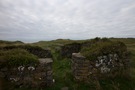 Local legend is rife with tales of how the medieval village of Forvie came to be buried in the sand. All that remains now are the forlorn four walls of the church. It's a haunting spot, but there's little here to indicate that the building was a place of worship. I prefer the churchyards we've seen elsewhere this week.
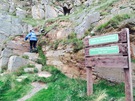
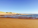
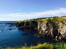
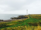
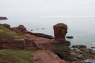
At the church the sandy interlude that began in Aberdeen comes to an end. Before we reached the village of Collieston, the rocky terrain had asserted itself against any attempts to tame it with a straightforward path. The way out of the village started with a clamber up a steep rock face.
 Though a formal path at this point, it was of poor quality and so when we reached Old Slains Castle we switched to the backroads despite a sign indicating that the path ("Sponsored by Energetica") would continue to Whinnyfold.
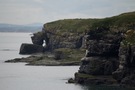
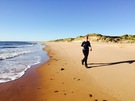
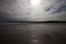
 We were racing against the clock: the map suggested that the beach at the Bay of Cruden might be tricky at high tide so we were hoping to get there early. In the end we reached the beach more-or-less bang on high tide, and didn't have any difficulties - other than dodging the jellyfish that had been washed onto the sand.
We've had a great week here in the north-east of Scotland. Next time we'll turn the corner towards Inverness, and from there John O'Groats seems only a short hop away.
Notes for future walkers:
- We followed the well-marked track across Forvie National Nature Reserve from the car park at NK 004 270 through NK 004 268 and NK 011 269 to Forvie Church at NK 020 265.
- From Forvie Church a good clifftop path leads to Collieston.
- In Collieston drop down to the harbour as soon as possible; a path leads through the Low town to the car park on St Catharine's Dub
- A well marked path starts at the car park heading for Old Slains Castle but begins by clambering up the rock.
- From Old Slains Castle (NK 051 300) another signposted path claimed to follow the coast to Whinnyfold but we were pushed for time so stuck to the roads (NK 048 301, NK 045 305, NK 047 308, NK 068 325, NK 069 325, NK 077 334, NK 081 332).
- At Whinnyfold we rejoined the clifftops, soon dropping to the beach at the southern end of Cruden Bay (NK 083 338).
- It looks as through the beach at the Bay of Cruden can be walked at all states of the tide; despite planning to the contrary we reached it near high tide and didn't have any trouble.
Friday, 25 September 2015
Coastwalk
Aberdeen → Bridge of Don
 Distance: 4.88 miles
Ascent: 33 metres
Duration: 1 hour 38 minutes
The Fittie Squares
« Muchalls | Newburgh »
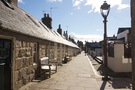
Last year I saw a BBC documentary about the "Fittie Squares": a two-hundred year-old purpose-built fishing community at the mouth of the River Dee (the area's official name is Footdee), built as three inward-looking squares of small stone houses with a Mission Hall at their heart.
Since then I've been looking forward to this, the second of two walks today.
 The Squares were everything I'd hoped they'd be: beautiful, charming and functional. We were keen not to hang around too long: they're not a tourist attraction, they're people's homes.
The documentary also tells the story of how Big Business in the form of oil resulted in the destruction of Fittie's twin village at Old Torry. ("Global oil giant Shell, already leasing a plot nearby, had threatened to leave Aberdeen if the land at Old Torry was not made available to them".)
The parallels with Trump's demands on the land and sea near his golf course seem all too clear.
After Footdee we were on the prom the rest of the way round to Bridge of Don where we started this morning's walk. Halfway we passed a man in hiking boots and a kilt. If the squares wanted to be left alone by the tourists, I got the feeling that this gentleman didn't.
Coastwalk
Bridge of Don → Newburgh
 Distance: 11.16 miles
Ascent: 29 metres
Duration: 3 hours 1 minute
Where the Ythan meets the ocean
« Aberdeen | Cruden Bay »
 (In order to fit in with the tides and public transport logistics, we've split today's walk into two parts and walked them "out of order". This is the more northerly of the two walks, but the one we did first.)
There can be few walks better than this morning's.
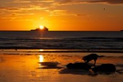
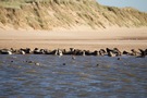 We were on the beach within metres of leaving the car, stayed on the sand for ten linear miles, passed only one other person, watched the sun rise over ships at sea then finished by a seal colony at a river mouth. (When the seals noticed that we'd stopped to watch them they splashed into the water a dozen at a time to get a closer look at us.)
But there was a catch.
(There's always a catch.)
Behind the dunes in recent years a struggle has been going on, and of late it seems the vandals have won. From the beach it's visible in one place, where the subtle tones of the marram grass are rudely interrupted by a garish green.
 If you don't know the story of the bulldozing of the Menie Links by an egotistical American businessman, watch Antony Baxter's films You've Been Trumped and A Dangerous Game. Or read our friend Alistair McIntosh's bardic declamation, O Donald Trump, Woe Donald Trump or relevant posts on land expert Andy Wightman's blog.
We just hope that Karine Polwart's vision comes true, that natural forces will cause the dunes to reclaim the greens:
The tide still ebbs and flows
where the Ythan meets the ocean.
Not even God himself
could stop the northerlies from blowing.
You can tear these dunes asunder,
pound this wonder into dust
with your cruel hands and crooked hearts
laden with lust and expensive lies
but the haar will stumble in to cover your eyes.
The haar will stumble inKarine Polwart - Cover Your Eyes
Notes for future walkers:
- We saw no indication that the beach beneath Blackdog Ranges is ever closed.
- Leave the River Ythan by the boathouse to find the golf club road.
- Where the road bears left (NK 000 249), pick up a path running north to a bridge over the Foveran Burn at NK 000 252. (The footbridge further to the north seemed to be closed.)
Thursday, 24 September 2015
Coastwalk
Muchalls → Aberdeen
 Distance: 15.41 miles
Ascent: 397 metres
Duration: 5 hours 16 minutes
Granite City
« Inverbervie | Bridge of Don »
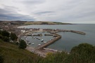
Aberdeen is our target for this year's walking, so we're delighted to have reached Granite City with a few days left in the week.
The city simultaneously impressed and disappointed, much as the whole of today's walk has.
 Thick cloud foiled this morning's attempt to watch the sun rise over the North Sea, so our early start was in vain. This was no bad thing though: there was nowhere on the early part of the walk that gave a suitable vantage point to the east. Instead we found ourselves alternating between farm track and roads until we finally reached the boundary between Aberdeenshire and the City of Aberdeen. Almost surreal was the moment we found ourselves amongst hundreds of life vessels that were being serviced before redeployment on rigs at sea.
 At this point (Cove Bay) a good quality coast path began. Clearly the City council's attitude towards coast walkers is more welcoming than the county council's. (Or is it just that they have only ten miles of coastline while the county has more than ten times that distance?)
The path wound its way past the comically-horned animals of a rare breeds farm and finally reached the open sweep of Nigg Bay. On the map this looked charming: soft sand, obligatory disused church, and a lighthouse at the far side. In reality it was messy and smelly, with a refuse tip and industrial works dominating one end.
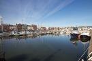
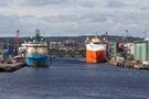 The lighthouse marked the start of Aberdeen Docks and as we turned the corner the city revealed itself. Or rather, it would have except that it seemed to be hiding behind huge ships and dock buildings.
What about the granite? We certainly saw plenty — every building here seems to be made of it, from the lowliest bungalow to the grandest of civic centres. (One wonders whether affluent locals are proud of brick kitchen work surfaces the way granite is prized in the south!) But as interesting as the uniform material is, it lends everything a dull greyness as if the whole town is weeping.
I won't let that be my lasting memory of the city though. Instead, let me remember the fingerpost sign I saw by the docks: "Ferry to Northern Isles"; we really are a long way north.
Notes for future walkers:
- A good track north from Muchalls via Mains of Monduff leads to Newtonhill.
- Cross the railway in Newtonhill and follow Skateraw Road to its end where a path to the left runs down to the bridge at the back of Newtonhill Bay.
- Cross the bridge and continue in the same direction up a steep path to join the track that contours around Cran Hill at NO 916 938.
- Farm tracks lead on from NO 918 944 to cross the Burn of Daff (NO 920 946) and reach Downies (NO 923 951), then from NO 925 950 through NO 928 960, NO 929 959 to Porthlethen Village (NO 930 962).
- From the end of the road in Porthlethen (NO 935 963) we followed field-edge paths to the life-vessel refitter (NO 936 969).
- Through Findon and Cove Bay we were back on roads: NO 937 973, NO 938 974, NO 938 977, NO 939 984, NJ 939 002, NJ 952 008, NJ 952 013 to NJ 953 015.
- At NJ 953 015 a good path runs back to the clifftops and then north all the way to Nigg Bay. (A signpost suggests that this path might in fact begin further south at Cove Bay Harbour.)
- We stayed beneath the road around Girdle Ness most of the way to the breakwater, but felt that the road would've been a better choice.
Wednesday, 23 September 2015
Coastwalk
Inverbervie → Muchalls
 Distance: 17.93 miles
Ascent: 451 metres
Duration: 5 hours 37 minutes
Births
« Montrose | Aberdeen »
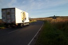
The research we did before heading out this week always suggested that today would be tedious. It certainly was. We should have been celebrating our most northerly coast walk so far, but instead found ourselves trudging mile upon mile of road, ranging from quiet back streets to a busy dual carriageway.
 So let's instead consider some local births.
The street signs welcoming you to Inverbervie declare it to be the birthplace of Hercules Linton, the designer of the Cutty Sark. Beside the Bervie Chipper a replica of the ship's figurehead regards the A92 with suspicion.
 Not to be beaten, Stonehaven's signs lay claim to the birth of R.W. Thomson, "inventor of the pneumatic tyre". I think the town council would rather that contribution to modern life be remembered more than the one declared on a banner hanging from the side of one of the town's chippies, for it was the Carron Fish Bar that's said to have originated the Deep Fried Mars Bar.
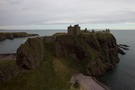 (If you're ever in the area, don't miss Stonehaven. It's the nearest town to where we're staying this week and we've come to really appreciate its large market square full of independent shops and cafés. The Tolbooth Museum — where the staff urged us to come and live north of the border — is also worth a visit, as is Dunnotar Castle. And of course at Hogmanay there's the fireballs.)
To the north of Stonehaven is Cowie. This village seems to be mainly caravans, but it was here ten years ago that a fossil of the world's oldest living creature was found. At 428 million years I don't much fancy putting the candles on this millipede's cake!
Notes for future walkers:
- We didn't even try to find a coast path out of Inverbervie but instead followed the A92 north, leaving it at NO 838 742 where we began to follow Sustrans route 1 through NO 854 751, NO 857 763, NO 856 772, NO 860 782, NO 865 786 and NO 868 785 to NO 871 799 where the cycle path heads inland to cross the A92. At this point we stayed on the unclassified road through NO 876 805 and rejoined the A92 from NO 873 810 to the next unclassified road at NO 874 834.
- From the car park (NO 875 837) for Dunnotar Castle an excellent path leads back to the coast and then north to the outskirts of Stonehaven.
- From behind the Tolbooth Museum in Stonehaven harbour a good board walk then promenade runs along the back of the beach as far as Cowie.
- At Cowie we picked up a clifftop path to the abandoned chapel at the southern end of the golf course (NO 884 873).
- From the golf club access road (NO 883 873) we stayed on the road to join the A90 at 889 885)
- There is a pavement alongside the A90 but it doesn't make for pleasant walking.
- We left the A90 at NO 897 913 (signposted Mill of Muchalls) but don't advise this; after walking in a loop around Doonie Point we eventually found the path north from Easter of Muchalls but it was incredibly overgrown. Better to stay on the A90 to Walker Drive (NO 899 919).
Tuesday, 22 September 2015
Coastwalk
Montrose → Inverbervie
 Distance: 18.80 miles
Ascent: 242 metres
Duration: 6 hours
A tale of two counties
« Braehead of Lunan | Muchalls »
One third of the way through today's walk we finished the Angus Coastal Trail and started on Aberdeenshire. Angus benefits from a published guide book, but the best Aberdeenshire can rustle up is the promise of work yet to come. I suspect the council priorities are elsewhere right now.
 We'd get to Aberdeenshire in good time, but first we had to leave Montrose. On the quayside there's a huge statue of a dog. Bamse seems to have become a local hero during the second world war, and his statue certainly supports that, but his grave is tucked away in sand by the corner of a high security fence. It's a curious sight, as if the council don't quite know what to do with it.
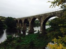
 Our remaining time in Angus was along the wide sands of Montrose Bay, eventually cutting inland past a derelict bothy to a pair of beautiful viaducts that led us into Aberdeenshire.
 Abandoned churchyards seem to be a regular feature of the east coast of Scotland. Today's was beneath the village of St Cyrus and in the dank air its isolation and sorrow were very potent.
Overgrown paths and muddy fields with no exits slowed us down so we were pleased when we finally found the cycle path that runs through a few of the coastal communities here. If today's route-finding is anything to go by, Aberdeenshire will be a challenge.
Notes for future walkers:
- The way to the shore on the River North Esk is relatively easy to find — follow the signs to Bamse's grave.
- At high tide the beach is impassable alongside Traill Drive but the road provides a quiet alternative. Drop onto the sand where the road bears inland at NO 727 582.
- We left the beach at NO 738 617; there's an abandoned farmstead here just behind an obvious gap in the dunes. We then followed the track west north-west to the edge of the plantation at NO 734 618, then north — staying outside of the trees — until meeting the river. Running west from NO 734 621 a track, then a narrow path, follows the river to the viaducts of Lower North Water Bridge.
- Cross the old railway viaduct, then circle down left to the road running to the visitor centre at Cocklem Bents.
- We left the track that runs at the foot of the Heughs of St Cyrus by the zig-zag path that climbs from NO 753 646, although there appears to be another exit from the beach further to the north that meets the clifftops at Woodston Fishery (NO 756 649).
- We failed to find a way across the Woodston Burn gully and ended up rejoining the road through Nether Woodston to the A92.
- Rejoin the coast at Tangleha' Cottages (NO 771 650) by taking the road that leaves the A92 at NO 759 657.
- Between Tangleha' and Milton of Mathers, follow the foreshore initially but keep an eye out for a path that eventually becomes distinct at the back of the beach.
- Beyond Milton of Mathers a decent coast path and eventually cycle path leads the rest of the way to Inverbervie.
Monday, 21 September 2015
Coastwalk
Braehead of Lunan → Montrose
 Distance: 8.33 miles
Ascent: 125 metres
Duration: 2 hours 45 minutes
A life lived backwards
« Arbroath | Inverbervie »
We need to zip over to Glasgow this afternoon, so it's been an unusually short walk. This has been no bad thing since the weather has turned dreich and we've only one pair of waterproof trousers between us. While Emma's in the Solas board meeting I shall be shopping!
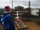
 The day started with two miles of road walking before we rejoined the coast at Boddin Point, one of many abandoned communities on the edge of the land. An overgrown path brought us to a cemetery above Elephant Rock. Amongst the lichen-covered tombstones is one for George Ramsay that declares he was born in 1859 but died nineteen years earlier in 1840!
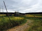
 The faint path took us on, along the clifftops, to the farm at Mains of Usan with its curious derelict mausoleum.
From the farm a much better track took us the rest of the way to Scurdie Ness Lighthouse, which guides ships along the River South Esk to the busy docks at Montrose.
Notes for future walkers:
- The path from Boddin to Elephant Rock starts on the landward side of the house above Boddin Point at NO 713 535.
- It is possible to continue along the clifftops east of Elephant Rock; the path begins to the north of the cemetery.
- At Usan we dropped down to the harbour, but shortly afterwards had to walk north north-west to pick up a track that runs between Seaton of Usan and Rashick Knap. It might be better to ignore the harbour and join this track at NO 723 545.
- From Rashick Knap walk through the fields to the ruined mausoleum (you can see its curious outline a way off).
- We used the foreshore behind the mausoleum at Mains of Usan (NO 729 557) to give access to the next field through which runs a track to the lighthouse.
Sunday, 20 September 2015
Coastwalk
Arbroath → Braehead of Lunan
 Distance: 13.08 miles
Ascent: 299 metres
Duration: 4 hours 19 minutes
Smokie
« Carnoustie | Montrose »
 The first six miles of this walk are very popular. North of Arbroath the red sandstone cliffs have eroded into stunning stacks, arches, caves and blowholes. Angus Council publish an excellent Geodiversity Trail leaflet describing the route and its geology in great detail. A highlight for us involved a diversion for 100m or so into a field to Gaylet Pot - a deep hole where the roof of a cave has collapsed and from which emanated the sound of unseen waves, a long way below.
The smokie shops of Arbroath weren't open as we set off. It's said that the smokie actually originated in Auchmithie, the village at the northern end of the Geodiversity Trail, but that its technique was taken south to Arbroath in a mini economic migration.
 Beyond Auchmithie we were on farm tracks and fieldside paths past Red Head and Ethie Haven before dropping down to the sands of Lunan Bay at Corbie Knowe. A couple passed us asking whether the route they were on would take them to Auchmithie. As locals they'd been exploring the coastline themselves over the years and it seemed clear to me that walking in Scotland will take the form of exploration more than following a path.
 Lunan Bay is expansive and well known, but quite quiet at the southern end. Towering above the beach to the west is the ruin of Red Castle, guarding the mouth of the Lunan Water which we splashed across to reach the more popular northern end of the beach. Crossing the dunes to the car park we picked up a path across scrubland and up the hill to Braehead of Lunan, a village clustered around an obelisk whose import we didn't stop to discover.
Back in Arbroath to collect the car we were early enough to look round the ruins of the abbey, which was a real delight. The resonant acoustics of the sacristry were worth the admission alone.
Walk complete, abbey visited, there was only one thing left to do: finally buy a smokie. It's an ugly thing — like something you'd dig out of a bog, with its leathery-looking, oak-tanned skin — but it tasted delicious. I guess I was wrong yesterday.
Notes for future walkers:
- Be sure to pick up a copy of the Geodiversity Trail leaflet for the Arbroath to Auchmitihie section.
- We followed the village road in Auchmithie, then the farm track / green lane to Red Head: NO 682 445, NO 679 448, NO685453, NO 684 456, NO 693 463, NO 692 466, NO 702 473.
- At NO 692 446 the Angus Coastal Path signs pointed north north-west towards Ethie Barns but we turned right towards Red Head.
- Where the farm track meets the cliffs by an abandoned compound at NO 702 473, we picked up a field boundary path north past the trig point, diagonally across a stone wall junction and on to East Comb and the dam above Kirk Loch.
- From Kirk Loch (NO 704 479) we continued along the field edge north then west until NO 697 488, when we found a gap in the hedge that let us drop north onto the access track for Ethie Haven.
- Lunan Bay beach provided easy walking; on the beach the Lunan Water was not quite ankle deep.
- From Lunan Bay car park (NO 691 515) take the track running north behind the dunes. Keep an eye out for the path that rises on the left with the land to the west; it'll drop you onto a clifftop track at NO 693 522 that runs north-west under the railway viaduct to the road junction in Braehead of Lunan at NO 690 527.
Saturday, 19 September 2015
Coastwalk
Carnoustie → Arbroath
 Distance: 6.92 miles
Ascent: 35 metres
Duration: 2 hours 6 minutes
An Angus Prelude
« Dundee | Braehead of Lunan »
 We hadn't expected to walk today. Our coastal adventure has got to the point that it takes an entire day to travel from home to the starting point for the next leg. But getting half of the driving out of the way last night and an early start this morning after a restful night at a superb B&B delivered us to the Angus coast by lunchtime.
 As names, Carnoustie and Arbroath are associated indelibly with golf and fish respectively. But walking north from Carnoustie railway station there's scant evidence of any impact brought by wealthy golfers strutting round the links to the south. Similarly while Arbroath's "smokies" do indeed exist, they don't seem representative of the town; fishmongers almost seemed embarrassed to present them. Perhaps like Burgh Island the idea of the smokie is more appealing than the fact.
Beyond the trappings of tourism, both towns seemed gritty and hardworking. Small blocks of flats dotted the fringes.
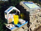 About a third of the way between the towns lies a village with an altogether different character. As we approached East Haven we came across a carefully tended help-yourself refreshments table collecting for a children's meals charity. Down on the beach was an even more surprising sign of a proud community: in the public convenience on the beach a vase of fresh flowers stood on a table beside the sink, and original works of art were hung on the walls outside the cubicles. The contrast between the utilitarian function of the building and the beauty of its presentation couldn't have been more striking.
Notes for future walkers:
- There's a well-signposted cycle path all the way from Carnoustie to Arbroath. Between Carnoustie and East Haven it's alongside the road inland of the railway. At East Haven it runs across the dunes on the estuary side of the line.
Tuesday, 1 September 2015
Greenbelt , Tech
Not seen at Greenbelt
We're back from Greenbelt. I'm delighted that it seemed to go rather well, considering the precarious financial position the organisation found itself in after last year's festival. Here's hoping it's fully back on its feet now.
 Here's one thing no-one saw at the festival: the Apple Watch Festival Guide. I'd hoped to include it in this year's iOS app, but time pressures meant it wasn't ready when I had to submit the app for review. I'm glad I didn't rush it. Although I had an app up and running at home last week, in the field it didn't work at all, showing just a blank screen. There's more work to be done here!