Sunday, 29 March 2015
Peddar's Way / Norfolk Coast Path
Stonebridge → Knettishall Heath
 Distance: 6.72 miles
Ascent: 88 metres
Duration: 1 hour 48 minutes
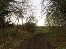
Road to Nowhere
« Not walked | Not walked »
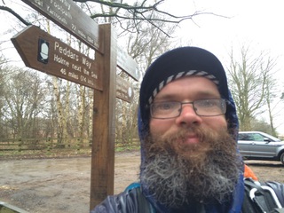
After a shade under seven miles in the rain I reached the end of the Peddars Way path! That's my fifth National Trail completed.
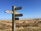
When I walked along the coast past the other end of Peddars Way I recounted the often-repeated suggestion that no-one knows Peddars Way's destination. They're usually referring to the coastal end, but one could say the same of the southern end. Peddars Way ends at a signpost on a road through a forest.
The finger pointing in the other direction reveals that perhaps this is just an interim destination. Ivinghoe Beacon and The Ridgeway National Trail is only 106 miles away. A path to follow on another occasion, perhaps.
But for now, my destination is due west. Thetford railway station is my gateway home. Just another five miles of rain and I'll be there.
Saturday, 28 March 2015
Peddar's Way / Norfolk Coast Path
Castle Acre → Stonebridge
 Distance: 21.76 miles
Ascent: 321 metres
Duration: 6 hours 5 minutes
Diverted by Churches
« Not walked | Not walked »
Today's walking wasn't as arrow-straight as yesterday's. The line of Peddars Way is lost in a number of places, so the route swings back and forth, all the while following the general direction of the Straight Line which it occasionally comes close enough to kiss.
I'd expected to walk fewer miles than yesterday, but three detours nudged my distance up. Each one was a diversion to look at a church. First, the ruins of Castle Acre Priory, which can be appreciated from the common land to its east. I didn't pay to go in, but a walk around the fence revealed the huge scale of the old complex.
 A tourist information sign by the side of the road promising "Historic Murals" diverted me half a mile to my second church: St Mary's, Houghton-on-the-Hill. Unfortunately the roadside sign hadn't revealed that the church is only open between 1200 and 1400 daily, so the best I could do was enjoy the tranquil setting and peer in through the heavily fortified windows. A notice outside revealed that the church has been lovingly restored over the years by "Bob", after finding the abandoned building being allegedly used by a group of satanists.
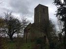
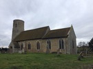 On the third occasion I was luckier. The round tower of All Saints, Threxton beckoned me off The Way, and a sign in the porch welcomingly declared "the door is never locked; stay as long as you like". Inside the pillars of the Nave leaned outwards like those in St David's cathedral. I couldn't help but kneel at the altar rail and pray.
Shortly afterwards I encountered the opposite sensation, and one that seems inevitable on any National Trail: a military firing range. The Way runs along the perimeter of the vast (120 km2) Stanford Training Area, a military site that in recent years seems to have been deliberately expanded rather than returned to the public. (It was first commandeered in 1942 at four weeks' notice; a petition to Parliament five years later requesting reinstatement apparently fell on deaf years.)
So another long walk, and thankfully the rain more-or-less held off. It's been a solitary day and I'm ready for a quiet evening in the pub at which I'm lodging. I think a part of me is still somewhere in those churches.
Friday, 27 March 2015
Peddar's Way / Norfolk Coast Path
Holme next the Sea → Castle Acre
 Distance: 20.35 miles
Ascent: 341 metres
Duration: 5 hours
The Roman Road
« Not walked | Not walked »
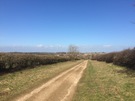
The ancient routes criss-cross our land. We know their names: Foss Way, Watling Street, Stane Street. Many have been upgraded over the years, layered with Tarmac and widened to dual carriageway. Pedlars Way is different. Seemingly going nowhere, the route serves no purpose to modern life so has been left abandoned, a farm track, a walking route, an echo of the past.
 Deer, partridge, pheasant, rabbit: I've collected the full set of wild animals today. And as the dunes of Holme receded and the arable fields turned to livestock I added pigs and horses to the list.
Walking such a long distance in so straight a line provides opportunity to appreciate how the landscape changes. It's a fallacy to claim that East Anglia is flat!
Castle Acre is the only village of any substance on Peddars Way, but even then it only supports one pub and a handful of B&Bs. "There used to be seven pubs," my host told me, "the last one to close was just a couple of years ago." It's a shame, but trade in the remaining Ostrich Inn tonight suggests there's community enough to keep it running. (Warning: the Inn's menu refers to their Toad in the Hole as having a "Giant Yorkie". They're not kidding; I could've used it as a hat, even for my humungous head!)
The castle itself is worth exploring; not much left by way of buildings, but hugely impressive earthworks and open all hours, for free! English Heritage also look after an old Priory here too, but it was closed when I arrived so other than reporting that the buildings look impressive from the road, I can't say much more about it.
Tomorrow's another 20 miler. The weather forecast doesn't look good. Wish me luck.
Saturday, 14 March 2015
The London Loop
West Wickham Common → Coulsdon South
 Distance: 15.71 miles
Ascent: 524 metres
Duration: 5 hours 9 minutes
Bromley, Croydon
« Not walked | Not walked »
The theme of this year's walking with be "finishing the job". Over the years we've started a number of National Trails and Recreational Paths and not completed them. By the end of 2015 I'd like them to be fewer in number.
First off the list is the London Outer Orbital Path — the M25 to the Capital Ring's North/South Circular.
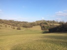 Today's leg was a beautifully rural hilly affair in cold and overcast weather. It's striking to realise that a day's walking in south London can require 75% of the ascent involved in climbing Snowdon from Pen-y-Pass!
We avoided the rain, and the clouds lifted sufficiently to reward us with a fascinating view north as we followed the spine of Farthing Downs, looking across the towers of Croydon to the familiar but distant London skyline hidden in the haze.
Saturday, 7 March 2015
Gig
The Unthanks

We're determined to see more live music this year. The plan was a gig a month; we failed to see anyone in February, but maybe it'll average out come December.
Tonight was The Unthanks, supported by The Young-Uns at The Roundhouse in Camden. All three have been on my to-do list for a while; the headline act since seeing their set at Greenbelt a couple of years ago, the support since missing them at Solas (I think they had to pull out at the last minute) and the venue since being aware of it when a student in London before its renaissance.

None disappointed. In fact, the combination was perfect. Folk songs from the north in the engine shed that still has the ghosts of the steam locomotives that used to haul trains there from the south.
Stirring, inspiring and rallying.