Friday, 26 September 2014
Saturday, 20 September 2014
Walks
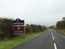
North Berwick Law
 Distance: 1.36 miles
Ascent: 149 metres
Duration: 39 minutes
Live for the Moment
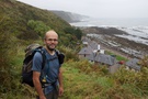
With the air suddenly clear we couldn't help ourselves: one last walk, one hill to climb as the sun set. It was the perfect decision.
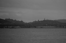
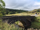
North Berwick Law isn't a particularly high hill, but like Iona's Dun I its isolation in an otherwise expansive plain provides stunning views.
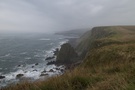
From the top we could see almost everywhere we've walked this week. To the east and south: the high cliffs of St Abb's Head, the nuclear power station at Torness, Barns Ness Lighthouse, Dunbar, Tantallon Castle, Bass Rock. To the west, Cockenzie power station, endless golf courses, Portabello and Leith. Other places we've come to know were visible too: the bulk of Arthur's Seat rising in Hollyrood Park, the latticework of the Forth Bridge. To the north we could make out Aberdour from where our coast walk will continue next year around the Kingdom of Fife.
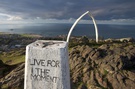
Painted on the triangulation pillar at the summit is the phrase "Live for the Moment". Indeed. If you have time to do just one walk in East Lothian, make it North Berwick Law.
Coastwalk
Aberlady → Leith
 Distance: 16.71 miles
Ascent: 69 metres
Duration: 5 hours 6 minutes
To the future
« Tyninghame | Queensferry »
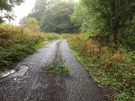
Today's walk has been slightly surreal. Almost dreamlike.
Some snapshots and two sketches:
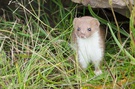 A weasel (or was it a stoat?) darting between two clusters of rock beside the path. He didn't stand still long enough for a good photograph.
A boat called "Mr Grumpy".
A disheveled man with a cigarette hanging limply from his mouth taking his monitor lizard for a walk.
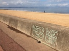 Graffiti along the sea wall, some tongue-in-cheek ("Cameron no more, Osborne no more, Darling no more, Clegg no more"), some providing detailed exposition of economic policies.
A treatise posted on a bus shelter that described why Devo-Max proponents should vote Yes instead of No.
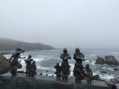
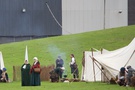 The sound of bagpipes drifted in the air was we passed Cockenzie power station. In the shadow of this behemoth Jacobite and Government troops gathered, ready to re-enact the Battle of Prestonpans, a key moment in the Uprising of 1745. The image is bursting with potential analogies: the referendum, the battle, the crumbling industrial past.
In 1994 I visited Portabello, Edinburgh's beach. On holiday by myself and about to graduate from university my head was full of possibility. I'd been reading about Windows programming and spent the evening looking at arcade games. I slept in the car and dreamt about my future. After telling Emma this story she said she'd have whispered into the ear of that 23 year old, "It's OK. Your life will work out."
So here we are. In Referendum Week we've walked from England to the seat of the Scottish Government. We've finished the 100th map of the walk so far and have less than 100 left to go.
We're feeling our way forwards into the future. Same as everyone.
Friday, 19 September 2014
Coastwalk
Tyninghame → Aberlady
 Distance: 17.06 miles
Ascent: 195 metres
Duration: 4 hours 59 minutes
The Golf Coast
« Cockburnspath | Leith »
The result is in: our island will remain one country, at least for the time being. We'd best keep walking.
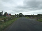
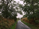
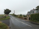
We're still not used to Scotland's Outdoor Access Code and consequently spent more time road walking today than we could have. From Tyninghame we trudged along the A198 all the way to North Berwick, missing out on enticing beaches (and also the potential trouble of walking around unfordable creeks!).
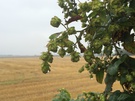 Then again, with more thick fog there wasn't much to see in the distance and our attention instead turned to our immediate surroundings: hops growing by the side of the road; freshly spawned toadstools beneath birch trees; a peaceful church; deep veins eroded into a sandstone pillar; a road sign pointing to North Berwick in one direction and (South) Berwick in the other.
 North Berwick itself is a delightful small town, with a High Street full of independent, artisan shops. Were it not for one thing I could quite imagine living here.
That one thing? Golf.
 Road signs declared the A198 to be "Scotland's Golf Coast Road" as if to confirm ownership of this area to the sport. We passed gates labelled "Private. Members and Authorised Key Holders Only" that seem to contradict the Access Code, signs designed to deter ("Walking on the course can be dangerous"). Even visiting golfers seemed to be second class citizens in Gullane where they are segregated into their own clubhouse.
With momentary exceptions, today's walk hasn't felt particularly welcoming.
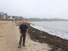
By the time we had finished and were on the bus back to Tyninghame the view had cleared somewhat. We saw the walls of Tantallon castle looking out to the Firth of the Forth with Bass Rock clearly visible, its surface completely covered in white dots of either birds or guano. Mirroring the rock inland, North Berwick Law rose above the town. It was difficult to appreciate that we'd been so close to such a dominant hill earlier but hadn't noticed it at all.
Thursday, 18 September 2014
Personal
A split decision
 Emma: Yes
Paul: No
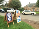
It seems we're as split as the nation. We'll be fascinated to see what the result is tomorrow morning.
One thing seems clear: which ever way the vote goes, there's an opportunity to build something new in Scotland, be it an independent country or a part of a refreshed federated union of nations. We're glad to be here north of the border for the week. We'd love to remain for longer and participate in helping the nation move forwards.
Coastwalk
Cockburnspath → Tyninghame
 Distance: 16.50 miles
Ascent: 186 metres
Duration: 5 hours 3 minutes
Familiar, forthcoming foreign?
« Eyemouth | Aberlady »
Just north of Cockburnspath the beautiful dell of the Dunglass Burn marks the boundary between the Scottish Borders and East Lothian. The Berwickshire Coastal Path ends here and is replaced by the John Muir Link, a relatively new waymarked path that links two coast-to-coast routes: the Southern Upland Way whose eastern terminus is Cockburnspath and the John Muir Way which ends in Dunbar. It'll be many years before we reach their western termini at Portpatrick and Helensburgh respectively.
 Once again the mist obscured the worst of man's sins on this stretch: Torness nuclear power station and Thorntonloch caravan park. (Here we saw a St George's Cross being flown high above a static van. It seemed dangerously out of place.)
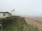
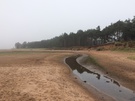 The high cliffs that we've been walking on for two days have ended, replaced with dunes and heathland reminiscent of East Anglia. It seems I'm not the only one to have made this connection: the sands of Belhaven Bay stood in for Suffolk in the BBC's recent film Castles in the Sky that recounted the development of radar.
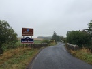
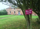 Being Referendum Day I was delighted that we ended outside a Polling Place, in the village of Tyninghame. By the time we start tomorrow we'll know whether in a couple of years' time we'll be walking in a foreign country.
Wednesday, 17 September 2014
Coastwalk
Eyemouth → Cockburnspath
 Distance: 17.16 miles
Ascent: 803 metres
Duration: 6 hours 1 minute
An appropriate metaphor
« The Border (Marshall Meadows) | Tyninghame »
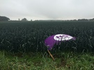
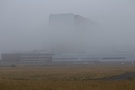
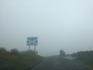
For much of today we were shrouded in mist. I wonder how many feel the same way about the referendum. The choice that has to be made is clear: Yes or No. The trouble is being able to see further than a short distance ahead; whichever way you look the way forwards is unclear. Walking through the thick mist and fog for a day was hard enough; it must be difficult to go to the polling stations tomorrow with the same lack of clarity.
This was always going to be the hardest walk of the week, and the weather didn't help.
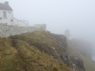 We tucked our heads down and just ploughed through it. So memories of St Abb's Head — which should be a highlight of the Berwickshire coast — are as limited as the visibility was. I suppose one positive outcome of the mist is that the extensive caravan parks at Hairy Ness and Pease Bay were obscured from view.
Sadly also obscured were the rock strata that have famous geological significance. We never did see Hutton's Unconformity, which surely is one of the most intriguingly named natural phenomena of the east coast.
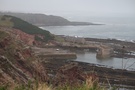 Eventually we found ourselves above the charming harbour at Cove. This sanctuary is reached by a steeply descending path that begins in Cockburnspath, running down the cliff and through a hand-cut tunnel to emerge at the back of the beach.
 The Berwickshire Coast Path is very well sign-posted, to the extent that only twice today could we not immediately identify the onward route. Despite the lack of a view we were able to recognise that this is a jewel of a coast path. If only we could've seen more!
Tuesday, 16 September 2014
Coastwalk
The Border (Marshall Meadows) → Eyemouth
 Distance: 7.49 miles
Ascent: 251 metres
Duration: 2 hours 46 minutes
A declaration of intent
« Berwick-upon-Tweed | Cockburnspath »
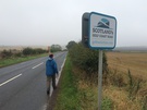
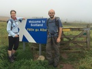
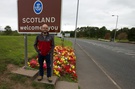
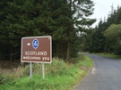
Of late many people have asked me the Scotland Question. This is the week I provide my answer: yes. Yes, we will be walking round Scotland too. (What do you mean, "there's another Scotland question"?)
 Today's short walk then was a declaration of intent; an opportunity to get the legs warmed up again after seven months off. This week of all weeks had to be the time to start walking round the North Country.
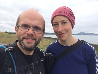
The sky was as grey as it was back in February as we posed for a photo on the border. Passing through the gate we said "goodbye" to the comfort blanket of England and Wales' Public Rights of Way and "hello" to the liberating Scottish Outdoor Access Code. Maps will no longer show green or red dotted lines for permitted routes; instead, pretty much all land can be walked across. It will be a while before we're used to this!
 "They've never quite got over the Disaster," was the description we were told of the people of Eyemouth — our destination for the day. Our reporter wasn't sure what the Disaster was, but pretty soon in Burnmouth a bronze sculpture of people scanning the horizon explained more. On 14 October 1881, communities along this coast were decimated when a storm took the lives of almost 200 fishermen and a significant percentage of the local fleet. Each of the villages that lost men has a similar sculpture.
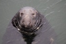 Eyemouth today remains a town focussed on its harbour. Seals swim freely amongst the boats, performing for the tourists who throw them scraps. Overlooking the harbour is the "House of Secrets". In its garden a TV news crew were making a film about the referendum. Behind them the lifeboat negotiated its way into harbour.
This boat is the focus of Eyemouth's biggest tourist event: the Herring Queen Festival. It provides the transport which brings the newly appointed Queen into the town, ladies-in-waiting at her side. The festival takes place in July, but pride in the event was still evident today with various houses around the town bedecked with plaques declaring them to be the place of residence of various key participants.
It's been a short walk, but a good welcome to the next stage of our coastal trek.
Monday, 15 September 2014
Places
Weaving a Union
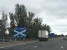
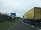
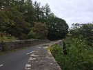
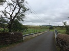
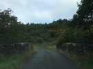
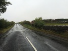
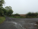
Today I drove from the west coast to the east. And as journeyed I zig-zagged back and forth across the Scottish border, placing a stitch in England and another in Scotland at each of the twenty-four places a public road crosses the border.
Here are the two dozen roads. Each photograph was taken in England looking towards Scotland.

Two thing were evident from today's trip.
First, the border is a stunningly beautiful place, even in today's drizzle. From Gretna where "No" campaigners have been constructing a "Hands across the Union" cairn to Lamberton where the A1 thunders across the invisible dividing line, this is a landscape I scarcely know.
My second observation is that after a few crossings I began to forget which side I was on. On occasions the English side of the border felt Scottish with tall pine forests while the gently sweeping pasture to the north felt English. The border line became invisible in places; at a few of the crossings it wasn't marked at all.
On Friday we'll discover whether or not this will become a new frontier. Either way, I'm inclined to start planning a walk that mirrors today's drive.
Side note:
The most unusual part of the journey was the twelve-mile unsurfaced Kielder Forest Drive. A lot of fun although a little nerve-racking in a Honda Jazz, particularly when I got to what appeared to be a roadblock manned by Gherkas on exercise.
Thursday, 11 September 2014
Extras
Sunderland Point
A frequent reaction when people learn of the Coastwalk is to ask me where the best bits have been. It's a difficult one to answer, but I do secretly harbour a list of places I'd like to revisit. Today I've ticked one of those off.
 I scarcely mentioned Sunderland Point on my write-up of the walk from Morecambe to Lancaster nine years ago. Although I only spent a couple of minutes walking through the cluster of cottages it left its mark on me and I've longed to return.
Ordinarily Sunderland Point is reached by a tidal causeway. The tide was in today so I instead parked a mile to the north-west at Potts Corner and walked along the edge of the salt-marsh to a track that leads to the village. Back in 2005 I'd cut across to the village on this track but today kept walking along the edge of the marsh.
 A little further south is Sambo's Grave where a "faithful negro" was buried in the 18th century, a sad and lonely place.
Eventually the land runs out and the Point is reached. After scrambling round its rocky end I dropped onto the beach and made for the houses.
I'm at a loss to describe the village; is it melancholic, beautiful or stoic? Perhaps all three. Cut off by the tide it was deserted, peaceful and enchanting.
Sunderland Point is by no means a tourist destination, but it's a place I'd recommend anyone visit. Go when the water is high. Walk from the north. Pay your respects to Sambo.