Thursday, 18 September 2014
Coastwalk
Cockburnspath → Tyninghame
 Distance: 16.50 miles
Ascent: 186 metres
Duration: 5 hours 3 minutes
Familiar, forthcoming foreign?
« Eyemouth | Aberlady »
Just north of Cockburnspath the beautiful dell of the Dunglass Burn marks the boundary between the Scottish Borders and East Lothian. The Berwickshire Coastal Path ends here and is replaced by the John Muir Link, a relatively new waymarked path that links two coast-to-coast routes: the Southern Upland Way whose eastern terminus is Cockburnspath and the John Muir Way which ends in Dunbar. It'll be many years before we reach their western termini at Portpatrick and Helensburgh respectively.
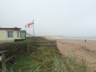
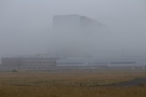 Once again the mist obscured the worst of man's sins on this stretch: Torness nuclear power station and Thorntonloch caravan park. (Here we saw a St George's Cross being flown high above a static van. It seemed dangerously out of place.)
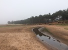 The high cliffs that we've been walking on for two days have ended, replaced with dunes and heathland reminiscent of East Anglia. It seems I'm not the only one to have made this connection: the sands of Belhaven Bay stood in for Suffolk in the BBC's recent film Castles in the Sky that recounted the development of radar.
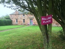 Being Referendum Day I was delighted that we ended outside a Polling Place, in the village of Tyninghame. By the time we start tomorrow we'll know whether in a couple of years' time we'll be walking in a foreign country.