Monday, 31 December 2018
West Sussex and the South Downs
In the Air
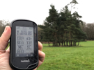
 Distance: 3.97 miles
Ascent: 210 metres
Duration: 1 hour 18 minutes
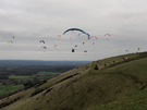
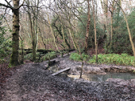
7. Devil's Dyke
I wasn't surprised to see paragliders throwing themselves into the air at Devil's Dyke, but the number of them on this cold winter day took my breath away, as did the stiff climb up from the village of Fulking. A lovely circular walk to end the day.
South Downs National Park and East Sussex
In the Opposite Direction
The next few walks will all feature part of the South Downs Way, which we walked back in 2010–2011.
![]() Distance: 10.06 miles
Distance: 10.06 miles
Ascent: 502 metres
Duration: 3 hours 1 minute
27. Ditching Beacon and Wolstonbury Hill
 Distance: 8.76 miles
Ascent: 295 metres
Duration: 2 hours 29 minutes
22. Blackcap and Stanmer Down from Ditching Beacon
I know Ditching Beacon very well; it used to be a favourite haunt when I lived with Mum and Dad. Nothing's changed in the direct vicinity, but the distant view is different now. Looking towards Brighton the i360 now dominates the town and in the Falmer direction the Brighton and Hove Albion's new stadium asserts itself rather too much amidst the download scenery.
Sunday, 30 December 2018
West Sussex and the South Downs
Beneath the Downs
 Distance: 10.76 miles
Ascent: 126 metres
Duration: 3 hours
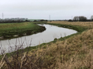
26. Bramber, Beeding and the Downs Link
Broadly following the line of the River Adur, this morning's walk felt almost East Anglian in character with wide flood plains and a broad horizon.
Saturday, 29 December 2018
West Sussex and the South Downs
Before the Sun Sets
 Distance: 5.79 miles
Ascent: 225 metres
Duration: 1 hour 54 minutes
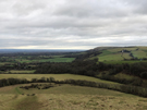
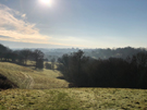
13. Wolstonbury from Hurspierpoint
Wolstonbury Hill is just east of where the A23 crosses the South Downs. It's a hill I've seen many times from the road but never climbed. The view from the top across the Weald towards the North downs is tremendous, but I didn't have time to linger today if I was to be down before sunset.
South Downs National Park and East Sussex
West to East
 Distance: 9.61 miles
Ascent: 222 metres
Duration: 3 hours 1 minute
24. Sussex Border Paths from Fletching
The Greenwich Meridian bisects Sussex, so on this walk close to the East/West Sussex border I crossed it a few times, and weaved around the Greenwich Meridian Trail, a relatively new long distance path which I'd love to walk one day.
Friday, 28 December 2018
West Sussex and the South Downs
Among the Bluebells
 Distance: 7.79 miles
Ascent: 290 metres
Duration: 2 hours 24 minutes
23. West Hoathly and Weir Wood Reservoir
 Distance: 4.99 miles
Ascent: 168 metres
Duration: 1 hour 35 minutes
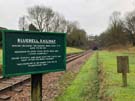
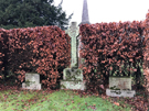
9. Horsted Keynes and the Bluebell Railway
 Distance: 4.92 miles
Ascent: 163 metres
Duration: 1 hour 35 minutes
10. Ardingly Reservoir
The Bluebell Railway is the theme that links these three walks. The heritage railway runs steam trains on a line stretching from East Grinstead near the first walk through Horstead Keynes on the second. That's where you'll also find the grave of Harold Macmillan. While I heard the trains today, I didn't actually see them. Perhaps it's not the best time of year for bluebells.
Thursday, 27 December 2018
West Sussex and the South Downs
Close to home
While we're staying in Sussex a while I've picked up the two local books of walks in the Pathfinder Guides series. Each has twenty-eight walks. My challenge is to complete as many as possible before we move on. The write-ups will be brief.
 Distance: 5.35 miles
Ascent: 193 metres
Duration: 1 hour 39 minutes
12. Cuckfield and Ansty
Let's start with the walk that's only a mile away from home. I know some of these paths, and I really dislike them. Mud: that's the defining characteristic, at any time of year. Not the best introduction to Sussex.
Friday, 14 December 2018
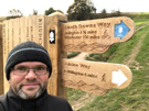
South Downs Way
Alfriston → Eastbourne (Bridleway)
 Distance: 7.97 miles
Ascent: 396 metres
Duration: 2 hours
An epilogue
« Not walked | Not walked »
Between the village of Alfriston and its eastern terminus in Eastbourne the South Downs Way has two alternative routes. The most popular — and the one we walked in 2010 is a footpath over Beachy Head and the Severn Sisters. Since horse riders and cyclists aren't permitted on that route, an alternative bridleway follows the northern edge of the Downs escarpment; that's the route I've followed today.
So as a birthday treat to myself I'm back on a National Trail.
There are essentially just two climbs on this route, with the village of Jevington at the halfway point providing a break between them. (Fun fact: Jevington is the birthplace of Banoffi Pie.)
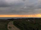
I started the first ascent — Windover Hill — just before dawn, and had the downland to myself save for a solitary horse rider. By the time I reached Eastbourne, the dog walkers were out in force, and the sun had begun to warm the mist.
 I had considered returning on the footpath across the chalk cliffs. But although it's been a good morning to be out, it's too cold to turn this into a circular walk. I took the bus back to the village.