Friday, 28 September 2018
Hadrian's Wall Path
Carlisle → Bowness-on-Solway
 Distance: 15.54 miles
Ascent: 170 metres
Duration: 5 hours 30 minutes
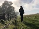
The salt marsh
« Gretna | Not walked »
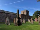 Hadrian's Wall Path follows the coastline for most of its length west of Carlisle, so I've walked much of today's leg before. After following the River Eden through Grinsdale, Kirkandrews-on-Eden and Beaumont, the path finds itself at Burgh by Sands where the church contains fragments of decorative Roman masonry built into its interior, and a plaque commemorates the first recorded African community in Britain, a cohort of Ethiopian soldiers who guarded a local fort.
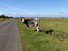 We were soon on the course of the Wall again, walking the long, straight road over the tidal Burgh Marsh. An 8.9 metre tide was scheduled for the afternoon, almost guaranteed to flood the road, so although it was tempting to linger and admire the expansive view we hurried on to the safety of Drumburgh at the western end of the causeway.
Stopping briefly at the Post Carlisle photo opportunity, we followed the end of the Wall Path along the narrow road to Bowness on Solway. The views here were spectacular: the Scottish lowlands to the north and shimmering reflections of clouds above the Solway Firth.
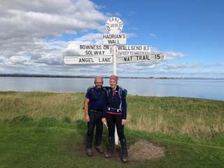
The official end of the Path comes as a slight surprise: a small wooden shelter stands over a mosaic floor, decorated with pictures of the many wading birds that accompany the finals stage of the route along the Firth. Although this walk has been all about military engineering, it's as much about how humans have adapted to, and worked with, the huge natural landscape.