Sunday, 15 July 2018
Pennine Bridleway
Birch Vale → Diggle
 Distance: 21.23 miles
Ascent: 956 metres
Duration: 7 hours 4 minutes
Fire
« Not walked | Not walked »
My original intent had been to walk these four sections of the Pennine Bridleway a fortnight ago, but I put that plan on hold when a week earlier news broke of a wild fire raging on Saddleworth Moor. Today's leg traced the edge of the fire ground.
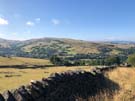
 Before getting there, I took the "non-bridleway" section of the bridleway. Being a new National Trail, the route isn't yet fully established, and for a section between Cown Edge and Lees Hill there isn't yet a path with bridleway access. Horses and cyclists take to the roads while I followed the "interim" walkers' route. This alternative route followed the sharp line of Coombes Edge, curving high above Charlesworth for a delightful mile or so, but the section wasn't well signposted at all, so I was glad to have checked the line of the path on the National Trails website before setting out. (On the positive side, the route took me past a couple of tremendously-dressed wells just before leaving Derbyshire.)
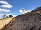 Higher Swineshaw Reservoir provided an excellent point from which to view the fire damaged moors. Framed by the water and the deep blue sky, the blackened land took on an unusually beautiful hue, but after walking a few miles along the Moor Edge Road, with burned heather to the right and luscious pasture to the left the extent of the destruction was clear. Despite that, it was pleasing to see tiny flecks of green amongst the charred earth. It could have been source material for a parable about never being too late to start again.
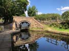 Eventually leaving the moor, the path dropped to follow yet another disused railway line (they seem to be a feature of the Bridleway) along the Tame valley to the village of Diggle, the southern end of the Standedge canal and railway tunnels under the main Pennine ridge, whose ventilation shafts we saw last year on from the Pennine Way walk.
Notes for future walkers:
- The walkers' alternative is poorly signposted. Check the route before you set out.
- I lost sight of the path on both sides of the A626 Glossop Road north of Charlesworth. Approaching the road from the east I couldn't find the path heading north from SK 010 936, and after crossing the road I ended up on the wrong side of the fence at SK 007 938. This latter mistake seems to be down to a poorly-signed recent re-routing of the path.
- The route at SK 001 947 (The Hague) looks impassable due to an imposing iron gate. There's a similarly huge kissing gate hiding to the left.
- The worst-maintained footbridge I've ever seen is at SK 007 976 in Swallow's Wood Nature Reserve. Thankfully the water level was low and I was able to find an alternative route round the precarious structure.