Tuesday, 2 May 2017
Coastwalk
Wick → Keiss
 Distance: 11.80 miles
Ascent: 173 metres
Duration: 4 hours 10 minutes
Castles and beaches
« Lybster | John o' Groats »
 At last, we've left the main roads! It's a little too far for us to reach the end of the east coast today so we split the remaining distance at the hamlet of Keiss which is well-served by the John o' Groats to Wick bus.
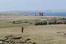
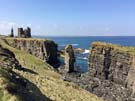 The walk was of two halves: first a clifftop amble past the lighthouse and castles on the Noss headland, followed by a four mile walk along the sands of Sinclair's Bay.
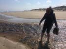 About one third of the way along the bay, the Burn of Lyth empties into the North Sea. The books we'd read suggested that this was a potentially deep and treacherous river, but we found we could cross it with little difficulty.
Just after the Burn an arrow-straight railway runs inland, perpendicular to the beach, for five miles. Pipeline packages are constructed on the railway and then dragged out to sea. One imagines this may present a more difficult obstacle to cross from time to time, but there was activity today.
Notes for future walkers:
- There's a good signposted path around North Head in Wick from ND 336 950.
- We stayed on the minor road through Papigoe and Staxigoe to Field of Noss Farm.
- From the farm, a good path leads via Noss Head and Castle Sinclair Girnigoe to Ackergill Tower (ND 352 547) where we joined the shore.
- We had no problem wading across the River of Wester on the beach (ND 340 576).