Wednesday, 15 March 2017
Offa's Dyke Path
Kington → Knighton
 Distance: 14.36 miles
Ascent: 822 metres
Duration: 4 hours 53 minutes
The Dyke
« Not walked | Not walked »
A transposition of two letters, and the addition of one more, separate the start and end of today's walk. This is deeply satisfying to me. Two things made the day even more satisfying: glorious blue skies and the return of the Dyke.
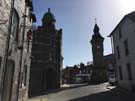 Knighton is the spiritual home of Offa's Dyke Path. It's approximately half way along the National Trail, was where the Path was launched back in 1971, and the town's Welsh name - Tref-y-clawdd - literally means "town on the dyke". There's a visitor centre here that sketches out the Dyke's history, but essentially all that's certain is that it is historically attributed to the 8th century king Offa and that it broadly approximates the England/Wales border.
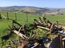
Perhaps one third of the length remains visible on the ground: a raised embankment with an adjoining ditch on the Welsh side. Photographs don't do the enormity of the engineering task justice; this 200-mile earthwork must have required massive effort to construct and maintain, to the extent that it's still evident 1,250 years later.
The longest continual stretch lies either side of Knighton, making the walk from Kington an absolute joy - particularly in glorious weather. In fact, on three occasions I was so distracted by my enjoyment of the walk that I missed turnings and gates I was supposed to take.
Sadly, although I will continue to walk on the Dyke itself tomorrow, I suspect the stunning weather won't hold.