Thursday, 16 March 2017
Offa's Dyke Path
Knighton → Mellington
 Distance: 15.47 miles
Ascent: 1227 metres
Duration: 6 hours 17 minutes
Halfway
« Not walked | Not walked »
The last time I set out from Knighton I was heading for Welshpool on Glyndŵr's Way. I'll be there again in two days' time, rather than the eight days it took me last year.
Today's walk is said to be the toughest of the entire Path. Pah! It's not that fearsome if you're used to coast walking or have recently completed the longer route to Welshpool.
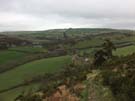
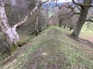 Today's walk was remarkable. Once again the Dyke was present for most of the route, but this time I somehow felt more connected to it. I've learned to read the landscape and can pick out the Dyke in the distance. It's the thing that looks like a field boundary - a line of trees or a hedgerow - but a boundary that is uninterrupted by roads and rivers. It just keeps marching over the landscape in the same direction, paying no heed to topography.
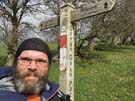 Also of note on the route is the halfway point of the entire Path. I'm now nearer Prestatyn than Chepstow, and I'm finally allowing myself to believe that I'll complete the whole thing in this one trip. (But I've still another six days' walking to get there.)
Notes for future walkers:
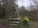 In 1971 a stone was unveiled in Knighton to commemorate the official opening of Offa's Dyke Path. Bizarrely, it isn't on the route; if you want to see it, hop west across the dyke between the Offa's Dyke Centre and the River Teme.