Saturday, 25 June 2016
Glyndŵr's Way
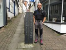
Knighton → Felindre
 Distance: 15.65 miles
Ascent: 847 metres
Duration: 4 hours 49 minutes
Up and down
« Not walked | Not walked »
Having a week's holiday without Emma is a new thing for me, as is the alternative: Mum's come instead! She'll be chauffeur/support while I walk Glyndŵr's Way, Wales' most recently created National Trail. The Way joins two points on Offa's Dyke — Knighton and Welshpool — by way of a long detour to Machynlleth on the Dyfi estuary.
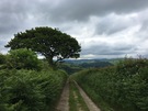 Mid-Wales remains undiscovered territory for me, and an area that I remember Dad recommending. This week I hope to get a feel for these valleys and hills.
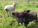 Today's been very much about getting used to the landscape. Once Knighton is left behind, the route heads for the hills, crosses grazings and follows farm tracks down to the village of Llangunllo in the adjacent Lugg Valley. Then it's back up again, across the moor to return to the Teme Valley ten miles upstream from the start.
![]() The weather has been up and down too, with equal measures of glorious sunshine and cold, penetrating showers. Looking at the forecast I think this is likely to be the measure of the week ahead.
The weather has been up and down too, with equal measures of glorious sunshine and cold, penetrating showers. Looking at the forecast I think this is likely to be the measure of the week ahead.
Notes for future walkers:
- Since this is a National Trail, route-finding has been relatively easy: just follow the acorn signposts.
- Having said that, it could be better signed Cefn-suran. The route leaves the farmyard by a path through a copse, too small to appear on the map.
- At SO 206 726 keep an eye out for a gate off the track on the left before the big barns: the route continues through the gate rather than ahead by the pond.