Thursday, 24 September 2015
Coastwalk
Muchalls → Aberdeen
 Distance: 15.41 miles
Ascent: 397 metres
Duration: 5 hours 16 minutes
Granite City
« Inverbervie | Bridge of Don »
Aberdeen is our target for this year's walking, so we're delighted to have reached Granite City with a few days left in the week.
The city simultaneously impressed and disappointed, much as the whole of today's walk has.
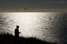
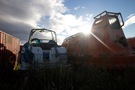 Thick cloud foiled this morning's attempt to watch the sun rise over the North Sea, so our early start was in vain. This was no bad thing though: there was nowhere on the early part of the walk that gave a suitable vantage point to the east. Instead we found ourselves alternating between farm track and roads until we finally reached the boundary between Aberdeenshire and the City of Aberdeen. Almost surreal was the moment we found ourselves amongst hundreds of life vessels that were being serviced before redeployment on rigs at sea.
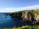 At this point (Cove Bay) a good quality coast path began. Clearly the City council's attitude towards coast walkers is more welcoming than the county council's. (Or is it just that they have only ten miles of coastline while the county has more than ten times that distance?)
The path wound its way past the comically-horned animals of a rare breeds farm and finally reached the open sweep of Nigg Bay. On the map this looked charming: soft sand, obligatory disused church, and a lighthouse at the far side. In reality it was messy and smelly, with a refuse tip and industrial works dominating one end.
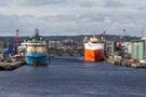 The lighthouse marked the start of Aberdeen Docks and as we turned the corner the city revealed itself. Or rather, it would have except that it seemed to be hiding behind huge ships and dock buildings.
What about the granite? We certainly saw plenty — every building here seems to be made of it, from the lowliest bungalow to the grandest of civic centres. (One wonders whether affluent locals are proud of brick kitchen work surfaces the way granite is prized in the south!) But as interesting as the uniform material is, it lends everything a dull greyness as if the whole town is weeping.
I won't let that be my lasting memory of the city though. Instead, let me remember the fingerpost sign I saw by the docks: "Ferry to Northern Isles"; we really are a long way north.
Notes for future walkers:
- A good track north from Muchalls via Mains of Monduff leads to Newtonhill.
- Cross the railway in Newtonhill and follow Skateraw Road to its end where a path to the left runs down to the bridge at the back of Newtonhill Bay.
- Cross the bridge and continue in the same direction up a steep path to join the track that contours around Cran Hill at NO 916 938.
- Farm tracks lead on from NO 918 944 to cross the Burn of Daff (NO 920 946) and reach Downies (NO 923 951), then from NO 925 950 through NO 928 960, NO 929 959 to Porthlethen Village (NO 930 962).
- From the end of the road in Porthlethen (NO 935 963) we followed field-edge paths to the life-vessel refitter (NO 936 969).
- Through Findon and Cove Bay we were back on roads: NO 937 973, NO 938 974, NO 938 977, NO 939 984, NJ 939 002, NJ 952 008, NJ 952 013 to NJ 953 015.
- At NJ 953 015 a good path runs back to the clifftops and then north all the way to Nigg Bay. (A signpost suggests that this path might in fact begin further south at Cove Bay Harbour.)
- We stayed beneath the road around Girdle Ness most of the way to the breakwater, but felt that the road would've been a better choice.