Tuesday, 22 September 2015
Coastwalk
Montrose → Inverbervie
 Distance: 18.80 miles
Ascent: 242 metres
Duration: 6 hours
A tale of two counties
« Braehead of Lunan | Muchalls »
One third of the way through today's walk we finished the Angus Coastal Trail and started on Aberdeenshire. Angus benefits from a published guide book, but the best Aberdeenshire can rustle up is the promise of work yet to come. I suspect the council priorities are elsewhere right now.
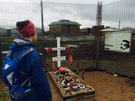 We'd get to Aberdeenshire in good time, but first we had to leave Montrose. On the quayside there's a huge statue of a dog. Bamse seems to have become a local hero during the second world war, and his statue certainly supports that, but his grave is tucked away in sand by the corner of a high security fence. It's a curious sight, as if the council don't quite know what to do with it.
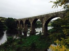
 Our remaining time in Angus was along the wide sands of Montrose Bay, eventually cutting inland past a derelict bothy to a pair of beautiful viaducts that led us into Aberdeenshire.
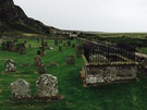 Abandoned churchyards seem to be a regular feature of the east coast of Scotland. Today's was beneath the village of St Cyrus and in the dank air its isolation and sorrow were very potent.
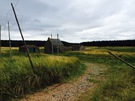
Overgrown paths and muddy fields with no exits slowed us down so we were pleased when we finally found the cycle path that runs through a few of the coastal communities here. If today's route-finding is anything to go by, Aberdeenshire will be a challenge.
Notes for future walkers:
- The way to the shore on the River North Esk is relatively easy to find — follow the signs to Bamse's grave.
- At high tide the beach is impassable alongside Traill Drive but the road provides a quiet alternative. Drop onto the sand where the road bears inland at NO 727 582.
- We left the beach at NO 738 617; there's an abandoned farmstead here just behind an obvious gap in the dunes. We then followed the track west north-west to the edge of the plantation at NO 734 618, then north — staying outside of the trees — until meeting the river. Running west from NO 734 621 a track, then a narrow path, follows the river to the viaducts of Lower North Water Bridge.
- Cross the old railway viaduct, then circle down left to the road running to the visitor centre at Cocklem Bents.
- We left the track that runs at the foot of the Heughs of St Cyrus by the zig-zag path that climbs from NO 753 646, although there appears to be another exit from the beach further to the north that meets the clifftops at Woodston Fishery (NO 756 649).
- We failed to find a way across the Woodston Burn gully and ended up rejoining the road through Nether Woodston to the A92.
- Rejoin the coast at Tangleha' Cottages (NO 771 650) by taking the road that leaves the A92 at NO 759 657.
- Between Tangleha' and Milton of Mathers, follow the foreshore initially but keep an eye out for a path that eventually becomes distinct at the back of the beach.
- Beyond Milton of Mathers a decent coast path and eventually cycle path leads the rest of the way to Inverbervie.