Sunday, 20 September 2015
Coastwalk
Arbroath → Braehead of Lunan
 Distance: 13.08 miles
Ascent: 299 metres
Duration: 4 hours 19 minutes
Smokie
« Carnoustie | Montrose »
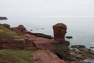 The first six miles of this walk are very popular. North of Arbroath the red sandstone cliffs have eroded into stunning stacks, arches, caves and blowholes. Angus Council publish an excellent Geodiversity Trail leaflet describing the route and its geology in great detail. A highlight for us involved a diversion for 100m or so into a field to Gaylet Pot - a deep hole where the roof of a cave has collapsed and from which emanated the sound of unseen waves, a long way below.
The smokie shops of Arbroath weren't open as we set off. It's said that the smokie actually originated in Auchmithie, the village at the northern end of the Geodiversity Trail, but that its technique was taken south to Arbroath in a mini economic migration.
 Beyond Auchmithie we were on farm tracks and fieldside paths past Red Head and Ethie Haven before dropping down to the sands of Lunan Bay at Corbie Knowe. A couple passed us asking whether the route they were on would take them to Auchmithie. As locals they'd been exploring the coastline themselves over the years and it seemed clear to me that walking in Scotland will take the form of exploration more than following a path.
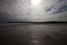
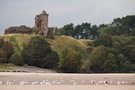 Lunan Bay is expansive and well known, but quite quiet at the southern end. Towering above the beach to the west is the ruin of Red Castle, guarding the mouth of the Lunan Water which we splashed across to reach the more popular northern end of the beach. Crossing the dunes to the car park we picked up a path across scrubland and up the hill to Braehead of Lunan, a village clustered around an obelisk whose import we didn't stop to discover.
Back in Arbroath to collect the car we were early enough to look round the ruins of the abbey, which was a real delight. The resonant acoustics of the sacristry were worth the admission alone.
Walk complete, abbey visited, there was only one thing left to do: finally buy a smokie. It's an ugly thing — like something you'd dig out of a bog, with its leathery-looking, oak-tanned skin — but it tasted delicious. I guess I was wrong yesterday.
Notes for future walkers:
- Be sure to pick up a copy of the Geodiversity Trail leaflet for the Arbroath to Auchmitihie section.
- We followed the village road in Auchmithie, then the farm track / green lane to Red Head: NO 682 445, NO 679 448, NO685453, NO 684 456, NO 693 463, NO 692 466, NO 702 473.
- At NO 692 446 the Angus Coastal Path signs pointed north north-west towards Ethie Barns but we turned right towards Red Head.
- Where the farm track meets the cliffs by an abandoned compound at NO 702 473, we picked up a field boundary path north past the trig point, diagonally across a stone wall junction and on to East Comb and the dam above Kirk Loch.
- From Kirk Loch (NO 704 479) we continued along the field edge north then west until NO 697 488, when we found a gap in the hedge that let us drop north onto the access track for Ethie Haven.
- Lunan Bay beach provided easy walking; on the beach the Lunan Water was not quite ankle deep.
- From Lunan Bay car park (NO 691 515) take the track running north behind the dunes. Keep an eye out for the path that rises on the left with the land to the west; it'll drop you onto a clifftop track at NO 693 522 that runs north-west under the railway viaduct to the road junction in Braehead of Lunan at NO 690 527.