Monday, 24 February 2014
Thursday, 20 February 2014
Wednesday, 19 February 2014
Saturday, 15 February 2014
Coastwalk
Berwick-upon-Tweed → The Border (Marshall Meadows)
 Distance: 5.17 miles
Ascent: 163 metres
Duration: 1 hour 58 minutes
Fàilte gu Alba
« Holy Island Causeway | Eyemouth »
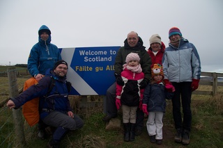
We did it!
Just under fifteen years after starting to walk the coastline of our island, and a little over two years since we finished walking the Welsh coast we've now completed the second of the three countries that make up this land. England is done; just Scotland to go!
 Better still, we had company: Mum joined us for the full distance from Berwick, and my brother Jez brought his family for the last mile to the border.
All week it's been anyone's guess as to whether the weather would co-operate today. In the end it wasn't bad: a little light drizzle, but by the time we all met up there was the faintest hint of sun.
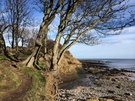
 The path from Berwick is relatively straightforward, though incredibly slippery after recent rain. At Marshall Meadows things improve considerably, with a tarmac road through the caravan site, then a well tended path to the border.
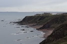
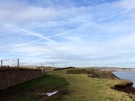
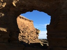
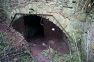 It's worth pausing at Marshall Meadows. Hidden between a couple of caravans at NT 982 567 is a hollow with an ominous "Enter at own risk" sign. If you pass through the gap in the fence and scramble to the base of the hollow you'll find a stone retaining wall, then a stone arch beyond which is a steeply inclined tunnel that eventually emerges halfway up the cliff. From further to the north the cliff entrance can be seen: it's what looks like a trapezium-shaped cave above a rickety-looking staircase. Quite what this tunnel was originally built for I don't know, but it no doubt provides thrilling access to the beach for holidaymakers.
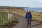
Beyond the caravans, we caught sight of a tantalising flash of blue and white: the border. It's marked by a kissing gate onto which is affixed a stylised Saltire sign of the type that appears on road border crossings. We crossed and walked inland to the railway line where a more ornate sign is erected for the benefit of passengers.
It doesn't matter how you measure this walk so far — the three hundred and twenty-one write-ups, the fifteen years, the three thousand four hundred and sixty-seven miles, the four pairs of boots, the ninety-six maps — however measured I've had a wonderful time and can honestly say I've enjoyed every single walk (yes, even the Black Path).
What next? Do you really need to ask? Fàilte gu Alba: Welcome to Scotland.
Monday, 10 February 2014
Coastwalk
Holy Island Causeway → Berwick-upon-Tweed
 Distance: 10.32 miles
Ascent: 108 metres
Duration: 3 hours 26 minutes
The last map in England
« Bamburgh | The Border (Marshall Meadows) »
 Explorer Map 346 is the most northerly in England. Today it became the last map of the English coastline that we've not completed. We're nearly done!
 Our original plans had us including a circuit of Holy Island in the coast walk, but tides and lack of out-of-season bus services caused us to rethink. Consequently we had a shorter walk than expected today, and it's been the best walk of the week so far.
 Two thirds of the way along the walk we passed within metres of the cottage where we've been staying, but decided that rather than stop we'd continue going until we'd crossed the River Tweed.
Berwick soon came into view, defended from the river by towering ramparts. It looked formidable from the southern side of the river, the town's history of switching back and forth between Scottish, English and independent affiliation ever so believable.
 Above our heads, two jet contrails crossed to form a perfect Saltire in the sky. It felt appropriate somehow.
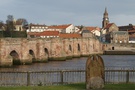 Crossing the river on the Old Bridge felt like a crossing a threshold. This was the border once upon a time after all.
We have a few days off now: we'll be joined by family on Saturday for the final walk although with the end in sight it's tempting to just get out again tomorrow before the weather turns for the worse again.
Sunday, 9 February 2014
Coastwalk
Bamburgh → Holy Island Causeway
 Distance: 13.30 miles
Ascent: 270 metres
Duration: 4 hours 9 minutes
Not the Northumberland Coast Path
« Craster | Berwick-upon-Tweed »
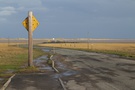
 For most of the way between Bamburgh and the causeway to Holy Island there are no coastal footpaths. The Northumberland Coast Path resolves this by heading about three miles inland.
 We ended up walking many miles on minor roads, crossed the mainline railway twice, and took to the verge of the A1 for half a mile. With an ever-present threat of rain, a howling wind and biting cold it wasn't the best of days.
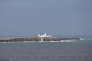
 Just north-west of Bamburgh, at Blackrocks Point where there's a white stag painted on the rocks, we saw a couple of groups of people with telephoto lenses trained on the sea. We stopped and looked, then excitedly nodded as we saw twenty or so seals swimming close to the lighthouse. It's a good job we didn't enter into conversation with our friends: after examining at the photographs we took we see now that all of the "seals" were in fact ducks.
Notes for future walkers:
 Diverge from the Coast Path at NU 161 358: instead of turning south on the footpath, continue south-west on the bridleway to Heather Cottages, then turn right on the footpath from the phone box at NU 160 356 to Budle.
- Follow the road west from Budle to Waren Mill, then Easington, Easington Grange and Elwick.
- At NU 100 377 take the bridleway north then north-west to Fenham-le-Moor, then turn south-west on the road over the railway at Lowmoor Crossing to the A1 just south of Buckton.
 Follow north-west to NU 082 386 where a poorly-signed footpath runs north to Fenwick Stead, crossing the railway before reaching Fenham.
- From Fenham, pick up the footpath towards Granary point; after turning west-north-west and crossing scrubland this eventually rejoins the Northumberland Coast Path about half a mile shy of the Holy Island causeway at NU 078 419.
Saturday, 8 February 2014
Coastwalk
Craster → Bamburgh
 Distance: 14.21 miles
Ascent: 285 metres
Duration: 4 hours 44 minutes
Castle to Castle
« Alnmouth | Holy Island Causeway »
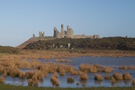
 A mile or so north of Craster is Dunstanburgh Castle. Its toothy form has been visible on the horizon for a few walks now, so we were pleased to see it close-up at last. Its scale intimidates, even in its ruinous state. Feeling pushed for time we decided to postpone looking around inside but this is definitely somewhere to revisit.
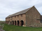
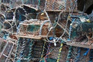 It would be easy to omit walking down to the harbour at Beadnell, but we strongly recommend you take time to visit it. This tiny haven is backed by large lime kilns which were stacked high with lobster pots, providing an atmospheric (and sheltered) lunch spot.
 Between Beadnell and Seahouses we walked on the beach, crossing an ankle-deep stream at the northern end before climbing up to the golf course on North Sunderland Point.
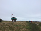
 To the east the Farne Islands lay low on the horizon all day. Even now, in early February, one kiosk in Seahouses was selling tickets for a boat tour of the rocks but the biting wind and choppy seas deemed the prospect highly unlikely.
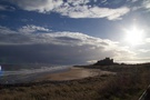
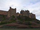 Between Seahouses and Bamburgh the Northumberland Coast Path's official route runs about half a mile inland from the shore but we stayed on the sands. It was easy walking with only one minor challenge: clambering up and across the sand dunes beneath the impressive Bamburgh Castle.
Friday, 7 February 2014
Coastwalk
Alnmouth → Craster
 Distance: 7.85 miles
Ascent: 172 metres
Duration: 2 hours 47 minutes
Northumberland in miniature
« Warkworth | Bamburgh »
 The final push begins here. We're back on the coast, with a short week of walking ahead, hopefully culminating with the completion of England's coastline next Saturday. With only fifty miles or so to go, can anything go wrong now?
 The weather looks set to do its best to trip us up. A series of heavy storms have battered the country since late December, and they've not let up yet. That being said, we've had a remarkably dry day today, enabling us to complete this short warm-up walk as a prelude to the rest of the week.
 It's been a bit of a "nothing" walk really. As ever it's good to be back on the trail, but nothing really stands out as a feature.
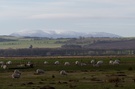
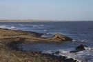
 On the other hand, one might consider this walk to be very representative of Northumberland's coastline: the odd golf course and caravan site interspersed with sandy beaches and secluded coves (Iron Scars near Howick was particularly beautiful).
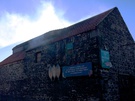 At Craster our nostrils were filled with a sweet scent reminiscent of pancakes and maple syrup. In fact it was Robson & Sons' Smokehouse, where kippers are a speciality. Clouds of smoke billowed out of the shutters at the top of the building, meaning a purchase was inevitable, even though we plumped for salmon rather than the classic kippers.
Monday, 3 February 2014
Coastwalk
Middlesbrough → Port Clarence
 Distance: 6.06 miles
Ascent: 118 metres
Duration: 2 hours 18 minutes
The Tees
« Marske-by-the-Sea | North Sands, Hartlepool »
There was a gap. This needed rectifying. I could've chosen to brush it under the carpet, claim that it doesn't count. But under my rules that would've been cheating. And before this month is out I want to be able to look you in the eye and say I've walked England's entire coastline, so I had to head north today.
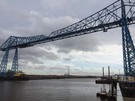
Back in September we'd hoped to walk from Middlesbrough to Hartlepool, starting with a flight across the iconic Tees Transporter Bridge. En route we discovered that the bridge had closed just a few days before, for four weeks' painting. "Never mind," I thought, "we can slot that bit in on our way up to Northumberland in the New Year." In December the local council (who operate the bridge) finally admitted that four weeks was a little optimistic, and the bridge would finally re-open late in the Spring.
So today I've travelled all day to walk upstream to the next bridge, in order to complete a walk that finished just a few hundred metres across the water from its start.
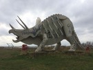 A short distance upstream from the Transporter on the south bank is Teesosaurus Park: an area of open land which has been visited by large steel dinosaur figures. It seems fitting: this area used to be packed with ironworks, but they're all gone now, leaving only occasional relics such as the bridges.
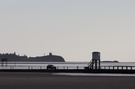
 The Transporter isn't Middlesbrough's only curious bridge. I crossed the Tees on the Newport Bridge, an iron girder design whose entire central span could be lifted high into the air by counterweights dangling from huge chains and cables to let ships pass. Its lifting mechanism has been retired now, leaving another iron fossil with its feet in the river.
 The north bank is full of industry. Mainly chemical works now, but it's still possible to see the silted up docks where ships were once built. They construct offshore wind turbines here now: dinosaurs of the future maybe.
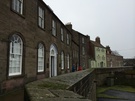
 Towards the end of the walk I reached residential streets again. High Clarence and Port Clarence have suffered badly. The first row of houses I saw had a v-shaped gap where two had been burnt out recently. Every terrace had at least one boarded up property, and on one street every house was shuttered. Houses here are auctioned with incredibly low starting prices: less than £10,000 at times. With industry largely absent, and the main link to Middlesbrough being the unreliable Transporter it's perhaps no surprise.
 I'm no longer shocked at the sight of horses abandoned on the verges, and grimy, derelict land. These things aren't representative of the North-East, but I've come to expect them. This last year walking up from Skegness has shown me a face of England that I'd never known before.