Monday, 7 October 2013
Coastwalk
Highbridge → Bridgwater
 Distance: 12.79 miles
Ascent: 26 metres
Duration: 4 hours 16 minutes
The Parrett
« Weston-super-Mare | Combwich »
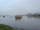
Six miles west of Highbridge stands Hinkley Point power station. The regular square blocks stood out when we first saw them towards the end of yesterday's walk. They may only be six miles away, but it'll take us a couple of days to get there, chiefly because of the main feature of today's walk: the River Parrett.
We turned our back on the sea almost as soon as we'd started walking today, heading upstream from the river mouth to its first crossing point in Bridgwater.
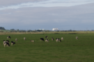
The Parrett meanders slowly across the Somerset Levels in long, sweeping bends. The path sticks firmly to the river embankment, with only the grazing sheep and cattle for company.
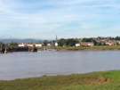 We've had mixed weather today: a misty start and a drizzly end contrasted with a few moments of sunshine as we passed the village of Combwich on the opposite bank.
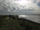
Judging by the large number of padlocked and otherwise unfriendly field gates, we surmise that this path isn't trod very often. It's no surprise given in places the river turned us through 180 degree loops, playing havoc with our sense of direction.
 The importance of fixed point of reference as a navigational aid became abundantly clear. Pawlett church tower is whitewashed, presumably to facilitate in this manner; the scale of the power station means that it unintentionally provides a similar service. At Dunball Wharf we were forced off the river bank, having to continue most of the way into Bridgwater on the A38, although a short distance
Notes for future walkers:
- From Dunball Wharf (ST 310 408) we had to follow the A38 south towards Bridgwater. The cycle path on the river bank shown on our map didn't exist on the ground.
- Keep an eye out for a tiny footpath running west from ST 307 387 that takes you back to the river; it's squeezed between two houses and could easily be missed.