Wednesday, 9 October 2013
Coastwalk
Combwich → West Quantoxhead
 Distance: 18.32 miles
Ascent: 5:44 metres
Duration:
The future coast path
« Bridgwater | Minehead »
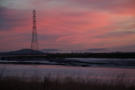
This is becoming a habit: the autumnal dawn walk. In 2011 we watched the sun rise over gas terminals near Barrow in Furness. Last year it was the post-industrial mining landscape of West Cornwall. Today we saw dawn break as we completed the last few miles of the River Parrett.
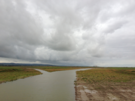 The coast path we walked today won't be here much longer. Inland the Steart peninsula is about to be converted into a huge new wetland. Artificial river channels have been dug and before 2014 is out the bank of the Parrett will be pulled down to allow the waters to flood in. We felt privileged to be some of the last people who'll walk this path.
 We joined the West Somerset Coast Path and soon crossed another sea defence that is under threat, this time from the Bristol Port Company. The plan is to flood this second section of the Steart peninsula to compensate for land reclaimed from the sea in creating a new container terminal at Avonmouth.
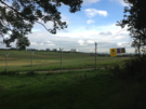 A little further on we met another change to the path. EDF plan to build a new nuclear power station at Hinkley Point, and in what appears to be a tactical move a vast area of land has been fenced off and all public rights of access revoked. We had to resort to walking just outside the perimeter fence: two miles of chain-link topped with barbed wire and adorned with copious warning notices about dogs and CCTV. A dirt road ran just inside the fence line, and as we were reaching the end we met a couple of patrols who presumably were tasked with checking we were not a threat. The whole affair made us feel uncomfortable and guilty even though we were clearly weren't.
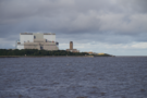
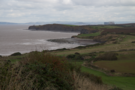 Beyond Hinkley we enjoyed five miles of rolling cliff tops, the path now significantly more popular than earlier in the day. The naval firing range at RNAS Lilstock was just hoisting its red flag and provided the sole diversion from the farms and hamlets. Across the Bristol Channel we could clearly make out the towns and hills of South Wales.
 Suddenly the Quantock Hills closed in on the coast and we had to take one final diversion inland. There is no formal coast path west of Quantock's Head so we joined the treacherous A39 for a final half mile into West Quantoxhead. I expect we shall return when the England Coast Path has forged its more coastal route here, but for now that is just a future coast path.
Notes for future walkers:
- We stayed on the bank of the River Parrett to ST 279 454, from which point a temporary path led us to Steart village.
- Once the seawall has been breached there will be a new path heading round the western side of the wetland from a point near ST 263 437.
- If the Bristol Port Company project goes ahead, the land seaward of Stockport Bristol may be flooded, necessitating a detour through the village.
- We found no mention of the Hinkley diversions online. The path is along the coast to the west of the current power station is closed. The diversion follows the path from ST 217 461 to the access road at 207 453. Cross the road and follow the perimeter fence, which after a loop follows the road south to ST 207 447, then west to ST 198 447 and then more-or-less north to the cliff top at ST 194 461.