Saturday, 5 October 2013
Coastwalk
Clevedon → Weston-super-Mare
 Distance: 20.12 miles
Ascent: unknown
Duration: 6 hours 28 minutes
A tale of two piers
« Portishead | Highbridge »
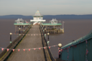
We started today's walk at one pier and ended at another. They could not have been more different and between them, the route was anything but straightforward.
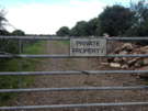 "Private" is a curious word. It can be a polite but assertive request, but when painted in black with rough capital letters on a shabby piece of wood bolted to a gate topped in curls of barbed wire, it takes on a more sinister, threatening tone. "Private" is a word that extended today's walk on three separate occasions. (We wouldn't ordinarily start a week's walking with a twenty-mile tramp.)
The trickiest point between Clevedon and Weston-super-Mare is crossing the River Yeo. The most coastal right of way that crosses it is the M5, which of course isn't an option for walkers!
In 2006 North Somerset Council expressed an intent to create The Tidal Trail: a path along sections of coast where there is presently no public right of way. Unfortunately, once the Marine and Coastal Access Act gained royal assent, the council suspended these plans, choosing to wait for Natural England to spend their money creating this path rather than spend the Council's. This is the sole negative impact of the act that I have come across.
 Sometime later, a group of local cyclists picked up the baton instead, calling for a cycle route across a sluice on the river. I've been monitoring progress for a few years now, and have reluctantly come to accept that I can wait no longer: we'd have to walk the detour.
"I don't want a cycle path," a dog-walker told us. "They come up behind you so quiet" she explained.
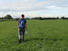
 So more road walking followed, then a farm track (where we found a freshly laid egg in the verge!) before crossing the motorway, diverting through an orchard and lush meadow, sneaking along an embankment, then following a right of way that a farmer had done his best to block up, and eventually back onto a road.
On the road a car kicked up a stone that struck me on the chest. Alarmed, I clasped my hand to where it hit and clearly looked sufficiently surprised that a subsequent driver stopped to check that I didn't need urgent cardiac attention!
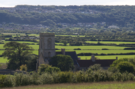 Many lanes later we reached Woodspring Priory and another "Private" sign that kept us from exploring its grounds. Here though is a legal diversion: a small sign points east to a National Trust car park from where the headland of Middle Hope can be reached.
On the headland we met a butterfly enthusiast: a bowed old man in a black suit and a deerstalker hat. He was delighted to recount tales about the local landscape, landmarks and stories of the sea but when expounding on the butterflies to be found on the headland he was completely in his element.
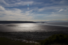 Once off Middle Hope we picked up a path along the back of Sand Bay and, ice-cream in hand, managed to at last make some swift progress.
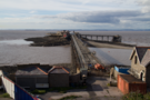 All too soon the path ended and we took to the tarmac again around Kewstoke Road past the dilapidated Birnbeck Pier to the Grand Pier at Weston.
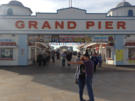 The Grand Pier is a new pier: a replacement for the one that burnt down five years ago. The replacement may be free to walk down, but it is jammed full of attention-grabbing machines and stalls, desperate to make you part with your money.
The contrast with Clevedon Pier couldn't be clearer. You may have to pay to walk the length of Clevedon's pier, but there's a simplicity and honesty about its business model: pay to visit, with no further pressure. We couldn't wait to get away from Weston.
Notes for future walkers:
- It's possible to cross the Blind Yeo on a sluice at its mouth, then follow a permissive path for a kilometre or so to ST 385 694. Don't go too far; the path continues to the end of the next field, but the only route back to the road leads from this point to the corner on Lower Strode Road between Lower and Downlais Farms.
- To cross the M5 use the bridge at ST 401 660; the apparent crossing just north of Phipp's Bridge isn't possible.
- South-west of Phipp's Bridge we managed to sneak along the embankment to the Oldbridge River, despite there being no right of way.
- The bridge over Oldbridge River at ST 390 648 was blocked by farm machinery and threatening signs, but this is a public footpath. (Payback for walking the embankment?)
- Just south of Woodspring Priory, at ST 345 660 follow the track north-east to reach a National Trust car park, then take the embankment to the north before climbing towards St Thomas's Head.
- Instead of playing chicken with cars on Kewstoke Road around Wolebury Hill it might be better to go a short distance into the woodland where a path appears to follow the road reasonably closely.