Wednesday, 26 June 2013
Cleveland Way , Coastwalk
Robin Hood's Bay → Runswick
 Distance: 15.88 miles
Ascent: 555 metres
Duration: 5 hours 43 minutes
Coast to Coast
« Scarborough | Saltburn-by-the-Sea »
 Yesterday, and again today we met "coast-to-coasters". Yesterday's was a man waiting at the bus stop in Robin Hood's Bay having finished his two week walk from St Bee's Head in Cumbria. Today's was a young couple just starting on the walk to the west. It's astonishing to consider that we've almost completed a continuous route between the two ends of Wainwright's walk ourselves, only we took the long way round from St Bee's Head. It's daunting to realise that ahead of us is pretty much the same distance again, this time via the north of Scotland.
Today's walk took us through Whitby, another town that I've been looking forward to visiting for many years.
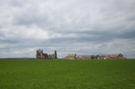
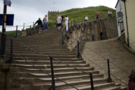 Approaching Whitby from the south is arguably the best route in, since the abbey ruins are the first thing you come to, and you can appreciate them at their most tranquil before dropping down the "199 steps" into the bustling, Dracula-laden, tourist trap of a town centre.
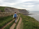
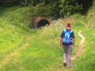
Although we'd planned to stop in Whitby we had time on our side so pushed on. Sandsend is at the western end of the beach that starts at Whitby, and from here the coast path follows a disused railway track for a mile or so through the remains of old quarries where the ghosts of industry seem very real. When the railway drills into a tunnel through the cliff, the path ascends steeply to the top before meeting the old railway again a couple of miles further on near to the other tunnel portal.
On this leg we also started seeing evidence of the North Sea Trail. It's an ambitious project to create an international walking route around the entire North Sea. It's a bit of a dot-to-dot in the UK, so not well waymarked yet. I expect we'll see more evidence of it as we head into Scotland in the coming years.
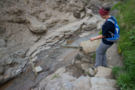
Eventually the path dropped to the beach once more, this time by a route shared with a stream. Literally shared: a handrail led down rough steps into the water where a fingerpost was cemented into a rock in the middle of the flow of Widgeytoft Gill. On this relatively dry day we managed to get by without getting wet, but I imagine in a time of flood it's very different.
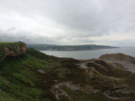
Down on the Runswick Sands curious caves cut half-way up the cliff are known locally as Hob Holes. Looking back it's difficult to imagine there's a route up the cliffs here.
At the far end of the beach is the village of Runswick Bay. Once again, it's a cluster of houses clinging to the steep slope. The frequency with which we're coming across such settlements makes me wonder what Clovelly thinks it has that's so special.
Sadly the bus stop was in the "top" village, so the day ended on one final climb up the narrow winding paths.