Friday, 28 June 2013
Coastwalk , Teesdale Way
Marske-by-the-Sea → Middlesbrough
 Distance: 13.49 miles
Ascent: 77 metres
Duration: 4 hours 35 minutes
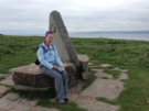
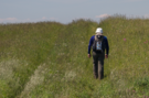
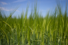
The Black Path was green
« Saltburn-by-the-Sea | Port Clarence »
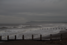
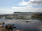
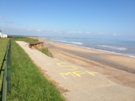
We set off in the drizzle, but by the time we reached Redcar the rain was solid.
 Redcar is another town that's the lucky recipient of a smartened-up prom. And like many such towns, it tends to just draw my eye away from the prom and into the town. Redcar is another town that could do with smartening up more than the prom.
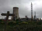
Almost synonymous with the steel industry, the town celebrated when the blast furnaces were re-lit in recent years. Hopefully this return to industry will continue.
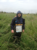
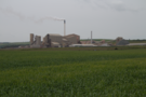
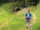
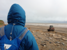
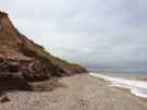
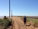
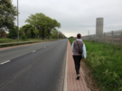
Out of the town it was industry all the way to Middlesbrough. The coast walker has two equally unpleasant options: either walk on the side of a dual carriageway, or take the "Black Path". We chose the latter. After all, it's part of the waymarked "Teesdale Way" - it should be beautiful, right?
The Black Path is a historic route that's now squeezed between various heavy industries. Traffic free, and largely full of overgrown shrubs, waist-high grass and brambles luscious greenery, it could be a really interesting walk. Unfortunately the heavy rain meant that we were struggling through soaking undergrowth, and at one point found the path completely flooded. Even the planks of wood which others had used to get across were floating uselessly in the middle of a black pond.
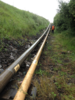
Eventually we gave up. When we reached the Tees Dock Road we started looking for ways off the path and onto the highway. There are two places where lattice footbridges provide a safe route between path and road without having to clamber over the many pipes. (One pipe labelled "Heavy Fuel" was adjacent to another labelled "Oxygen". What could possibly go wrong?)
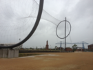 From there it was a road walk all the way to the Transporter Bridge over the River Tees, where we elected to stop: exhausted and soaked through.
That's more than enough for this week. We'll be back to tackle more industry as we cross the Tees and head towards Hartlepool, Sunderland and The Tyne next time.
Notes for future walkers:
- Keep a close lookout for the place the bridleway turns south across the Cleveland Golf Course at NZ 580 255 — when we walked it the post was there, but the waymark disc was missing. Looking across the fairway we saw a complete waymarked post which confirmed the route.
- The start of the Teesdale Way at NZ 582 250 could be easily missed. Look out for a small alley by a substation.
- If you must walk The Black Path, be prepared to moan about it.
- If you've had enough, it's possible to leave the Black Path onto the A1053 Tees Dock Road at NZ 552 221.
- From the Tees Dock Road we walked south to the A66, which we crossed. We then walked parallel on Bolckow Road before crossing the dual carriageway again to follow Eston Road, then Puddlers Road and Normanby Road to South Bank railway station. After crossing the railway we followed Smith's Dock Road, Dockside Road and The Leeway to the football stadium before turning right up an alley to join Shepherdsdon Way. From the end we crossed the dock gates on the new footbridge and followed Scott's Road, Vulcan Road and Ferry Road to the Transporter Bridge.
Thursday, 27 June 2013
Coastwalk
Saltburn-by-the-Sea → Marske-by-the-Sea
 Distance: 2.33 miles
Ascent: 21 metres
Duration: 53 minutes
Oh I do like to be ...
« Runswick | Middlesbrough »
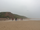
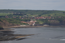
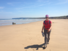
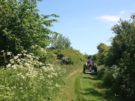
We may have finished the Cleveland Way for the week, but since we're staying in Marske there was still a short walk along the beach to finish the day off.
The tide was out so we stayed on the beach. With Saltburn pier behind us, it began to rain. This didn't seem to deter the group of people playing cricket on the sand though. "The perfect English summer image," Em observed.
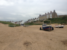
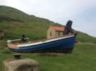
Marske itself is a curious place, a coastal village with no real presence on the coast. It's mostly hidden behind dunes and low cliffs with just one slipway to give away its existence. The village is functional rather than dressing: somewhere to sleep, not necessarily somewhere to play.
Cleveland Way , Coastwalk
Runswick → Saltburn-by-the-Sea
 Distance: 12.50 miles
Ascent: 427 metres
Duration: 4 hours 40 minutes
Towards industry
« Robin Hood's Bay | Marske-by-the-Sea »
This was our final walk on the Cleveland Way for now. (I imagine we'll be back to complete the inland stretch of the National Trail some time in the future.)
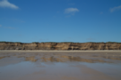
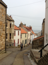 While a pleasant enough walk, it felt like we were just ticking off what we've come to expect of the North Yorkshire coast today. In Staithes we had a traditional fishing village turned tourist trap, complete with steep and winding cobbled streets and narrow fisherman's cottages arranged in the gap in the cliffs.
 As we approached the village, the dragon's-breath steam from Boulby Mine drifted into view in the distance, marking a distinct transition into more industrial territory. This potash mine is the second deepest mine in Europe, making it the ideal place for a deep dark matter laboratory.
 Soon the mine was out of view and we were climbing Boulby Cliff, often cited as the highest point on the East Coast. We descended towards Skinningrove, overlooked by a large steel works, and the drizzle began to fall. We were certainly heading towards a more industrial landscape.
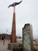
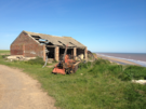
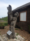 In the village, three large wooden sculptures serve as reminders of the area's past. We were particularly taken with one outside the pigeon fanciers' loft; keeping pigeons has long been a regional tradition, and the memorial here marks the importance of carrier pigeons during the war. There was something quite moving about the story of how local skills and knowledge were placed at the centre of national security.
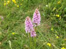 We made a mistake leaving Skinningrove. Rather than follow the path at the back of the dunes, we stayed on the beach and had to double-back to find the route up the cliffs. As a reward for the extra effort we were treated to a dune populated with wild orchids.
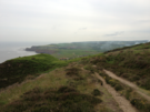
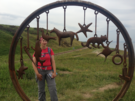 Atop the cliff, the path takes a broad sweep around Warsett Hill, and it's worth stopping here to look out for the several sculptures placed near the cliff edge, perhaps trying to distract visitors from the freight railway that threatens to push the path over the edge.
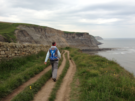
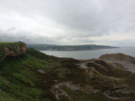
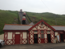 Rounding the corner, more industry came into view: Redcar, Middlesbrough and Hartlepool promise to be a steady progression of pipes and chimneys. First through is Saltburn, and here the Cleveland Way leaves the coast at the popular Victorian spa resort, but we'll be continuing ahead with a few miles of wide sand and an unbroken view out to the North Sea.
Wednesday, 26 June 2013
Cleveland Way , Coastwalk
Robin Hood's Bay → Runswick
 Distance: 15.88 miles
Ascent: 555 metres
Duration: 5 hours 43 minutes
Coast to Coast
« Scarborough | Saltburn-by-the-Sea »
 Yesterday, and again today we met "coast-to-coasters". Yesterday's was a man waiting at the bus stop in Robin Hood's Bay having finished his two week walk from St Bee's Head in Cumbria. Today's was a young couple just starting on the walk to the west. It's astonishing to consider that we've almost completed a continuous route between the two ends of Wainwright's walk ourselves, only we took the long way round from St Bee's Head. It's daunting to realise that ahead of us is pretty much the same distance again, this time via the north of Scotland.
Today's walk took us through Whitby, another town that I've been looking forward to visiting for many years.
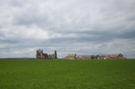
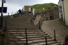 Approaching Whitby from the south is arguably the best route in, since the abbey ruins are the first thing you come to, and you can appreciate them at their most tranquil before dropping down the "199 steps" into the bustling, Dracula-laden, tourist trap of a town centre.
Although we'd planned to stop in Whitby we had time on our side so pushed on. Sandsend is at the western end of the beach that starts at Whitby, and from here the coast path follows a disused railway track for a mile or so through the remains of old quarries where the ghosts of industry seem very real. When the railway drills into a tunnel through the cliff, the path ascends steeply to the top before meeting the old railway again a couple of miles further on near to the other tunnel portal.
On this leg we also started seeing evidence of the North Sea Trail. It's an ambitious project to create an international walking route around the entire North Sea. It's a bit of a dot-to-dot in the UK, so not well waymarked yet. I expect we'll see more evidence of it as we head into Scotland in the coming years.
Eventually the path dropped to the beach once more, this time by a route shared with a stream. Literally shared: a handrail led down rough steps into the water where a fingerpost was cemented into a rock in the middle of the flow of Widgeytoft Gill. On this relatively dry day we managed to get by without getting wet, but I imagine in a time of flood it's very different.
Down on the Runswick Sands curious caves cut half-way up the cliff are known locally as Hob Holes. Looking back it's difficult to imagine there's a route up the cliffs here.
At the far end of the beach is the village of Runswick Bay. Once again, it's a cluster of houses clinging to the steep slope. The frequency with which we're coming across such settlements makes me wonder what Clovelly thinks it has that's so special.
Sadly the bus stop was in the "top" village, so the day ended on one final climb up the narrow winding paths.
Tuesday, 25 June 2013
Cleveland Way , Coastwalk
Scarborough → Robin Hood's Bay
 Distance: 14.86 miles
Ascent: 675 metres
Duration: 5 hours 41 minutes
The landscape is really asserting itself now: we are in hill country again. This isn't a big surprise since we're approaching the Exe-Tees line: an imaginary boundary (as I learnt in secondary school geography) that roughly separates upland and lowland Britain.
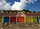
 Leaving Scarborough's North Bay we passed colourful beach-huts, a derelict cable car and a busy-looking aquarium before reaching the cliffs again.
Further on we passed another imaginary point, and I'm disappointed that we didn't stop to look for it. The Ordnance Survey's National Grid is the basis of all OS maps. A Grid Reference is a simple way of referring to a point in the UK; conventionally it starts with two letters (which identify the 100x100km square in which the reference lies), followed by an even number of digits. Almost all grid references in the UK begin with one of four letters: H, N, S and T. Today we crossed the line that separates the H and N grid references from the S and T ones. In fact, over the course of ten minutes we were in the T 500km grid square, then S and finally N. This doesn't happen anywhere else. (Sadly we have no photographic evidence of this moment.)
More exciting than that is the fact that a tiny spot of land at the base Beast Cliff just south of Ravenscar has the distinction of being the only place in the UK with a grid reference that doesn't start with one of those letters. OV 000000, we came so close to you but failed to pay you a visit. I'm sorry.
As for the path, it's been a good day but we've not really felt "into" the walk. Maybe that's what comes of walking straight after a festival.
 Highlights were the quiet hamlet of Ravenscar, a would-be holiday resort that never was, and the tight-knitted streets of old Robin Hood's Bay.
The landscape and Robin Hood's Bay itself both felt very reminiscent of the Cornish coastline that we've come to love over recent years, at the other end of the Exe-Tees line.
Sunday, 23 June 2013
Solas
Solas 2013: Imagination State
There's a new exuberance around Solas this year. Is it the new site, the new outdoor mainstage or maybe just the surprisingly sunny weather?
The new site may mean be another hour and a quarter's drive for us, but it was more than worth it.
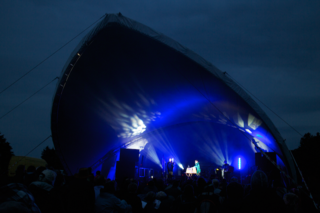
The highlight of each day for me was the Festival Club: an open-mic running into the wee small hours shared by festival-goers and booked artists alike. Where else would you see one act that melded an account of an argument between two old men in Gaelic with pre-feminist Swedish advice for young women?
Solas has a heart and a character that is difficult to ignore.
Thursday, 20 June 2013
Places
Scone Palace
 Scone is a significant landmark in the Perth area, and it's certainly marketed as such: a rich mix of legend, royalty and unverifiable history with a gloss of ancestral prestige.
We expected quite a lot from this former crowning place of Scottish kings. What we got was a disappointing and overpriced stately home.
Undoubtedly, there's a lot of genuine historical interest here, but it's outweighed by the dynastic story of the Earls of Mansfield who own the estate; maybe some of the ancient history is just too intangible to prove. The overall impression was one of a sub-Hello! celebration of inherited wealth and privilege - if you're in any doubt about this, walk down to the gardens and read the display about how the Scone villagers' houses were moved and their thoroughfare through the grounds blocked because the lords of the manor didn't want them coming close to the Big House - rather than a sense of Scone's importance in Scotland's national story.
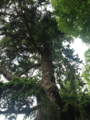
The day was redeemed by a visit to pay our respects to an ancient relic of a different kind. The Douglas Fir standing in the Palace grounds was grown from a seed sent from America in 1827 by the eminent plant hunter David Douglas, who was born at Scone and had worked as the Palace's gardener. It seemed fitting that such a lofty monument honoured a humble and self-made man.
Saturday, 8 June 2013
Cleveland Way , Coastwalk
Filey → Scarborough
 Distance: 11.32 miles
Ascent: 300 metres
Duration: 3 hours 54 minutes
The Cleveland Way
« Bridlington | Robin Hood's Bay »
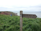
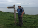 The Cleveland Way is a National Trail that skirts two sides of the North York Moors, running from Helmsley up along the escarpment to Saltburn-by-the-Sea, then along the coast to Filey. Consequently for the next few walks route-finding will be simple: follow the acorn way marks.
Most of that will be for another time though; we're heading home today.
 Running inland from Filey Brigg is another National Trail. The Yorkshire Wolds Way ends its 79-mile journey from the Humber Bridge here. Another walk for another day.
We started early partly so that we wouldn't be too late home, but also so that we could meet up with our friends from York who are having a day by the sea. It's always good to catch up with friends en route, even if we weren't exactly blending in with the beach-ware at Scarborough.
 At Cayton Bay the path was diverted so we headed into Scarborough on the road. An elderly man heading the same way started chatting. He was walking on doctor's orders following a recent heart transplant. Oh that we all recover from surgery quite as well as he!
 Scarborough was both a disappointment and a delight. Dominated by two bays that are separated by a castle-topped headland, the town seems to keep its tidy face in the north bay and its tourists in the south.
Friday, 7 June 2013
Coastwalk
Bridlington → Filey
 Distance: 19.22 miles
Ascent: 405 metres
Duration: 6 hours 21 minutes
Footpaths
« Hornsea | Scarborough »
 At last we've spent a day without trespassing! Filey and Bridlington are separated by Flamborough Head, the last big headland we'll meet before Scotland. Around the edge, a recreational path — The Headland Way — seems to be a popular route for walkers and runners alike. ("Welcome to e'Yorks!" said an elderly man as he sprinted past.)
The southern cliffs are beautiful, with a clear horizontal boundary where the bolder clay that we've been walking on all week is being pushed up and out of the way by chalk. The landscape has really changed, and there's a strong sense that the wide sandy beaches that have been with us since The Wash are now in the past. Ahead it's all headlands and hills!
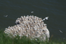 The cliffs — especially on the northern side — were packed with birds, whose constant circling and crying was almost as evocative as the ammonia tang emanating from their nests. At an RSPB reserve a Dutch volunteer encouraged us to use his telescope to view a gannet chick on a sea stack.
 Further along, just beyond the East/North Riding border the public footpath heads inland, and two large holiday parks would present obstacles for anyone wanting to continue on the clifftops, but we dropped onto the beach by a way-marked permitted path and enjoyed the final six miles into Filey on the sand.
 The sun's been out today, which brings me to a final warning. Looking at my shoulder this evening it would appear the white stripes in my Helly Hansen LIFA top aren't as good at blocking UV as the blue stripes. Still, it makes for an interesting effect.
Notes for future walkers:
- The walk around Flambrough Head itself is easy and a public right of way.
- At Speeton Cliffs (TA 153 753), instead of following the public footpath inland, we took a steep signposted path which dropped us on the beach at TA 154 754.
- We followed the beach the rest of the way to Filey, although suspect that this will not be possible for about two hours each side of high tide.
- (Our backup plan was to find a route through the holiday parks at Reighton Sands and Primrose Valley. You can find site maps online easily enough; I suspect it would involve turning a blind eye to "residents only" signs.)
Thursday, 6 June 2013
Coastwalk
Hornsea → Bridlington
 Distance: 13.70 miles
Ascent: 83m metres
Duration:
You shall not pass
« Withernsea | Filey »
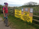
A very careful look at the map shows the bridleway leading north out of Hornsea has a hundred metre gap at Double Gates. A sign on the ground points out that those continuing do so at their own risk. This was positively welcoming compared to a sign we saw a little later.
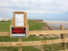
 Generally we've been trying to respect landowners' wishes when walking along the East Yorkshire coast. Today, one passive-aggressive sign was too much, and I refused to be deterred.
"Pardon my French," said a local dog walker after telling us what he thought of them as we climbed back onto the public highway past even more 'Keep Out' signs. "They're just annoyed," he went on to explain, "their land tumbled over the edge so they've had to buy another strip from the farmer."
 For the rest of the day we felt positively welcomed, despite the fact that once again we were generally not on rights of way. Mostly these paths were through caravan parks that we came to know by their unique selling points: the one with the Costa; the one with the golf course; the one with the CCTV; the one with the Camelot amusement arcade; the one with the road falling into the sea; the really lovely one.
 Beyond Barmston wide sands beckoned so we dropped onto the beach. A stretch further up is used by naturists, and as we passed one man was filming his partner who must have dropped a contact lens while getting dressed since she was crawling around on all fours a fair bit. [Ed: I'm not sure his filming was that innocent, actually.]
 Eventually the prom came into view and we made our way into Bridlington, stopping on the northern side of the harbour, ready for another long day tomorrow.
Notes for future walkers:
- The clifftop path out of Hornsea is rapidly disappearing. We managed to follow it as far as the southern prong of the tuning-fork shaped Belvedere Park (TA 205 487), then turned onto Cliff Road.
- At Double Gates, there's a gap in the bridleway past the sailing club, but we had no trouble. From Cliff Road Atwick, we walked north on Long Lane. Where the public footpath comes to an end (TA 190 521) it's possible to continue through the next two caravan parks and past the golf course at Out Lees.
- Withow Gap (TA 183 546) is where we encountered passive/aggressive "keep out" signs. If they deter you, a field-edge route may be possible. We were not able to determine where it would be possible to climb from the beach back up to the clifftop if you choose the lower option.
- A sign on the field north of Hornsea Lane Skipsea (TA) requested only those with permission continue on the clifftops, but a man we met on the road said we'd be fine. (We were.)
- Approaching the caravan park above Tranmere Cliff we remained in the fields, following the park boundary to the left, and the left again until we could pass through the hedge to the road at TA 175 561.
- North from Cobble Gap, enter the caravan park at TA 176 562, landward of an amusement arcade. Turn right at the junction at TA 176 564, follow the track to the left, then turn right again at TA 176 565 before leaving the park in the north-east corner at TA 176 566. This drops you onto Southfield Lane which can be followed north to Sand Lane, Ulrome.
- The next caravan park is easy: stay close to the clifftop.
- After leaving the park at TA 173 576, we remained on the clifftop paths past the end of Sands Lane, Barmston (TA 169 593) before dropping to the beach at TA 170 598
- We walked the beach the to the end of the prom at Hildethorpe (TA 174 650).
Wednesday, 5 June 2013
Coastwalk
Withernsea → Hornsea
 Distance: 19.53 miles
Ascent: 164 metres
Duration: 6 hours 23 minutes
Next stop: North Pole
« Easington | Bridlington »
The glorious weather of recent days was never going to last. The rain broke as we headed north from Withernsea.
 A few hundred metres south of the Sand le Mere caravan park near the village of Tunstall, we met our old friend the Greenwich Meridian for the final time. In fact, this anonymous cliff is the most northerly point that the meridian touches land; from here on up it's water and ice all the way to the North Pole.
 Sadly there was no monument or marker to celebrate this fact. Then again, given the erosion that we saw during the day, perhaps any marker doesn't stay long before it follows the invisible line off the cliff, along the beach and into the sea. (One cottage perhaps a kilometre from the end of Seaside Road in Aldbrough was prophetically named "Cliff Top Cottage To-Be".)
One advantage of "off-piste" walking was the wildlife we saw. At Bracken Hill a young deer bounded for the hedgerow just before us, although Emma was more fascinated by the hedgehog rapidly making his way across the next field.
 The second half of the walk was rather disappointing. We scouted the route out yesterday and seeing that the old RAF range at Cowden Parva is still marked with "danger keep out" signs, and on its northern boundary farms are built right up to the clifftop, we walked the rest of the way into Hornsea on the main road.
It might have been possible to walk this stretch on the beach, but the fact that the concrete slipway at Mappleton was built to provide access for the bomb disposal squad, and the knowledge that just last year hundreds of unexploded ordnance were found on the beach confirmed that we made the right decision.
 In Hornsea a monument on the prom marks the eastern end of the Trans-Pennine Trail. We last met this in Hull; we'll hopefully meet its western end later in the year in Southport.
Hornsea itself seems pleasant, but has an unusually large number of mobility scooters. This is something we've come to expect from East Yorkshire coastal towns.
After a long walk by the sea there's only one thing left to do, and the same taxi driver who tipped us off to the correct pronunciation of "Withernsea" came good with a recommendation of Whitehead's chippy. It's tucked away on an estate very close to where we began our descent to the prom. If I did this walk again I'd buy a bag of chips en route for that final mile.
Notes for future walkers:
- North of Withernsea there's no trouble sticking to the clifftop path as far as the caravan site at Sand Le Mere.
- Beyond the caravan site we continued along the cliff tops on the public bridleway, then the remains of the road that joined Pastures Lane to Hogsea Lane (TA 302 331).
- From Hogsea Lane (TA 300 333) we continued on the cliff top past Tunstall Pastures to the edge of the Grimston Garth estate.
- At TA 289 349 we followed the fence curving left to join the public footpath at TA 284 343..
- At Moat Farm we took the road inland, the bridleway north from TA 272 354 to Grange Farm.
- We followed the road towards Aldbrough, then at TA 259 386 took Old Dale Road to rejoin the clifftops which we followed to the end of Seaside Road at TA 256 395.
- Not ones to mess with MoD land, we followed Seaside Road into the village, following a bridle way to TA 244 390, then another (Mill Lane) west to the B1242.
 I would not recommend dropping to the beach at Mappleton unless the tide is low enough to allow walking the rest of the section below the cliffs.
- In Hornsea, we took the third road on the right (Ranby Drive) off the B1242 at TA 203 466, then third right again onto Ebor Avenue (TA 205 467), right onto The Crescent (TA 206 468), and right again onto Hornsea Burton Road (TA 205 470) which we followed to the seafront.
Tuesday, 4 June 2013
Coastwalk
Easington → Withernsea
 Distance: 8.26 miles
Ascent: 95 metres
Duration: 2 hours 47 minutes
Trespassing
« Skeffling | Hornsea »
Today's walk sets the tone for the rest of the week: we shall be trespassing.
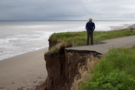
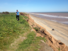 The East Yorkshire coast is being eroded at such a rate that rights of way have a nasty habit of tumbling over the clifftops and into the sea. It's said that the coastline here is receding at a rate of 2.5 metres a year - faster than anywhere else in Europe.
Consequently there are no public footpaths that coastwalkers can use, and instead we followed our noses, generally keeping to the unfarmed strip that marked the very edge of the land.
 It was easy going and we weren't challenged at all, and only once had to clamber down/up a gully. We eventually headed inland just south of Withernsea to avoid an airstrip built on the cliffs.
Factoid of the day is that Withernsea seems to be East Yorkshire's shibboleth. If you want to blend in with the locals, emphasise the "n", as if it's a contraction of "Wither-on-Sea".
 Walking the promenade, we passed a couple of references to churches (and presumably, villages too) that had been lost due to coastal erosion. Reminiscent of the stories of the 'drowned churches' of Suffolk, it was slightly eerie to imagine the extent to which the land has been lost over the intervening centuries.
Notes for future walkers:
- A well-used permitted path runs on the seaward side of the gas terminal at Easington. This can be reached by walking east on a field-edge path from the top of Vicar's Lane at TA 400 194.
- We continued on the cliff-top path along Dimlington Cliff, past Cliff Farm, over Old Hive Dike to School Lane, then Seaside Road in Holmpton.
- Old Hive Dike was deep and dry, but crossable with just a little clambering.
- From the end of Seaside Road (TA 372 240) we continued on the cliff top path but headed inland at TA 360 258 at the track just north of the sewage works.
- We then followed Holmpton Road (no pavement) to the outskirts of Withernsea, turning right on Oak Avenue and again on Seacroft Road before picking up the prom at TA 348 271.
Monday, 3 June 2013
Coastwalk
Skeffling → Easington
 Distance: 14.49 miles
Ascent: 47 metres
Duration: 5 hours 7 minutes
Under attack
« Paull Holme | Withernsea »
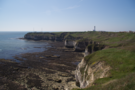
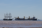
More than once already this week we've been asked, "Have you been to Spurn yet?". Today we finally reached the mouth of the Humber, and stretching out halfway across it for four miles from the northern shore is the great sand spit known as Spurn.
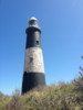 We first caught sight of the black-and-white stripes of Spurn lighthouse six walks ago from Lincolnshire. While the lighthouse was obvious, the shape of the spit was far from clear, since we were looking directly down its length. The lighthouse itself is a mile or so from the tip; the most southerly building is the blocky Humber Pilot Station.
About halfway down, the spit narrows to just 30 metres of sand. The road is regularly re-routed here as the sand moves about. It's thought that in the near future there's a risk that the headland will be cut off entirely, and no doubt this would be the most likely place.
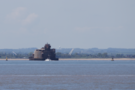 Between Spurn and the southern shore stand two forts built to protect the estuary in the First World War. Demilitarised over fifty years ago, Bull Sands Fort is being slowly being transformed into a detox centre. There are probably deep parallels to draw here.
The most surprising thing we saw beyond the narrowing was a young roe deer. If there's a herd here, they've done a very good job hiding in scant cover.
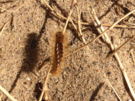 Spurn isn't just under attack from the sea though. Since 2007 it's been suffering from an overwhelming population of brown tailed moth caterpillars. At the entrance to Spurn Yorkshire Wildlife Trust posted copious notices warning visitors to keep away from the larvae, whose barbed hairs are the source of the irritation. That's easier said than done: the caterpillars carpet the headland; long trousers were definitely required.
Last year the final families that lived on Spurn left the peninsula for good. While news articles say it was the threat of being cut off that sent them further inland, I blame the moths.
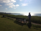
 Rounding the southern end gave us a new view out into the North Sea. For the last seven walks we'd been looking out into the brown waters of the Humber, but the change of direction brought us along the deep blue of the open water and took us away from the ever-present sight of the Grimsby Dock Tower out on the near horizon. Today was a hot and tiring day - walking on the seemingly endless shingle sapped the strength in our legs - and at times it was very tempting to paddle in the surf instead.
 On the final few miles of the walk we passed one more symbol of invasion. "You can't miss the only listed building in Kilnsea," we were told as we bought ice-creams from the Blue Bell Café. The listed building is a sound mirror. I'd previously seen one on the cliffs above Folkstone. It was interesting to see another echo of the early twentieth century wars this far north.
Notes for future walkers:
- We had no trouble continuing on the sea bank after the public footpath ended at Humber Side Lane car park TA 392 171, although we did have to drop onto the beach at TA 406 162 until we reached the Crown and Anchor Inn at TA 409 157. This may be tricky at the highest of tides.
- From the Crown and Anchor another permitted path runs south-east to join Warren Road at TA 417 152.
- The walk to Spurn Point itself is easy: take the road. The footpaths on the Humber side were overgrown and not worth it.
- From the car park at TA 401 111, we descended the slipway to the beach, rounded the tip then headed back north on the sea side of the peninsula.
- About halfway back on the east side (TA 418 129), the tide squeezed us against crumbling sea defences so we clambered over the dunes to rejoin the road.
- At the northern end of the spit, we initially walked on the beach but soon climbed the low cliff and followed the clifftop to the car park at TA 417 158.
- We followed the road inland to the Blue Bell Café (good for ice creams!) at TA 415 158, then went north on the road. At TA 414 166 we took a permitted path to the west which soon turned north in front of the sound mirror and continued on the landward side of the lagoons, eventually joining New Bank to the road at TA 407 187.
Sunday, 2 June 2013
Coastwalk
Paull Holme → Skeffling
 Distance: 16.64 miles
Ascent: 17 metres
Duration: 5 hours 22 minutes
Landmarks
« Kingston upon Hull | Easington »
Yesterday we talked of physical landmarks. Today we crossed two invisible thresholds.
Just a few miles into the walk we reached the three thousandth mile of coast walking. (Remember: we've not been walking in order, and with a couple of gaps on the west coast yet to be completed, Gretna is somewhat more than three thousand miles behind us.) The first thousand mile mark was on the edge of Morecambe Bay on the east coast of England, the second near Hamble on the south coast; the remaining will all be in Scotland. I'm slightly disappointed we didn't engineer one of the markers to be in Wales.
As has become tradition I looked around for a suitable stone to take as souvenir of the occasion, but on finding none I instead pocketed an inch of wood that had crumbled away from a nearby fence.
 The second of today's thresholds was crossing the Greenwich Meridian for the penultimate time on the walk. With any luck we'll see it again later this week.
These two landmarks are the most interesting thing about the walk; the rest of the day was one long flood bank alongside the Humber estuary.
All day one landmark remained visible inland: the tower of Patrington church. Reviewing our friend John Davies' comments when he visited it a few days before Emma and I married, I feel we missed out.
If you consult a map you'll see there's no right of way for much of the north bank of the Humber. This will become a common theme for our East Yorkshire walks. This area is almost devoid of formal public access, and will likely remain so until the English Coast Path route is agreed.
 To that end, a local arm of the Ramblers Association has published a recommended route, and we are more-or-less following their path. Throughout the week we will add footnotes for future walkers describing the route we took, and any difficulties we encountered.
Notes for future walkers:
- Sunk Island is a Crown property; between Stone Creek and Outstray Farm a permissive path provides reasonable access, although it was thigh deep in thick grassy undergrowth.
- On the east side of the island, the embankment has been breached. From TA 318 180 follow the next embankment inland north-east to TA 328 189.
- Just north-west of Outstray Farm we took a track to the north-east, then turned south-west past a couple of ponds to meet up with a public footpath on Welwick Bank. A farmer was mowing the footpath here and gave us a cheery wave, so he clearly expects walkers. If only he had mown the Sunk Island path too!
Saturday, 1 June 2013
Coastwalk
Kingston upon Hull → Paull Holme
 Distance: 8.68 miles
Ascent: 29 metres
Duration: 2 hours 42 minutes
Hull
« Barton-upon-Humber | Skeffling »
Something I was acutely aware of when first seeing Hull from the south bank of the Humber is how ignorant I was of the city. "Most cities," I suggested to Emma, "have landmark buildings that you can name. But Hull ... ?"
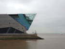 Even from that southern shore there was one building that stood out with crisp, angular precision. Today we walked past it. The Deep is an aquarium appearing to leap wide-mouthed out of the dockside, its cut-out triangular decorations evoking the animal it's clearly most proud of housing: the shark.
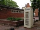 Hull's other obvious landmarks are a little smaller: cream coloured phone boxes. The telephone network here was never nationalised, so didn't become part of BT when Post Office Telecommunications was privatised. Consequently BT are forbidden from operating here and the red phone boxes that are a familiar sight elsewhere in the country are painted cream.
Two things are clear about Hull. First, that it's an economically deprived area. Second, it's doing all it can to reinvigorate itself. The smartened up waterfront bedecked with bunting and flags promoting its City of Culture bid; its vibrant city centre; its "capital city" architecture all make this seem to be a great place to live. The one problem that I can see is what you would do for work here?
As the houses petered out we reached more derelict docks. Alexandra Dock has been earmarked for use as a wind turbine factory, but that looks in doubt this week.
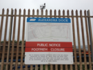 A large sign on the dock told us that the footpath across the lock gates was closed indefinitely, but when we reached them we crossed with ease. The next dock housed the ferry terminal (it was strange seeing a foothpath sign pointing to Zebrugge), and here we believed the "path closed" instruction, diverting onto a pavement beside a busy dual carriageway lined with industry on one side and dilapidated houses on the other.
 After the A-road, a minor road; after the dock, a chemical works smelling of honey-glazed gammon. Eventually we were back on the sea bank and a return to greenery and the estuary.
This will be the last major industry for some time on the coast, but it won't be the last time we're struggling with a lack of rights of way. More on that tomorrow.