Saturday, 13 April 2013
Coastwalk
Wainfleet All Saints → Skegness
 Distance: 13.0 miles
Ascent: 75 metres
Duration: 4 hours 10 minutes
Back on the coast
« Wrangle | Mablethorpe »
The first two thirds of today's walk were on tarmac; the first four miles of it on the carriageway of the A52. Playing on my mind was an image from yesterday: an Audi TT on its side in a ditch, having taken this road too fast. The pavement couldn't come too soon!
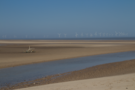 It would have been quite possible to convince ourselves that there was no need to walk south from Skegness to loop around Gibraltar Point (the other bank of the Steeping River), but I'm glad we didn't. We walked along the road down to the nature reserve, but stayed on the beach all the way back to Skegness.
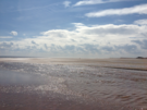 (At the Visitor's Centre we were advised against the beach walk because of the tidal Greenshank Creek, but when we reached it the tide was low and while it was wide, it was shallow enough to be crossed without removing boots, though paddling was refreshing.)
 Skegness is a terrible disappointment. I'm all for a bucket-and-spade resort, but seeing Vodka shots on sale alongside ice creams on the prom set an inappropriate tone. I don't intend on returning.
That's a lie. I might return. Hopefully sometime in the next few years the English Coast Path will reach this point, and the bridge across the Steeping will be open to the public year-round. When that happens, we'll be back to re-walk Wrangle to Gibraltar Point along the sea bank.