Monday, 29 April 2013
Personal
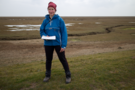
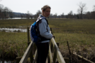
We shall return
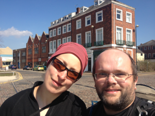
And so our weekend away is over.
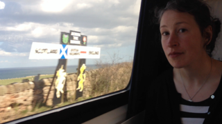
All being well, by this time next year we shall be standing the other side of the sign looking at the trains whizzing across the border.
Angels
Coffee

 Edinburgh's New Town is served well with coffee shops. So well that finding an original name is clearly difficult.
On Brandon Terrace, Coffee Angel. A few hundred yards down the same road (now known as Hanover Street), Urban Angel.
We visited neither — there's only so much cake one should eat in a single day.
Saturday, 27 April 2013
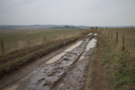
Coastwalk
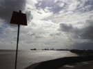
Leith → Queensferry
 Distance: 15.0 miles
Ascent: 91 metres
Duration: 5 hours 1 minute
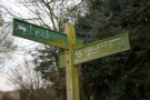
Edinburgh's other fringe
« Aberlady | Aberdour »
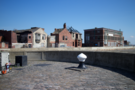
Head north from the Royal Mile and the Old Town; go a little distance beyond the New Town. It's a mile or so. The secret about Edinburgh which tourists seldom see is that it's a coastal town.
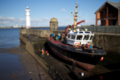
 Leith docks is the easiest point to get to, so our walk started there. These docks are still worked, but investment has poured into the area in a way that's typical of other dockland areas. Now alongside the ships are tourist attractions, towering blocks of flats, cafe-culture-boulevards and government offices (as well as derelict land biding its time). Every so often real life intervenes, a prime example being the still working fishmarket at Newhaven Harbour.
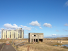
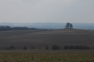
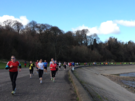 West of Leith, Newhaven and Granton developments, we reached the beautiful parkland of Silverknowes, which is being rebranded as the Edinburgh Waterfront. Here we found ourselves walking against the tide of three hundred runners who congregate at the park every Saturday morning for an informal five kilometre Park Run.
The ferry across the River Almond at Cramond stopped service a decade or so ago, forcing us upstream for a mile and a half through a peaceful wooded riverside walk to the ancient bridge.
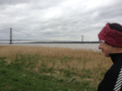
The remaining distance to Queensferry was through the Dalmeny Estate, a country house that is now used for corporate events. There's a cycle path that runs on roads through its grounds, but the coast walker will prefer the Shore Walk, clinging doggedly to the shoreline. Towards the eastern end, this walk passes Eagle Rock, which is reputed to be scarred with a Roman era carving of an Eagle, although Heritage Scotland's notice affixed to the rock comments with deadpan humour "whether it is an eagle or whether it is even Roman is uncertain". (Emma thought it looked more like a penguin.)
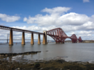 Throughout the walk we have caught sight of our destination: the Forth Bridge. It's impossible to not stop and photograph this modern wonder at regular intervals, and here too we met many locals who were drawn out for a gentle walk now that Spring has finally sprung.
Away from the Castle, beyond the Old and New Towns, here on the Fringes of the city, Edinburgh comes out to play.
Monday, 22 April 2013

Sunday, 21 April 2013
Album , Gig
Ricky Ross: Trouble Came Looking / Live
"It's been an interesting week to launch an album of stories based on the current economic climate," said Ricky Ross towards the start of tonight's gig at the Union Chapel. "I can't help but feel we've been he before," he continued, before laying at least some of the blame at the policies of the recently buried Tory leader.
Ricky Ross has always had a political angle, with most of his works revolving around faith, home and work. His new album "Trouble Came Looking" focuses heavily on the last of these.
Telling stories that are often missed in the striver/shirker dichotomy that media has fallen into of late, Ross begins to sound like a Scottish Woody Guthrie, with a bit of Bruce Cockburn thrown in for good measure.
Trouble Came Looking is an insightful record. It's not particularly deep in meaning, but the voices that it amplifies are well worth listening to: the newly redundant, struggling to make ends meet; the boss trying to keep his business running. We even hear from Morecambe Bay cockle pickers. It could make for depressing material, but through all the songs runs a silver strand of humanity and hope.
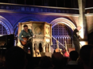 As for the concert, it was tremendous. Drawing from his own solo albums, along with some vintage Deacon Blue material, the thread of workers' tales was unbroken back to Ross's earliest days. And to round it all off, this Dundonian paid homage to another, finishing with a cover of the late Michael Marra's paeon to the hardworking but harmless Scot, "Hermless". A wonderful night, and important album.
Saturday, 20 April 2013
Coastwalk
Barton-upon-Humber → Kingston upon Hull
 Distance: 8.25 miles
Ascent: 53 metres
Duration: 2 hours 43 minutes
Welcome to the north
« Immingham | Paull Holme »
Goodbye Lincolnshire, hello Yorkshire. There's no doubt about it now: we are in "the north".
 Crossing the Humber I was struck that barely 100 miles away, due almost precisely west of here is the Ribble estuary and Preston. For some reason the geography of the two sides of the country are disjointed in my head, and I had to look at a map to see just how far north we were.
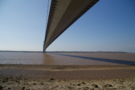
 The bridge is, of course, massive, taking a good 45 minutes to walk across. On the north side, a path leads down through a country park to the shoreline which is the better vantage point from which to appreciate the gigantic structure.
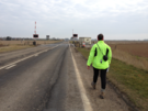
 But rather than hang about, we plodded on. Soon we were passing retail parks, derelict docks then working docks before being plunged headlong into the cafés and offices that bring Kingston upon Hull's waterfront to the same spec as every other quay in the country.
Friday, 19 April 2013
Coastwalk
Immingham → Barton-upon-Humber
 Distance: 17.0 miles
Ascent: 63 metres
Duration: 5 hours 18 minutes
« Cleethorpes | Kingston upon Hull »
 We didn't walk yesterday. The wind has been gusty all week, and recognising that we had a long day ahead of us we didn't much fancy walking headlong into it.
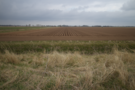
 Despite being a long walk, there's not much to report. It felt similar to the walks round The Wash, largely being back on a sea bank with fields inland. The difference this time was the presence of another shore, as the Humber estuary narrowed and Hull became visible to the north.
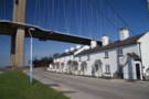
 Soon enough the Humber Bridge came into view, drawing us forwards for the remainder of the day.
We stopped just short of the bridge, saving that definitive moment for tomorrow and the end of our week's walking.
Wednesday, 17 April 2013
Coastwalk
Cleethorpes → Immingham
 Distance: 10.1 miles
Ascent: 345 metres
Duration: 3 hours
Ports
« Saltfleet | Barton-upon-Humber »
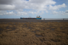
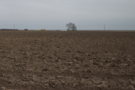
From Cleethorpes, through Grimsby, to Immingham: not the most glamorous of walks.
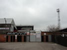 Despite this being a very industrial landscape, there was still plenty to see: the ironic "no ball games" notice on Grimsby FC's gates; the countless fish processing plants, the ever-present Grimsby Harbour Tower; the fields full of new cars, all with their windscreen wipers raised in salute.
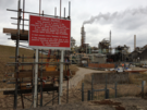
 West of Grimsby we took to the concrete sea wall, looking at the industry which lines the coast here: a power station, plants making titanium dioxide (this one with significantly more scary warning signs), pharmaceuticals, polymers and performance products. If you want to play with chemicals for a living, Grimsby seems a surprisingly popular destination.
 Eventually a fence forced us inland, and for a brief moment we were treated to a delightful woodland walk before being dropped onto a busy road hurrying lorries between factory and dock on the edge of Immingham.
Tuesday, 16 April 2013
Coastwalk
Saltfleet → Cleethorpes
 Distance: 15.7 miles
Ascent: 1225 metres
Duration: 5 hours 19 minutes
Donna Nook
« Mablethorpe | Immingham »
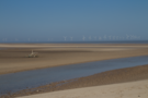
It turns out that the two military ranges which we have previously walked through this week are no longer active. That's not the case for the Donna Nook range which we walked alongside for much of today.
There's no right of way marked on the map here, and you have to walk just beyond the red danger flags, but so long as you stay outside the danger area marked with posts and notices, there is no problem.
At least, there's no problem in April. In November and December it's a different story, when this entire area plays host to a huge colony of seals. We passed a number of signs telling us to stay once side of a fence, for fear of being bitten. Unfortunately there were none in sight today.
 The next obstacle is North Coates airfield. Once again there's no right of way on the sea bank, but once again we made our way without interruption. On the far side, a welcome bridge/sluice across Tetney Haven allowed us to rejoin the footpath network.
 The Environment Agency were busy throughout this section, with Heras fencing forcing us to make various adjustments to our route. The best option would've been to stick close to the dunes at all times.
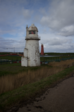
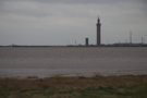
Off to the east we caught our first sight of Spurn Head lighthouse, and the two early 20th century forts that guard the mouth of the Humber.
 Finally we reached Cleethorpes, but not before once more crossing the Greenwich Meridian into the western hemisphere. There are just two more crossings of the meridian on this coast path, both on the other side of the Humber.
Monday, 15 April 2013
Coastwalk
Mablethorpe → Saltfleet
 Distance: 8.40 miles
Ascent: 223 metres
Duration: 2 hours 54 minutes
Behind the dunes
« Skegness | Cleethorpes »
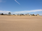
Mablethorpe is the last of the band of Lincolnshire coastal resorts for a while. To confirm this fact, buses don't stray any further north along the coast so a taxi was the order of the day. These resorts have generally got less and less tacky as we have made our way north, but even Mablethorpe carries a few vestiges of guilt.
 Today's walking once again started on wide open beaches, but thankfully the wind has been calmer.
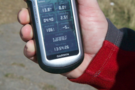
 There's another military firing range south of Saltfleet, and with a beach that extends over a kilometre away from the dunes we chose to cross back to field paths on the landward side of the dunes at the first opportunity. Carrying a GPS receiver made all the difference here since there were scant few landmarks to navigate by. Straying onto the range, or wandering in the dunes forever isn't my idea of fun.
On the approach to Saltfleet, the Environment Agency are busy building up embankments to protect against coastal flooding. With the mean high water still a good kilometre beyond the dunes, it's horrifying to consider the events that they are protecting against.
Sunday, 14 April 2013
Coastwalk
Skegness → Mablethorpe
 Distance: 15.3 miles
Ascent: 608 metres
Duration: 5 hours 3 minutes
So bracing
« Wainfleet All Saints | Saltfleet »
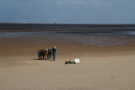
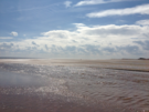
"Skegness is so bracing," said the Jolly Fisherman posters. We completely agree.
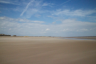 After ten miles even the most beautiful sandy beach gets to be too much. After fifteen miles with the wind hammering the sand against your skin, it's more than time for the torture to end!
The beginning and end of today were on a promenade. The middle section (the vast majority of the walk) was on the soft, sandy beach. Pausing for a rest at Huttoft, the man from the Coast Watch explained:
 "We haven't seen that wall in nine years."
He gestured at a wall that disappeared into the dunes after a couple of metres.
"You know, I used to cycle all the way from Mablethorpe to Skegness," he continued, "but now..."
 The landscape is changing round here. So is the car park. "The council want me gone," he said. The man from the seal sanctuary caravan a few doors down said something similar.
I guess it's easier for the council to do something about oddball characters than bulldoze back the sand that has covered what once must have been a gloriously lengthy prom.
Saturday, 13 April 2013
Coastwalk
Wainfleet All Saints → Skegness
 Distance: 13.0 miles
Ascent: 75 metres
Duration: 4 hours 10 minutes
Back on the coast
« Wrangle | Mablethorpe »
The first two thirds of today's walk were on tarmac; the first four miles of it on the carriageway of the A52. Playing on my mind was an image from yesterday: an Audi TT on its side in a ditch, having taken this road too fast. The pavement couldn't come too soon!
 It would have been quite possible to convince ourselves that there was no need to walk south from Skegness to loop around Gibraltar Point (the other bank of the Steeping River), but I'm glad we didn't. We walked along the road down to the nature reserve, but stayed on the beach all the way back to Skegness.
 (At the Visitor's Centre we were advised against the beach walk because of the tidal Greenshank Creek, but when we reached it the tide was low and while it was wide, it was shallow enough to be crossed without removing boots, though paddling was refreshing.)
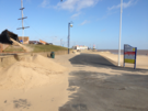
 Skegness is a terrible disappointment. I'm all for a bucket-and-spade resort, but seeing Vodka shots on sale alongside ice creams on the prom set an inappropriate tone. I don't intend on returning.
That's a lie. I might return. Hopefully sometime in the next few years the English Coast Path will reach this point, and the bridge across the Steeping will be open to the public year-round. When that happens, we'll be back to re-walk Wrangle to Gibraltar Point along the sea bank.
Friday, 12 April 2013
Coastwalk
Wrangle → Wainfleet All Saints
 Distance: 8.87 miles
Ascent: 86 metres
Duration: 2 hours 38 minutes
Detour
« Freiston Shore | Skegness »
Here's a secret: we entered a marathon last year. I blame the woman with the dog. Or maybe the Bed-and-Breakfast proprietor.
Let me explain.
There's a public right of way almost all the way around The Wash, but this stops about five miles short of the northern corner. The sea bank continues but it's on private land and the coastal walker who chooses to trespass faces another problem in addition to angry farmers: the Steeping River. This deep channel has to be crossed at the end of the five mile transgression, and while there is a bridge, it's locked and heavily fortified. The only alternative is a long trudge inland on the busy A52. This dilemma - road or trespass - is why it's taken me so long to come back to Lincolnshire.
A couple of years ago we solved the problem. On the bookcase of a B&B in Falmouth I found a copy of Two Feet, Four Paws by Katherine Talbot-Ponsonby. It's another coast walker's journal, and critically when discussing crossing the Steeping she reveals that the gate is unlocked once a year: for the Boston-Skegness Seabank Marathon.
It seemed a little crazy, but why shouldn't we join in?
So around this time last year we sent off our entry forms and waited for the big day.
The day came and went. In the end, two things stopped us from participating. First, the weather was lousy. Second, the race was held on a Sunday when public transport between finish and start was almost non-existent. We resolved to look more closely at logistics and enter again this year.
A couple of weeks ago my heart sank as I looked at the race date: prior commitments meant we wouldn't be able to participate. So the detour (race) that could have saved us from having to making an inland detour was out of the question.
Enough messing around! We'd just have to take the road option.
Things didn't get off to a good start: we'd planned to park at the end and take a taxi to where we'd left off previously, but Wainfleet's only taxi firm was on holiday. So before the true walk even began we had to walk the two and a half miles from the village of Wrangle to the sea bank.
 The sea bank itself made for wonderful walking, providing a slightly elevated view of the expansive flat fields. In one, labourers were sowing a crop by hand. In another, the curly kale was just shy of being ready to pick (again, a manual activity).
 But too soon it was time to head inland. As we neared the A52 we saw blue flashing lights and found a road suspiciously devoid of traffic. At the first junction we were stopped by the Police — they'd closed the road ahead so that the air ambulance could attend an accident. Once again we were sent on a detour.
Finally we reached the Chain Bridge just outside Wainfleet and finished our walk.
It wasn't the day we had planned, but it's been good to get going again and start the campaign for 2013.
Monday, 8 April 2013
Sunday, 7 April 2013
Chilterns and Thames Valley
Riverside meadows
 Distance: 7 miles
Ascent: 100 metres
Duration: unknown
Walk 17: Henley-on-Thames and Hambleden
Some quick thoughts on the countryside surrounding Henley, which we'd previously avoided because of its "hooray" image:
- Plenty of "private" signs down by the river in town quickly give way to:
- delightful woodland and beautiful sweeping arable fields,
- quiet countryside lanes leading to charming village pubs;
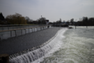
- a thundering weir that interrupts The Thames;
- more villages, and wood-fringed hills;
- peaceful meadows beside the river near
- Temple Island, featured in the London 2012 opening video.
I'm not in a hurry to return to Henley, but walking this circuit was significantly more enjoyable than I'd expected.
Monday, 1 April 2013
Chilterns and Thames Valley
An Oxfordshire Round
With Emma away for the day, it's an opportunity to see if I can stretch myself. Still cautious about my back, I decided to take things one walk at a time and surprised myself by completing all three: an Oxfordshire Round.
 Distance: 4.27 miles
Ascent: 55 metres
Duration: 1 hour 9 minutes
Walk 4: Cuckhamsley Hill and the Ridgeway
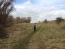
Here in the far south of the county, The Ridgeway ploughs its way across hilltops in deep, muddy, tyre-trodden furrows. It's popular with walkers too, but once you step off the National Trail the paths are deserted, save for the occasional herd of deer. Magical.
 Distance: 4.98 miles
Ascent: 118 metres
Duration: 1 hour 31 minutes
Walk 5: Old Boars Hill
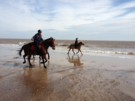
Old Boar's Hill couldn't be more different. This is the Oxfordshire of Tarquin and Jemima. Look! There's Tarquin's new ride, an Audi TT parked next to daddy's SLK. And in the paddock, Jemima's riding out her new run-about. Paths are neatly fenced in here, and plentiful "Private! Keep Out!" signs help you know your place: you don't really belong here.
 Distance: 4.26 miles
Ascent: 90 metres
Duration: 1 hour 21 minutes
Walk 6: Dorchester and Wittenham Clumps
The final walk of the day was the best of the three. The Sinodun Hills rise beside the majestic Thames near the ancient settlement of Dorchester, each crowned with a clump of trees. Here everyone is welcome, as evidenced by the massed ranks of families spread out across the grassy flanks.
All-in-all three good walks, and with a combined distance of 13 miles it looks like I might be ready to start the coast walking again.