Tuesday, 1 January 2013
Coastwalk
The Plan, update 1
After being open about the three-year plan this time last year, it's time to report on how year two went.
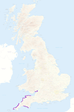
- Walks: 29
- Distance: 316.7 miles
- Countries completed: 1
- National Trails completed: 1
- Rivers forded: 1
- Suspension bridges crossed: 1
- B&Bs visited: 5
Perhaps unsurprisingly given the atrocious weather we've had, the total distance is significantly below last year's. But while we only set out on two thirds of the walks we had planned for the year, we did accomplish the two headline goals: completing the Welsh coast path before it was formally launched, and finishing the South West Coast Path.
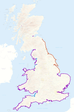 The second map shows plans for next year. The three sections of blue on the west coast are the left-overs from this year: a two-day walk on the Kent Estuary in Cumbria, a three-day walk along the Sefton shoreline and a four to five day walk on the Bristol Channel.
The orange section on the east coast is the headline goal: marching north from the Wash to the England/Scotland border just north of Berwick-upon-Tweed.
That means a total of 480 miles for the coming year. It'd be our biggest year of walking yet. Here's hoping the weather holds out — I'm determined to complete the country by the fifteen year anniversary of starting this walk in February 2014.
[Contains Ordnance Survey data © Crown copyright and database right 2011]