Sunday, 22 July 2012
Coastwalk , South West Coast Path
Perranporth → Portreath
 Distance: 12.0 miles
Ascent: unknown
Duration: unknown
"Is the path open now, then?" asked our taxi driver as he took us to the railway station at the end of the walk. "Only, it was closed earlier because of the plane crash."
"What plane crash?" we asked. We'd not seen the news since leaving home.
 A light aeroplane had taken off yesterday from the local aerodrome, with just the pilot on board. It was probably one of those that buzzed overhead as we were walking from Newquay. In clear skies and with an experienced pilot, the plane crashed into the cliffs just north of Portreath, killing the only person on board.
 "That'll be what the police were doing," said Emma. We'd seen them earlier: a chain of five or six making their way gingerly down the cliff top slope. I'd thought they were on an abseiling exercise and made a light joke with them about it. I feel gutted about this now. Looking back at our photographs, the tail of the plane is visible. It's what I had taken to be an abseil post.
 The crash will be the lasting memory from today's walk, which is a shame because there were so many other things to remember too: starting out at dawn; the motocross trial hill in St Agnes; the remnants of the mining industry. It's been a lovely walk, but tinged with sadness.
There was one other crash too: my GPS reset shortly before ending today's walk, so the weekend's track log is gone and consequently the distance above is an estimate.
Saturday, 21 July 2012
Coastwalk , South West Coast Path
Newquay → Perranporth
 Distance: 10.5 miles
Ascent: unknown
Duration:
Back on track
« Porthcothan | Portreath »
 It turns out that on this walk, the good thing about Newquay is leaving it. While I stand by my previous opinion of the town centre as somewhere best avoided, the west side of the town has some really charming moments.
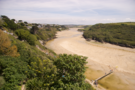
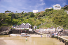 Chief amongst those was crossing the Gannel estuary. We chose the most downstream point to cross: the Fern Pit Café. It's on private land, but freely accessible. The path leads past the café itself, then zig-zags down through a beautiful garden with an alpine feel to the river. At the river a tidal bridge offers free passage to Crantock Beach and a ferry runs when the bridge is submerged. Looking back at the path by which we had descended the headland, the beauty of the setting is unmistakable. This is a place to return to.
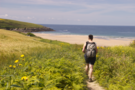
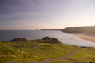
After the Gannel, Crantock, Porth Joke and Holywell: three beaches linked by cliff-top paths lined with bracken. Beyond Holywell, a beach that put the others to shame. Perran Beach is wide and long. Since the tide was low we walked its length on the soft sand as light aircraft from the nearby aerodrome buzzed overhead.
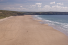
At the northern extremity we found the pattern of a labyrinth marked out in the sand, hoping to be walked before the tide wiped it clean. At the southern end of the beach we crossed the river in Perranporth by stepping stones and paddling: the stones only reached halfway across.
From our B&B window tonight we look straight down the beach back towards Newquay. It's a stunning view, a fitting end to the day.