Sunday, 25 March 2012
Coastwalk , South West Coast Path
Portwrinkle → Plymouth
 Distance: 13.8 miles
Ascent: 628 metres
Duration: 5 hours 1 minute
Sport Relief
« East Looe | Wembury »
Before we get to the walk, we must mention the pub. The Finnygook Inn offers excellent local food and ales, a friendly welcome and a very comfy bed. We needed to let ourselves out early this morning, before the breakfast service started, but the staff very kindly left us some croissants and cereal in a fridge by the stairs so we wouldn't go hungry.
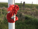 The MOD occupy a large tract of land at Tregantle Fort, and although we knew the range would see live firing later in the day, the warning flags had not been raised when we reached the permissive path across the estate - clearly the notion of an early start doesn't apply to everyone!
The range walk has steadily been extended here in recent years (our guide book made no mention of it , once again recommending road walking instead), so by the time we left the range we were already at the National Trust land at Tregantle Cliff, staying off the road one more.
With Rame Head drawing us forwards we passed through the higgledy-piggledy chalets at Freathy. Only looking back on this section from the path above Penhowan Fort did we see just how these huts encroach on the otherwise beautiful gorse and bramble covered hillside.
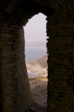 The chapel on top of Rame Head was a disappointment. Open to the elements, there are no visible signs of sanctity here, but it was worth the climb for the hazy views and offered a sense of peace despite being open to the elements and howling wind. Below a small herd of deer lay contentedly on the hillside.
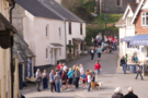
The walking got easier at this point, and before long we found ourselves amidst dozens of others heading along the coast path to complete their Sport Relief Mile. We were consequently part recipients of a misdirected round of applause as we entered Cawsand Square, so marched on to avoid embarrassment all round.
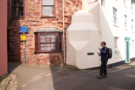
 The division between Cawsand and Kingsand isn't clear, but the old county boundary between Devon and Cornwall is definitively marked in wrought iron on the wall of a house here.
 The route out of Kingsand is another poorly marked point, but if you look for the narrowest, most winding, improbable lane you'll likely find Heavitree Road. These narrow lanes reminded us of Angel Lane in Woodbridge. It's safe to assume we'll return.
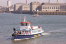 Mount Edgcombe Country Park was the backdrop for the final three miles, a beautiful extensive public park just across the water from Plymouth. So at its eastern end we queued for the Cremyll Ferry, paid our £1.20 fares and joined families enjoying a day out as we crossed the Tamar to Admiral's Hard in Stonehouse, from where we had walked to the east three years ago.