Friday, 11 November 2011
Coastwalk
Barrow-in-Furness → Ulverston
 Distance: 14.3 miles
Ascent: 492 metres
Duration: 4 hours 43 minutes
Endless tarmac
« Askam in Furness | Cark »
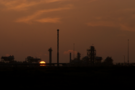
An early start cast Barrow in a new light. The streets were quiet as we tip-toed through the terraces of Salthouse before reaching the coast again on the fringes of Rooscote sands. Ahead the flares of an oil terminal beckoned the rising sun.
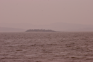
At the village of Rampside we declined the option to cross the causeway to Roa Island, saving a two mile there-and-back walk with the risk of being cut off by the rising tide. (We don't actually know whether or not floodwater ever rises above the road, but today wasn't the time to check. We'll visit the island another time.)
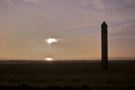
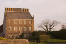
Rampside has two other places of note: the chimney-rich Rampside Hall and a curiously obilisk-like lighthouse. Both worthy of a quick snap, but little more.
Between Rampside and Bardsea the A5087 coastal road follows close to the shore. We dropped down onto the beach between Newbiggin and Aldingham, but otherwise walked in the gutter. Thankfully a true coast path picks up south of Conishead Priory, although it was narrow near the start, and passed through a waterlogged field near the end.
Finally, after skirting the edge of the Cephalosporin plant we reached the pub at Canal Foot.
Threatening, choppy high water made contrasted with the calm we'd seen earlier in the week. It was easy to see how treacherous and deceiving Morecambe Bay can be.
We'd expected to walk back to Ulverston from here, but were delighted to find the friendliest bus I've ever been on. As we walked to our seats, everyone on board greeted us, likewise wishing us a cheery goodbye as we left. This route is threatened with closure under council spending review. For the sake of tired walkers and cheery shoppers, I sincerely hope it is spared.